Home
Browse
Ask Us
Chat
Harmful Language Statement
Log in
Photo Archives
Advanced Search
About
Over 70,000 photos covering a variety of topics from Marriott Library Special Collections
Year
1845
1846
1847
1848
1849
1850
1851
1852
1853
1854
1855
1856
1857
1858
1859
1860
1861
1862
1863
1864
1865
1866
1867
1868
1869
1870
1871
1872
1873
1874
1875
1876
1877
1878
1879
1880
1881
1882
1883
1884
1885
1886
1887
1888
1889
1890
1891
1892
1893
1894
1895
1896
1897
1898
1899
1900
1901
1902
1903
1904
1905
1906
1907
1908
1909
1910
1911
1912
1913
1914
1915
1916
1917
1918
1919
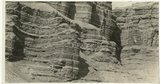
1920
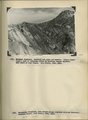
1921
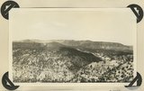
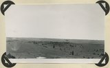
1922
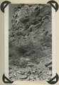
1923
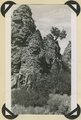
1924
1925
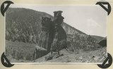
1926
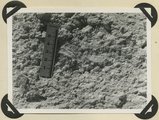
1927
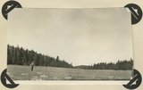
1928
1929
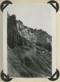
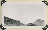
1930
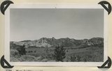
1931
1932
1933
1934
1935
1936
1937
1938
1939
1940
1941
1942
1943
1944
1945
1946
1947
1948
1949
1950
1951
1952
1953
1954
1955
1956
1957
1958
1959
1960
1961
1962
1963
1964
1965
1966
1967
1968
1969
1970
1971
1972
1973
1974
1975
1976
1977
1978
1979
1980
1981
1982
1983
1984
1985
1986
1987
1988
1989
1990
1991
1992
1993
1994
1995
1996
1997
1998
1999
2000
2001
2002
2003
2004
2005
TO
1845
1846
1847
1848
1849
1850
1851
1852
1853
1854
1855
1856
1857
1858
1859
1860
1861
1862
1863
1864
1865
1866
1867
1868
1869
1870
1871
1872
1873
1874
1875
1876
1877
1878
1879
1880
1881
1882
1883
1884
1885
1886
1887
1888
1889
1890
1891
1892
1893
1894
1895
1896
1897
1898
1899
1900
1901
1902
1903
1904
1905
1906
1907
1908
1909
1910
1911
1912
1913
1914
1915
1916
1917
1918
1919
1920
1921
1922
1923
1924
1925
1926
1927
1928
1929
1930
1931
1932
1933
1934
1935
1936
1937
1938
1939
1940
1941
1942
1943
1944
1945
1946
1947
1948
1949
1950
1951
1952
1953
1954
1955
1956
1957
1958
1959
1960
1961
1962
1963
1964
1965
1966
1967
1968
1969
1970
1971
1972
1973
1974
1975
1976
1977
1978
1979
1980
1981
1982
1983
1984
1985
1986
1987
1988
1989
1990
1991
1992
1993
1994
1995
1996
1997
1998
1999
2000
2001
2002
2003
2004
2005
Type
Image
3,622
Image/StillImage
1,837
Format
image/jpeg
5,424
application/pdf
1,139
Collection Name
Olive Woolley Burt
830
Everett Ruess Family
706
Charles Kelly
599
Japanese American relocation photograph collection, 1942-1943
321
EIMCO Photograph Collection
251
The Institute of the American West photograph collection, 1886-1985
213
Shipler Studio
195
Wallace and Mary Doi
173
Reo Robbins
169
Leo Leonard
153
Deseret Livestock Company
147
Ray Yourdon
143
Topaz, Utah and Hispanics in Utah films, 1940-1990
141
Vern Adix
117
Sumi Niiya Takemoto
114
Wallace Stegner
111
Emigration Canyon History
109
J. Willard and Alice Sheets Marriott
107
Albion W. and Agnes Sharp Caine
94
Maud May Babcock
94
Mining Photograph Collection
83
Ruth Harwood
73
C. Lowell Lees
69
Marriner S. Eccles
68
Herbert E. Gregory
65
Ivy Baker Priest
64
Charles Neal
60
Camp Kearns
59
Utah Schools photograph collection
58
Kennecott Copper Corporation
57
G. Bennet Larson
53
Philo T. Farnsworth
45
Salt Lake City, Utah
39
Tooele Army Depot
35
Faith Terasawa
33
Bingham Canyon
29
Greek Archives
29
American Red Cross
27
Noel Okamoto digital photograph collection
27
Joe Hill Conference
26
Fort Douglas
25
Gosiute Indians
24
Utah Railroads
24
E. A. Taylor
23
Alberta Hunt Nicholson photograph collection
22
Arden R. Gaufin
21
George and Jane Beppu Sakashita
21
McIntyre Ranch
21
Waldo Wilcox
18
JoAnne C. Swindle photograph collection
16
LeRoy Robertson photograph collection, 1945-1960
15
United States Fuel Corporation
15
Combined Metals Reduction Company
13
Croydon Utah/Devil's Slide Cement Plant
13
Wasatch Mountain Club
13
Alberta Henry
12
Japanese Oral Histories photograph collection, 1940-1970
12
Vontella Hess Bucholz Kimball
12
George Snell
11
Ivor Sharp
11
Julia Farnsworth Lund Wassmer
11
Jean Westwood
10
Portrait photograph collection
10
John A. Peperakis
9
Salt Lake Oratorio Society photograph collection
9
Seiko and Sumi Oki Arakaki
9
Sigmund and Emma Helwing
9
Alta Club
8
Cotton Mission
8
Geraldine Palmer Jones
8
Jiro (Giro) Mori
8
Ralph Chamberlin
8
Reva Beck Bosone
8
Utah Postcard
8
Byron A. Hunter photograph collection
7
Earl Wells
7
Francis Armstrong
7
Hope A. Hilton
7
John Hamilton Morgan
7
Lucius Marsden Durham
7
Rocky Mountain Power Company
7
Sylvia Eugene Nilsen
7
Uheiji Charles Akita
7
Utah Humanities Research Foundation
7
Wendover Utah Air Base
7
B. Floyd Farr
6
Dave M. Tatsuno
6
Joseph E. Johnson
6
Mike M. Masaoka
6
Utah's Silver Queen: Susanna Egera Bransford Emery Holmes Delitch Engalitcheff photograph collection
6
Charles H. Monson photograph collection
5
Japanese Church of Christ
5
John W. Summerhays
5
Joseph Peck
5
Louis S. Goodman
5
Mack Smith Kesler
5
Masaru Horiuchi
5
Millard F. Malin Photographs
5
Provo, Utah
5
Wanda Clayton Thomas
5
Big Parade War Bond Drive
4
Bill Wolverton
4
Edna Clark Ericksen
4
Francis Urry
4
Henry Y. Kasai
4
Jack Paige
4
Joseph Kingsbury
4
Ray Ogura
4
Rose Thomas Graham
4
Benjamin M. Roe
3
Clarice Short photograph collection
3
Jack Warren Keuffel photograph collection, 1946-1974
3
Japanese American Citizens League Japanese in Utah Exhibit
3
Joy and Lee She Ju digital photograph collection
3
LaVar Webb
3
Louis E. Viko
3
M. Lynn Bennion
3
Park City, Utah
3
Sho and Toshi Yamada Higashi digital photograph collection
3
Sunstone Foundation photograph collection
3
Vyrie Gray
3
Alice Lovina Manning Photographs
2
Arch Leonard Madsen
2
Asael Carlyle
2
Bae B. Gardner
2
Blacks in Utah
2
Burton W. Musser photograph collection, 1900-1966
2
Daniel Hadlond Thomas
2
David Breck Morris
2
David Oman McKay
2
E. Jay Bell
2
George A. Smith
2
Gilsonite Mining
2
Harry L. A. Culmer photograph collection
2
Maurice Abravanel
2
Sara Barnard Johnston photograph collection
2
Stanley Murdock
2
Utah State AFL-CIO
2
A. J. Peters
1
Allen Publishing Company
1
Alvin G. and Lena M. Pack
1
Barbara J. Hamblin
1
Blanche Kendall McKey
1
Carl Weeks Photograph Collection
1
Cheves Walling
1
Colorado
1
Darrell J. Greenwell
1
Dawn Aoki photograph collection
1
Edwin Evans
1
Elma Oman Klitgaard
1
Elmore LeRoy photograph collection
1
Esther Landa photograph collection
1
George Reynolds
1
Helen Bowring Ure photograph collection
1
Italian
1
Janet Pender Healy
1
John Esplin
1
Knight Belnap Kerr photograph collection, 1935-1942
1
Masaji Roy Yoshinaga Photographs
1
Orvil LaVell Sadler
1
Preston Nutter Corporation
1
Topaz Oral Histories photograph collection
1
U of U Fa.
1
U of U Presidents
1
Utah Recreation
1
Vernal, Utah
1
William P. Nisbet photograph collection
1
More
Filters:
Date:
"1943"
Collection:
"uum_map"
76
-
100
of
6,563
<
1
2
3
4
5
6
7
8
9
10
>
Gallery view
Number of results to display per page
10
25
50
100
200
Sort by Relevance
Sort by Title A-Z
Sort by Title Z-A
Sort by Date Ascending
Sort by Date Descending
Sort by Last Modified Ascending
Sort by Last Modified Descending
Sort by Photo Number
Title
Collection Number And Name
Photo Number
76
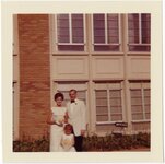
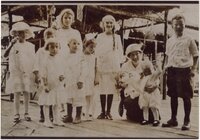
Lees Family [02]
P0005 C. Lowell Lees Photograph Collection
P0005n06_25_002
77
Lees Family [03]
P0005 C. Lowell Lees Photograph Collection
P0005n06_25_003
78
Lees Family [04]
P0005 C. Lowell Lees Photograph Collection
P0005n06_25_004 tif; P0005n06_25_004b.tif
79
Lees Family [05]
P0005 C. Lowell Lees Photograph Collection
P0005n06_25_005
80
Lees Family [06]
P0005 C. Lowell Lees Photograph Collection
P0005n06_25_006
81
Dog [01]
P0005 C. Lowell Lees Photograph Collection
P0005n06_25_009
82
Dog [02]
P0005 C. Lowell Lees Photograph Collection
P0005n06_25_010
83
Lees Family [09]
P0005 C. Lowell Lees Photograph Collection
P0005n06_25_011
84
Lees Family [11]
P0005 C. Lowell Lees Photograph Collection
P0005n06_25_014
85
Herbert E. Gregory Book 12: Colorado Plateau, Province, 1942-1944
P0013 Herbert E. Gregory Photograph Collection
P0013n12
86
Parunuweap formation, Pliocene?, overlying Moenkopi beds (concealed by talus) and capped by basalt. Lower La Verkin Canyon, Washington County, UT, 1943
P0013 Herbert E. Gregory Photograph Collection
P0013n12_007_2854
87
Cretaceous shales (tropic formation). Antimony Canyon, Garfield County, UT. 1943
P0013 Herbert E. Gregory Photograph Collection
P0013n12_010_2854A
88
View looking northeast across Antimony Canyon. Cretaceous strata (foreground and middle distance) below igneous conglomerate and acidic lavas that form the surface of Aquarius Plateau. Garfield County, UT, 1943
P0013 Herbert E. Gregory Photograph Collection
P0013n12_010_2855
89
Entrada sandstone, regular bedded shaly phase overlain by undifferentiated Curtis and Winsor formations. Antimony Canyon, Garfield County, UT, 1943
P0013 Herbert E. Gregory Photograph Collection
P0013n12_011_2856
90
Erosion features in Entrada sandstone. Antimony Canyon, Garfield County, UT, 1943
P0013 Herbert E. Gregory Photograph Collection
P0013n12_011_2857
91
Erosion features in Entrada sandstone. Antimony Canyon, Garfield County, UT, 1943
P0013 Herbert E. Gregory Photograph Collection
P0013n12_012_2858
92
Brian Head formation capped by lava (rhyolite?): Cliff on upthrown side of Paunsaugunt fault. East fork of Sevier River near the mouth of Deer Creek. Garfield County, UT. 1943
P0013 Herbert E. Gregory Photograph Collection
P0013n12_012_2859
93
Detailed view of pumice conglomerate in the Brian Head formation, Casto Bluff, Garfield County, UT, 1943
P0013 Herbert E. Gregory Photograph Collection
P0013n12_013_2860
94
Glaciated surface showing (roche mountain): glade in spruce forest at top of Aquarius Plateau at altitude of 10,800 feet. Near the head of Antimony Creek, Garfield County, UT, 1943
P0013 Herbert E. Gregory Photograph Collection
P0013n12_014_2861_1
95
Glaciated surface showing (roche mountain): glade in spruce forest at top of Aquarius Plateau at altitude of 10,800 feet. Near the head of Antimony Creek, Garfield County, UT, 1943
P0013 Herbert E. Gregory Photograph Collection
P0013n12_014_2861_2
96
Burro Gap on East Fork of Sevier River above mouth of Deer Creek. Locus of Paunsaugunt fault; upthrow on east right. Garfield County, UT. 1943
P0013 Herbert E. Gregory Photograph Collection
P0013n12_015_2862
97
View looking north across Casto Canyon toward the face of the Sevier Plateau. Slope of Brian Head formation beneath gravels (foreground) and in steep white slope ( middle distance) is capped by igneous conglomerates and lavas. Garfield County, UT. 1943
P0013 Herbert E. Gregory Photograph Collection
P0013n12_015_2863
98
Detailed view of pumice conglomerate in the Brian Head formation, Casto Bluff, Garfield County, UT, 1943
P0013 Herbert E. Gregory Photograph Collection
P0013n12_017_2864
99
Surface of Markagunt Plateau looking west from the head of Deedy Hollow. Coated with gravel from decomposed igneous conglomerates and rhyolite. Garfield County, UT. 1943
P0013 Herbert E. Gregory Photograph Collection
P0013n12_017_2865
100
Upper Brian Head formation near the mouth of Deedy Hollow. Garfield County, UT. 1943
P0013 Herbert E. Gregory Photograph Collection
P0013n12_018_2866
76
-
100
of
6,563
<
1
2
3
4
5
6
7
8
9
10
>