|
|
Title | Collection Number And Name | Photo Number |
| 1 |
 |
Herbert E. Gregory Book 12: Colorado Plateau, Province, 1942-1944 | P0013 Herbert E. Gregory Photograph Collection | P0013n12 |
| 2 |
 |
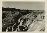
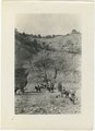
West wall of Seaman Wash | P0013 Herbert E. Gregory Photograph Collection | P0013n12_032_2880 |
| 3 |
 |
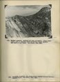
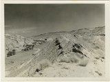
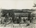
Looking south, up dip, across West Clark Bench, Upper Jurassic and Dakota (butte), to the Paria Terrace, Navajo sandstone. Paria River, which passes through 'The Gap' is joined by Kaibab Creek. Kane County, UT. 1944 | P0013 Herbert E. Gregory Photograph Collection | P0013n12_036_2883 |
| 4 |
 |
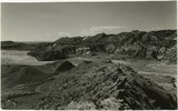
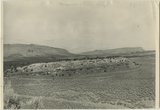
Looking south (up dip) down the Paria River, which has widened its floor and dissected its borders in Upper Jurassic rocks (foreground) and cut a deep narrow canyon in the Navajo sandstone (background). Site of the abandoned Adairville. Kane County UT, 1944 | P0013 Herbert E. Gregory Photograph Collection | P0013n12_038_2885 |
| 5 |
 |
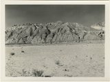
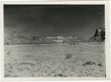
Flat lying Upper Jurassic (foreground) and Cretaceous strata bed abruptly upward against the Navajo on the flank of the East Kaibab monocline (left sky line). Table Cliffs (right sky line) is about 50 miles north. Paria Valley near Adairville. Kane County, UT. 1944 | P0013 Herbert E. Gregory Photograph Collection | P0013n12_039_2886 |
| 6 |
 |
Eroded flank of the East Kaibab monocline at the junction of Paria River and Cottonwood Creek (left center). The sequence is Navajo (left), upper Jurassic (largely eroded), Dakota, Tropic, and Straight Cliffs. Kane County, UT, 1944 | P0013 Herbert E. Gregory Photograph Collection | P0013n12_040_2887 |
| 7 |
 |
Looking south along Paria River from the mouth of Shurtz Gorge. Navajo sandstone in East Kaibab monocline is overlaid with decreasing dips by Upper Jurassic (banked against the Navajo), Dakota, and Tropic (foreground and left sky line). Erosion surface (middle distance) bevels upturned rocks. Kane County, UT, 1944 | P0013 Herbert E. Gregory Photograph Collection | P0013n12_041_2888 |
| 8 |
 |
Panorama {c}. Flank of East Kaibab monocline, bordering alluvial floor of Paria Valley. Navajo sandstone (middle sky line), Upper Jurassic strata, and basal Cretaceous (left). Dips of 40 degrees decrease to 3 degrees within 1,000 feet. Kane County, UT, 1944 | P0013 Herbert E. Gregory Photograph Collection | P0013n12_042_2891 |
| 9 |
 |
Kaibab limestone (lower wall,left, breccia (marks unconformable contact), and basal Moenkopi limestone and shales. Mouth of Kaibab Gulch. Kane County, UT, 1944 | P0013 Herbert E. Gregory Photograph Collection | P0013n12_047-048_2899 |
| 10 |
 |
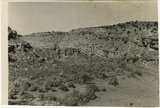
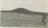
Mesa capped by Dakota sandstone eroded from upper Jurassic Winsor (?) formation. Head of Ash Creek. Kane County, UT | P0013 Herbert E. Gregory Photograph Collection | P0013n12_051_2903A |
| 11 |
 |
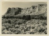
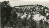
Section of the Shinarump Cliffs (middle distance), east of Pioneer Gap. Shinarump conglomerate exposed by erosion of Moenkopi formation below and the basal strata of the Chinle formation above. Upper Chinle sandstones form Vermilion Cliffs (background). | P0013 Herbert E. Gregory Photograph Collection | P0013n12_052B |
| 12 |
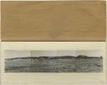 |
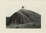
Panorama--4 photographs. Blue Springs meadows. A former valley leading to Mammoth Creek blocked by basalts from Miller Knoll (right skyline) became a lake that eventually cut an outlet northward through the Brian Head formation (upper left). Garfield County, UT, 1944 | P0013 Herbert E. Gregory Photograph Collection | P0013n12_068-069_pan |
| 13 |
 |
Brian Head formation, branch of Asay Creek; lies beneath basalt flows. Garfield County, UT, 1944 | P0013 Herbert E. Gregory Photograph Collection | P0013n12_072_2935 |
| 14 |
 |
Sevier River formation overlaid by basalt near mouth of Corral Creek on Highway 89, 2 miles east of Panguitch. Garfield County, UT. 1944 | P0013 Herbert E. Gregory Photograph Collection | P0013n12_075_2940A |
| 15 |
 |
Bowers Knoll; Volcano viewed from northwest. Garfield County, UT. 1944 | P0013 Herbert E. Gregory Photograph Collection | P0013n12_076_2940B |
| 16 |
 |
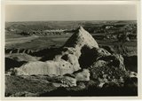
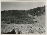
Hillside of eroded rock, Paria Valley, Utah | P0013 Herbert E. Gregory Photograph Collection | P0013n16_12_01 |
| 17 |
 |
Road and lava field, Rock Creek Valley, Utah | P0013 Herbert E. Gregory Photograph Collection | P0013n16_12_02 |
| 18 |
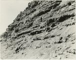 |
Rocky cliff near Hillsdale | P0013 Herbert E. Gregory Photograph Collection | P0013n16_12_03 |
| 19 |
 |
Lava, Black Rock Valley | P0013 Herbert E. Gregory Photograph Collection | P0013n16_12_04 |
| 20 |
 |
Paria Valley and east flank of East Kaibab monocline | P0013 Herbert E. Gregory Photograph Collection | P0013n16_12_05 |
| 21 |
 |
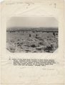
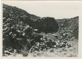
Mound of sedimentary material, vicinity of Paria River, Utah | P0013 Herbert E. Gregory Photograph Collection | P0013n16_12_06 |
| 22 |
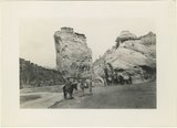 |
Sandstone outcrops, Paria Canyon, Utah | P0013 Herbert E. Gregory Photograph Collection | P0013n16_12_07 |
| 23 |
 |
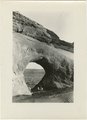
Paria Canyon, Utah | P0013 Herbert E. Gregory Photograph Collection | P0013n16_12_08 |
| 24 |
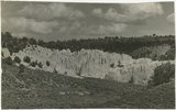 |
White rocks on road to Panquitch, Utah | P0013 Herbert E. Gregory Photograph Collection | P0013n16_12_09 |
| 25 |
 |
East side of Lone Rock on Wah Weap Creek | P0013 Herbert E. Gregory Photograph Collection | P0013n16_12_10 |