|
|
Title | Collection Number And Name | Photo Number |
| 26 |
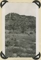 |
Chinle formation, upper red beds near mouth of Box Elder Canyon. Kane County, UT. 1943 | P0013 Herbert E. Gregory Photograph Collection | P0013n12_024_2875 |
| 27 |
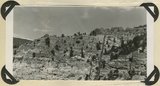 |
Chinle formation, upper red beds capped by remnants of Wingate sandstone. Five Pines Wash. Kane County, UT. 1943 | P0013 Herbert E. Gregory Photograph Collection | P0013n12_024_2876 |
| 28 |
 |
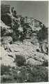
Wingate sandstone, includes bed of limestone. Wall of Flood Canyon. Kane County, UT. 1943 | P0013 Herbert E. Gregory Photograph Collection | P0013n12_025_2877 |
| 29 |
 |
Wingate sandstone, includes bed of limestone. Wall of Flood Canyon. Johnson Lakes. Kane County, UT. 1943 | P0013 Herbert E. Gregory Photograph Collection | P0013n12_025_2877A |
| 30 |
 |
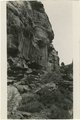
Contact of Kayenta formation (foreground) and Navajo sandstone Park Wash above the mouth of Five Pines Wash. Kane County, UT. 1943 | P0013 Herbert E. Gregory Photograph Collection | P0013n12_026_2877B |
| 31 |
 |
Navajo sandstone north end of No Man's Mesa. Kane County, UT. 1943 | P0013 Herbert E. Gregory Photograph Collection | P0013n12_027_2877C |
| 32 |
 |
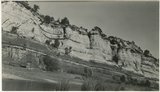
Moenkopi formation: Shnabkaib member (lower part), upper red sandstone (upper middle), Shinarump conglomerate (top). East side of Seamans Wash, Kane County, UT. 1943 | P0013 Herbert E. Gregory Photograph Collection | P0013n12_027_2877D |
| 33 |
 |
Unconformity between Moenkopi formation (lower part) and Shinarump conglomerate. Upper Chinle beds, middle top. Near mouth of Road Canyon. Kane County, UT. 1943 | P0013 Herbert E. Gregory Photograph Collection | P0013n12_028_2877E |
| 34 |
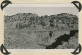 |
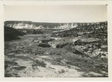
Alluvium valley fill trenched by stream since 1900. Lower Flood Canyon. Kane County, UT. 1943 | P0013 Herbert E. Gregory Photograph Collection | P0013n12_028_2878 |
| 35 |
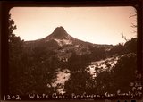 |
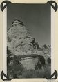
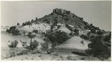
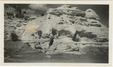
White Cone ("Tabbtimp"), outlier of Navajo sandstone at head of Starlight Canyon. Wall of Paria Canyon (lower right). Kane County, Utah, 1943. | P0013 Herbert E. Gregory Photograph Collection | P0013n12_029_illus1203_neg |
| 36 |
 |
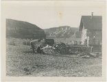
Paria Valley camp, 1943 | P0013 Herbert E. Gregory Photograph Collection | P0013n15_11_04_neg |
| 37 |
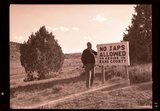 |
"No Japs allowed" sign, 1943 | P0013 Herbert E. Gregory Photograph Collection | P0013n15_11_11_neg |
| 38 |
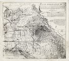 |
Plano geografico de la tierra descubierta y demarcada por Dn. Bernardo de Miera y Paceco al Yumbo del noroeste y oest del Nuevo Mexico, quien fue en compania de los R.R.s P.Ps. Fs. Fran.co Atanacio Dominguez... y Fr. Silvestre Velez de Escalante | P0013 Herbert E. Gregory Photograph Collection | P0013n16_09_04 |
| 39 |
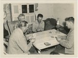 |
Card players, Paria Valley camp, 1943 | P0013 Herbert E. Gregory Photograph Collection | P0013n16_11_01 |
| 40 |
 |
Starlight Canyon 1943 | P0013 Herbert E. Gregory Photograph Collection | P0013n16_11_03 |
| 41 |
 |
Bark Wash, Utah 1943 | P0013 Herbert E. Gregory Photograph Collection | P0013n16_11_04 |
| 42 |
 |
Kitchen Canyon, Utah 1943 | P0013 Herbert E. Gregory Photograph Collection | P0013n16_11_05 |
| 43 |
 |
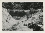
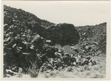
Shinarump outcrop near Paria, 1943 | P0013 Herbert E. Gregory Photograph Collection | P0013n16_11_07 |
| 44 |
 |
Paria Valley camp, 1943 | P0013 Herbert E. Gregory Photograph Collection | P0013n16_11_09 |
| 45 |
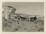 |
Herbert Gregory party at watering station in Paria Valley, Utah | P0013 Herbert E. Gregory Photograph Collection | P0013n16_11_10 |
| 46 |
 |
Paria Valley camp, 1943 | P0013 Herbert E. Gregory Photograph Collection | P0013n16_11_11 |
| 47 |
 |
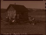
Paria Valley camp, 1943 | P0013 Herbert E. Gregory Photograph Collection | P0013n16_11_13 |
| 48 |
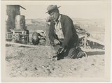 |
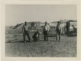
Man and cat, Paria Valley camp, 1943 | P0013 Herbert E. Gregory Photograph Collection | P0013n16_11_14 |
| 49 |
 |
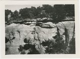
Hillside of eroded rock, Paria Valley, Utah | P0013 Herbert E. Gregory Photograph Collection | P0013n16_12_01 |
| 50 |
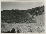 |
Road and lava field, Rock Creek Valley, Utah | P0013 Herbert E. Gregory Photograph Collection | P0013n16_12_02 |