Home
Browse
Ask Us
Chat
Harmful Language Statement
Log in
Photo Archives
Advanced Search
About
Over 70,000 photos covering a variety of topics from Marriott Library Special Collections
Year
1845
1846
1847
1848
1849
1850
1851
1852
1853
1854
1855
1856
1857
1858
1859
1860
1861
1862
1863
1864
1865
1866
1867
1868
1869
1870
1871
1872
1873
1874
1875
1876
1877
1878
1879
1880
1881
1882
1883
1884
1885
1886
1887
1888
1889
1890
1891
1892
1893
1894
1895
1896
1897
1898
1899
1900
1901
1902
1903
1904
1905
1906
1907
1908
1909
1910
1911
1912
1913
1914
1915
1916
1917
1918
1919
1920
1921
1922
1923
1924
1925
1926
1927
1928
1929
1930
1931
1932
1933
1934
1935
1936
1937
1938
1939
1940
1941
1942
1943
1944
1945
1946
1947
1948
1949
1950
1951
1952
1953
1954
1955
1956
1957
1958
1959
1960
1961
1962
1963
1964
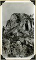
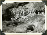
1965
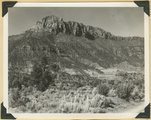
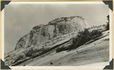
1966
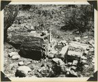
1967
1968
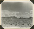
1969
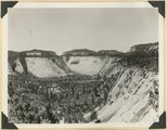
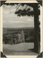
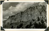
1970
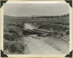
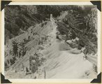
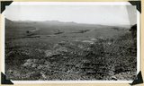
1971
1972
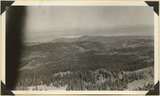
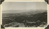
1973
1974
1975
1976
1977
1978
1979
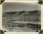
1980
1981
1982
1983
1984
1985
1986
1987
1988
1989
1990
TO
1845
1846
1847
1848
1849
1850
1851
1852
1853
1854
1855
1856
1857
1858
1859
1860
1861
1862
1863
1864
1865
1866
1867
1868
1869
1870
1871
1872
1873
1874
1875
1876
1877
1878
1879
1880
1881
1882
1883
1884
1885
1886
1887
1888
1889
1890
1891
1892
1893
1894
1895
1896
1897
1898
1899
1900
1901
1902
1903
1904
1905
1906
1907
1908
1909
1910
1911
1912
1913
1914
1915
1916
1917
1918
1919
1920
1921
1922
1923
1924
1925
1926
1927
1928
1929
1930
1931
1932
1933
1934
1935
1936
1937
1938
1939
1940
1941
1942
1943
1944
1945
1946
1947
1948
1949
1950
1951
1952
1953
1954
1955
1956
1957
1958
1959
1960
1961
1962
1963
1964
1965
1966
1967
1968
1969
1970
1971
1972
1973
1974
1975
1976
1977
1978
1979
1980
1981
1982
1983
1984
1985
1986
1987
1988
1989
1990
Type
Image
2,680
Format
image/jpeg
2,457
application/pdf
223
Collection Name
Shipler Studio
993
Emigration Canyon History
275
Olive Woolley Burt
162
Deseret Livestock Company
147
Charles Neal
118
Everett Ruess Family
103
G. Ernst Untermann
90
George D. Pyper
85
Mining Photograph Collection
83
Albion W. and Agnes Sharp Caine
69
Herbert E. Gregory
58
G. Bennet Larson
51
Leo Leonard
47
Reo Robbins
44
Greek Archives
43
Wallace Stegner
42
Alta Club
33
Charles Kelly
32
Fort Douglas
28
Rocky Mountain Power Company
18
Waldo Wilcox
18
Melba Goff Matthews
14
Combined Metals Reduction Company
13
Joe Hill Conference
13
Henry Y. Kasai
9
Vyrie Gray
9
Utah Postcard
8
Geraldine Palmer Jones
7
Reva Beck Bosone
7
Hope A. Hilton
6
Preston Nutter Corporation
6
Japanese Church of Christ
5
Millard F. Malin Photographs
5
Provo, Utah
5
Wasatch Mountain Club
5
Seamount Family
4
Vern Adix
4
William Caine Patrick
3
Bingham Stage Lines
2
Southern Slavic
2
Agnes Just Reid
1
Allen Publishing Company
1
Colorado
1
Howard D. Johnson
1
Kunio Yamada digital photograph collection
1
Lyman P. Hunter
1
Madeline R. McQuown
1
Mike M. Masaoka
1
Miles Pratt Romney
1
Philip T. Blair
1
Stephanie Young Merzel
1
U of U Fa.
1
U of U Presidents
1
Works Progress Administration
1
More
Filters:
Date:
"1938"
Collection:
"uum_map"
Type:
"Image"
126
-
150
of
2,680
<
1
2
3
4
5
6
7
8
9
10
>
Gallery view
Number of results to display per page
10
25
50
100
200
Sort by Relevance
Sort by Title A-Z
Sort by Title Z-A
Sort by Date Ascending
Sort by Date Descending
Sort by Last Modified Ascending
Sort by Last Modified Descending
Sort by Photo Number
Title
Collection Number And Name
Photo Number
126
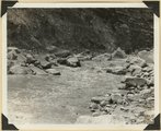
Virgin River in Zion National Park: rising flood from shower on Kolob Terrace
P0013 Herbert E. Gregory Photograph Collection
P0013n11_012_2545
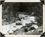
127
Virgin River in Zion National Park: rising flood from shower on Kolob Terrace
P0013 Herbert E. Gregory Photograph Collection
P0013n11_013_2546
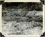
128
Virgin River in Zion National Park: flood stage
P0013 Herbert E. Gregory Photograph Collection
P0013n11_013_2547
129
Virgin River in Zion National Park: flood stage
P0013 Herbert E. Gregory Photograph Collection
P0013n11_014_2548
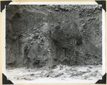
130
Virgin River in Zion National Park: erosion of land slide at flood stage
P0013 Herbert E. Gregory Photograph Collection
P0013n11_015_2549
131
Cave Canyon walls of Navajo sandstone, above them shale and Temple Cap member forms second cliff, capped in turn with Carmel limestone. Zion National Park
P0013 Herbert E. Gregory Photograph Collection
P0013n11_027_2567
132
Smithsonian Butte from north base. Chinle, including Springdale member (middle ledge), Wingate? and Kayenta?, Navajo top. Washington County, UT
P0013 Herbert E. Gregory Photograph Collection
P0013n11_028_2568
133
Petrified log near base of Chinle, north of Rockville. Zion National Park
P0013 Herbert E. Gregory Photograph Collection
P0013n11_028_2569
134
Sevier fault in gully east of Mt. Carmel Junction. Tropic shale, rounded hills (left); Navajo sandstone in fracture zone (right). Kane County, UT
P0013 Herbert E. Gregory Photograph Collection
P0013n11_029_2570
135
Harrisburg Dome near Leeds. Moenkopi and Shinarump strata. Washington County, UT
P0013 Herbert E. Gregory Photograph Collection
P0013n11_029_2571
136
View southeast from Little Bryce Point across Paria amphitheater, pinnacles of Wasatch limestone; upturned edges Navajo sandstone (in distance). Bryce Canyon National Park
P0013 Herbert E. Gregory Photograph Collection
P0013n11_030_2572
137
Valley on Paunsaugunt Plateau. Erosion control dam destroyed by torrential shower, 2.30 inches in 20 minutes. Bryce Canyon National Park
P0013 Herbert E. Gregory Photograph Collection
P0013n11_030_2573
138
North Rim of canyon, Wasatch limestone. Iron Mountain in distance west. Cedar Breaks National Monument
P0013 Herbert E. Gregory Photograph Collection
P0013n11_031_2574
139
Panorama northwest of Brian Head, Markagunt Plateau. Glacial topography foreground; Wasatch formation (middle distance); Little Salt Lake in valley beyond Hurricane Cliffs. Iron County, UT
P0013 Herbert E. Gregory Photograph Collection
P0013n11_031_2575
140
Panorama northwest of Brian Head, Markagunt Plateau. Glacial topography foreground; Wasatch formation (middle distance); Little Salt Lake in valley beyond Hurricane Cliffs. Iron County, UT
P0013 Herbert E. Gregory Photograph Collection
P0013n11_032_2576
141
Lava cap on Straight Cliffs formation foot of dugway in Cedar Canyon. Iron County, UT
P0013 Herbert E. Gregory Photograph Collection
P0013n11_033_2577
142
Fault on Rim Point Wasatch formation. Cedar Break National Monument
P0013 Herbert E. Gregory Photograph Collection
P0013n11_033_2578
143
Spur on wall of canyon. Wasatch limestone. Cedar Breaks National Monument
P0013 Herbert E. Gregory Photograph Collection
P0013n11_034_2579
144
Solution channels in Wingate sandstone, Capitol Gorge. Wayne County, UT
P0013 Herbert E. Gregory Photograph Collection
P0013n11_035_2582
145
View along Notom-Cainesville road. Jurassic and Cretaceous formations. Fremont River in middle distance. Wayne County, UT
P0013 Herbert E. Gregory Photograph Collection
P0013n11_036_2583
146
Erosion on Mancos shales, branch of Fremont River above Cainesville. Wayne County, UT
P0013 Herbert E. Gregory Photograph Collection
P0013n11_036_2584
147
Straight Cliffs sandstone overlying Tropic shale. Back of School House, Orderville, Kane County, UT, 1938
P0013 Herbert E. Gregory Photograph Collection
P0013n11_047_2602
148
Floor of "sink" in Carmel limestone showing solution channels in bedded rock and opening of underground drainage 3 channel. Near Blue Springs, Kolob Terrace, Washington County, UT, 1938
P0013 Herbert E. Gregory Photograph Collection
P0013n11_059_2623
149
Top of East Temple. Carmel limestone (top layers). Temple Cap member of Navajo (cliff), core rock of Navajo (foreground), Washington County, UT, 1938
P0013 Herbert E. Gregory Photograph Collection
P0013n11_060_2626
150
View looking S-SW from foothills 2 miles west of Virgin City. Shnabkaib member of Moenkopi (foreground). Timpoweap member of Moenkopi into which Timpoweap Canyon of the Virgin River is cut (middle distance). Sugar Loaf and other lava capped mesas (left distance)' crest of Hurricane Cliffs (right distance), Washington County, UT, 1938
P0013 Herbert E. Gregory Photograph Collection
P0013n11_061_2627
126
-
150
of
2,680
<
1
2
3
4
5
6
7
8
9
10
>