|
|
Title | Collection Number And Name | Photo Number |
| 26 |
 |
South end of Silurian Mountains from a point about a mile east of Riggs | P0013 Herbert E. Gregory Photograph Collection | P0013n08_181_1696 |
| 27 |
 |
Silurian Dry Lake and north face of the Avanatz Mountains from mine in Silurian Mountains east of Riggs | P0013 Herbert E. Gregory Photograph Collection | P0013n08_181_1697 |
| 28 |
 |
View across old outflow channel of Silver Lake | P0013 Herbert E. Gregory Photograph Collection | P0013n08_182_1698 |
| 29 |
 |
Old outflow channel of Silver Lake looking south from a point 100 yards north of the divide, showing bedrock (granite) at the left in the bed of the channel. Cut where Gregory is standing is an artificial cut | P0013 Herbert E. Gregory Photograph Collection | P0013n08_182_1699 |
| 30 |
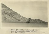 |
Outcrop of Paleozoic limestone (fossils) 1/4 mile SW of Baker | P0013 Herbert E. Gregory Photograph Collection | P0013n08_183_1700 |
| 31 |
 |
Folded gypsum-bearing beds in east bank of Little Rock Creek near San Andreas Rift, Elizabeth Lake Quadrangle | P0013 Herbert E. Gregory Photograph Collection | P0013n08_183_1701 |
| 32 |
 |
Fault between gypsum-bearing beds and granite in San Andreas Rift Zone on east side of Little Rock Creek, Elizabeth Lake Quadrangle. Fault plane nearly vertical | P0013 Herbert E. Gregory Photograph Collection | P0013n08_183_1702 |
| 33 |
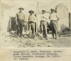 |
Longwell 7, 1924. Shoshone, Amoragosa Valley. Professor Gregory, Rocky Mountain George, Dr. Noble, Dr. Hewett | P0013 Herbert E. Gregory Photograph Collection | P0013n08_187_1709 |
| 34 |
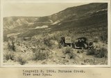 |
Longwell 8, 1924. Furnace Creek. View near Ryan | P0013 Herbert E. Gregory Photograph Collection | P0013n08_187_1710 |
| 35 |
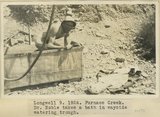 |
Longwell 9, Furnace Creek. Dr. Noble takes a bath in wayside water trough | P0013 Herbert E. Gregory Photograph Collection | P0013n08_188_1711 |
| 36 |
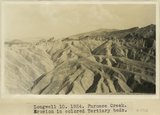 |
Longwell 10, Furnace Creek. Erosion in colored Tertiary beds | P0013 Herbert E. Gregory Photograph Collection | P0013n08_188_1712 |
| 37 |
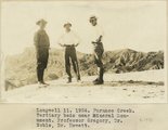 |
Longwell 11, Furnace Creek. Tertiary beds near Mineral Monument. Professor Gregory, Dr. Noble, Dr. Hewett | P0013 Herbert E. Gregory Photograph Collection | P0013n08_189_1713 |
| 38 |
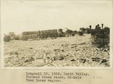 |
Longwell 12, Death Valley. Furnace Creek Ranch. 20-Mule Team Borax wagons | P0013 Herbert E. Gregory Photograph Collection | P0013n08_189_1714 |
| 39 |
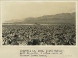 |
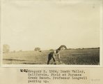
Longwell 13, Death Valley salt deposits, 9 miles south of Furnace Creek Ranch | P0013 Herbert E. Gregory Photograph Collection | P0013n08_190_1715 |
| 40 |
 |
Death Valley, California. Salt floor 9 miles south of Furnace Creek Ranch | P0013 Herbert E. Gregory Photograph Collection | P0013n08_191_1716 |
| 41 |
 |
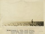
Gregory 2, 1924. Death Valley, California. Field at Furnace Creek Ranch. Professor Longwell packing up | P0013 Herbert E. Gregory Photograph Collection | P0013n08_191_1717 |
| 42 |
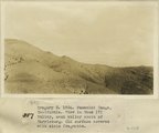 |
Gregory 3, 1924. Panamint Range, California. View in Wood(?) Valley, next valley south of Harrisburg. Old surface covered with slate fragments | P0013 Herbert E. Gregory Photograph Collection | P0013n08_192_1718 |
| 43 |
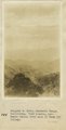 |
Panamint Range, California. View looking into Death Valley from head of Wood(?) Valley | P0013 Herbert E. Gregory Photograph Collection | P0013n08_192_1719 |
| 44 |
 |
Searles Lake, California. Columns of tufa south end of Searles Lake | P0013 Herbert E. Gregory Photograph Collection | P0013n08_193_1720 |
| 45 |
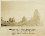 |
Searles Lake, California. Columns of tufa south end of Searles Lake. Marks water level of ancient lake | P0013 Herbert E. Gregory Photograph Collection | P0013n08_193_1721 |
| 46 |
 |
East side Death Valley near Mormon Point | P0013 Herbert E. Gregory Photograph Collection | P0013n09_011_1741 |
| 47 |
 |
East side Death Valley near Mormon Point | P0013 Herbert E. Gregory Photograph Collection | P0013n09_011_1742 |
| 48 |
 |
Consolidated wash materials in canyon east side Death Valley near Mormon Point | P0013 Herbert E. Gregory Photograph Collection | P0013n09_012_1743 |
| 49 |
 |
Death Valley | P0013 Herbert E. Gregory Photograph Collection | P0013n09_012_1744 |
| 50 |
 |
Monorail west end Wingate Pass looking NE | P0013 Herbert E. Gregory Photograph Collection | P0013n09_013_1745 |