|
|
Title | Collection Number And Name | Photo Number |
| 76 |
 |
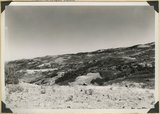
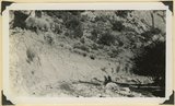
Surface of Kolob Terrace near head of Crystal Creek. Developed on Tropic shale | P0013 Herbert E. Gregory Photograph Collection | P0013n11_172_2798 |
| 77 |
 |
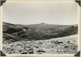
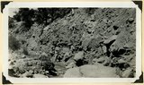
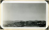
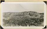
Panorama. Surface of Kolob Terrace near the head of Kolob Creek. Iron County, UT | P0013 Herbert E. Gregory Photograph Collection | P0013n11_172_2799 |
| 78 |
 |
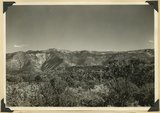
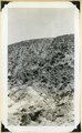
Panorama. Surface of Kolob Terrace near the head of Kolob Creek. Iron County, UT | P0013 Herbert E. Gregory Photograph Collection | P0013n11_173_2800 |
| 79 |
 |
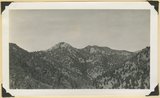
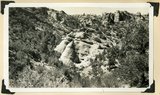
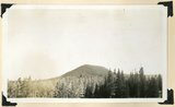
View looking north from near head of South Creek across Coal Canyon, Iron County, UT | P0013 Herbert E. Gregory Photograph Collection | P0013n11_173_2801 |
| 80 |
 |
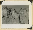
Log Hollow fault (Cretaceous), Kaiparowits formation, on upthrown side (middle and right) in contact with Tertiary (left). Estimated displacement 700 feet. Bowery Canyon, Iron County, UT. 1942 | P0013 Herbert E. Gregory Photograph Collection | P0013n11_174_2802 |
| 81 |
 |
Recent trenching of valley fill of stratified sands and clay, upper part of Spring Creek Canyon, Iron County, UT, 1942 | P0013 Herbert E. Gregory Photograph Collection | P0013n11_174_2803 |
| 82 |
 |
Recent trenching of valley fill of stratified sands and clay, upper part of Spring Creek Canyon, Iron County, UT, 1942 | P0013 Herbert E. Gregory Photograph Collection | P0013n11_175_2804 |
| 83 |
 |
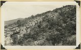
Surface of the Piute Highlands looking north from Mithcell Ridge, Iron County, UT, 1942 | P0013 Herbert E. Gregory Photograph Collection | P0013n11_175_2805 |
| 84 |
 |
Pond confined by a glacial moraine. Dry Lakes road, Iron County, UT, 1942 | P0013 Herbert E. Gregory Photograph Collection | P0013n11_176_2806 |
| 85 |
 |
Kaiparowits formation (Cretaceous) overlain by the Wasatch Tertiary. Bowery Canyon, Iron County, 1942 | P0013 Herbert E. Gregory Photograph Collection | P0013n11_176_2807 |
| 86 |
 |
Kaiparowits formation (Cretaceous) overlain by the Wasatch Tertiary. Bowery Canyon, Iron County, 1942 | P0013 Herbert E. Gregory Photograph Collection | P0013n11_177_2808 |
| 87 |
 |
Kaiparowits formation (Cretaceous) overlain by the Wasatch Tertiary. Bowery Canyon, Iron County, 1942 | P0013 Herbert E. Gregory Photograph Collection | P0013n11_177_2809 |
| 88 |
 |
Conglomerate and underlying arkosic sandstone, Kaiparowits formation, Bowery Canyon, Iron County, UT, 1942 | P0013 Herbert E. Gregory Photograph Collection | P0013n11_178_2810 |
| 89 |
 |
Braffit Point. Mass of conglomerate in the Kaiparowits formation, branch of Parowan Canyon, Iron County, UT, 1942 | P0013 Herbert E. Gregory Photograph Collection | P0013n11_178_2811 |
| 90 |
 |
Carmel formation. Coal Canyon, Iron County, UT. 1942 | P0013 Herbert E. Gregory Photograph Collection | P0013n11_179_2812 |
| 91 |
 |
Carmel formation. Coal Canyon, Iron County, UT. 1942 | P0013 Herbert E. Gregory Photograph Collection | P0013n11_179_2813 |
| 92 |
 |
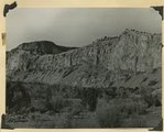
Tilted Cretaceous strata that terminate westward left at the Hurricane fault. Canyon southeast of Summit, Iron County, UT. 1942 | P0013 Herbert E. Gregory Photograph Collection | P0013n11_180_2814 |
| 93 |
 |
Tilted Cretaceous strata that terminate westward left at the Hurricane fault. Canyon southeast of Summit, Iron County, UT. 1942. Wall of Fiddler Canyon | P0013 Herbert E. Gregory Photograph Collection | P0013n11_180_2815 |
| 94 |
 |
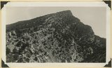
Black Ledge. Cliff of rhyolite that for about 20 miles forms the rim of the Markagunt Plateau. The escarpment is the upthrown side of a fault concealed by the talus. Hoosier Lake, Iron County, UT, 1942 | P0013 Herbert E. Gregory Photograph Collection | P0013n11_181_2816 |
| 95 |
 |
Moenkopi formation (Shnabkaib and upper red members), Shinarump conglomerate, and Chinle formation, all tilted steeply eastward (right). Gulch near the mouth of Coal Canyon, Iron County, UT, 1942 | P0013 Herbert E. Gregory Photograph Collection | P0013n11_182_2817 |
| 96 |
 |
Shnabkaib member of the Moenkopi formation, chiefly gypsiferous beds, tilted in the Kanarra fold. Branch of Shurtz Creek, Iron County, UT. 1942 | P0013 Herbert E. Gregory Photograph Collection | P0013n11_182_2818 |
| 97 |
 |
Virgin limestone (left) and Shnabkaib member of the Moenkopi in vertical position. Kanarra Canyon, Iron County, UT, 1942 | P0013 Herbert E. Gregory Photograph Collection | P0013n11_183_2819 |
| 98 |
 |
Hancock Peak. Volcanic cone, Iron County, UT, 1942 | P0013 Herbert E. Gregory Photograph Collection | P0013n11_183_2820 |
| 99 |
 |
Termination of a basalt flow from Hancock Peak, overriding Wasatch limestone, left. Branch of Mammoth Creek, Iron County, UT, 1942 | P0013 Herbert E. Gregory Photograph Collection | P0013n11_184_2821 |
| 100 |
 |
Basalt flow from Horsetail Mountain near its termination (eastward; right), Iron County, UT, 1942 | P0013 Herbert E. Gregory Photograph Collection | P0013n11_184_2822 |