|
|
Title | Collection Number And Name | Photo Number |
| 226 |
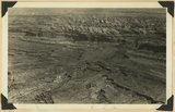 |
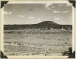
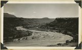
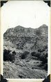
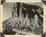
Looking down Fremont Gorge, Capitol Reef from west of Fruita 1936. | P0013 Herbert E. Gregory Photograph Collection | P0013n10_192_2431 |
| 227 |
 |
Rainbow Butte at Paria (Chinle strata). Moenkopi, left foreground, Kane County, Utah, 1937. | P0013 Herbert E. Gregory Photograph Collection | P0013n10_193_2433 |
| 228 |
 |
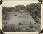
Block Mesas, east of Elephant Gap. Navajo sandstone capped by Carmel. Kane County, Utah, 1936. | P0013 Herbert E. Gregory Photograph Collection | P0013n10_195_2435 |
| 229 |
 |
Fault near Mt. Carmel Junction. Right (up throw side) Carmel limestone; left sands capped by gypsum. Three miles north of Glendale, | P0013 Herbert E. Gregory Photograph Collection | P0013n10_197_2439 |
| 230 |
 |
Straight Cliffs formation (Cretaceous). Orderville, Kane County, Utah. 1936 | P0013 Herbert E. Gregory Photograph Collection | P0013n10_197_2440 |
| 231 |
 |
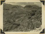
Crater on Kanab Creek, at "the Corrals." Kane County, Utah, 1937. | P0013 Herbert E. Gregory Photograph Collection | P0013n10_198_2443 |
| 232 |
 |
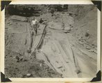
Base of Dakota sandstone resting on white Jurassic. Meadow Brook, Kane County, Utah, 1936. | P0013 Herbert E. Gregory Photograph Collection | P0013n10_198_2445 |
| 233 |
 |
Crossbedded Navajo sandstone along Zion-Mt. Carmel road. Checker Board Mountain on the horizon eastward. Temple Cap member in upper right. Zion National Park, Utah, 1936. | P0013 Herbert E. Gregory Photograph Collection | P0013n10_199_2447 |
| 234 |
 |
Walters Wiggles, in Refrigerator Canyon, on trail to Angels Landing. Navajo strata. Zion National Park, Utah, 1936. | P0013 Herbert E. Gregory Photograph Collection | P0013n10_201_2450 |
| 235 |
 |
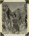
Wingate, Kanab Canyon. | P0013 Herbert E. Gregory Photograph Collection | P0013n10_202_2451 |
| 236 |
 |
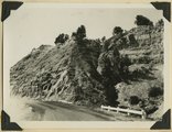
Perched pot holes, Pine Creek, near east end of tunnel, Zion National Park, Utah, 1936. | P0013 Herbert E. Gregory Photograph Collection | P0013n10_202_2453 |
| 237 |
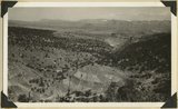 |
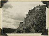
Grafton fault at west end of Smithsonian Butte, looking northward across Virgin River. Coalpits volcano in middle background, edge of Kolob plateau in distance. Washington County, Utah, 1936. | P0013 Herbert E. Gregory Photograph Collection | P0013n10_203_2454 |
| 238 |
 |
Meanders of the Virgin River, near Rockville. Moenkopi capped by Shinarump. Washington County, Utah, 1936. | P0013 Herbert E. Gregory Photograph Collection | P0013n10_203_2455 |
| 239 |
 |
Refrigerator Canyon on the West Rim Trail. Zion National Park, Utah. | P0013 Herbert E. Gregory Photograph Collection | P0013n10_204_2456 |
| 240 |
 |
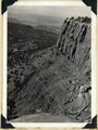
Hurricane Ledge fault zone. View northward from highway, crest of Hurricane Cliffs, west of Virgin City. Kaibab and lowest Moenkopi, right; Moenkopi shale, valley on left; lava capped Toquerville hills beyond it; Kaibab cliffs upper left; Pine Valley mountains left distance. Washington County, Utah, 1936. | P0013 Herbert E. Gregory Photograph Collection | P0013n10_204_2457 |
| 241 |
 |
Zion Park Cliffs, from Shinarump bench, near base of Smithsonian Butte. Virgin River in middle distance; West Temple center distance; at the right Bridge Mountain, East Temple, The Twin Brothers, and Mountain of the Sun. Zion National Park, Utah, 1936. | P0013 Herbert E. Gregory Photograph Collection | P0013n10_205_2458 |
| 242 |
 |
View of the Springdale member of the Chinle, on the west end of Smithsonian Butte. Kane County, Utah, 1936. | P0013 Herbert E. Gregory Photograph Collection | P0013n10_205_2459 |
| 243 |
 |
View of the Springdale member of the Chinle, on the west end of Smithsonian Butte. Kane County, Utah, 1936. | P0013 Herbert E. Gregory Photograph Collection | P0013n10_205_2460 |
| 244 |
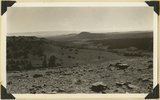 |
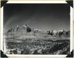
View southeast from top of Brian Head. Hancock Peak in center middle distance; Paunsaugunt Plateau on left horizon. Iron County, Utah, 1936. | P0013 Herbert E. Gregory Photograph Collection | P0013n10_209_2466 |
| 245 |
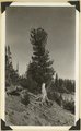 |
Roots of limber pine exposed by erosion, north rim of Cedar Breaks. Iron County, Utah, 1936. | P0013 Herbert E. Gregory Photograph Collection | P0013n10_210_2467 |
| 246 |
 |
Moenkopi capped by Shinarump along road between Fruita and Capitol Wash. Shows pinon trees. Wayne County, Utah, 1936. | P0013 Herbert E. Gregory Photograph Collection | P0013n10_214_2474 |
| 247 |
 |
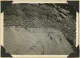
Jointing in Moenkopi sandstone, along road between Fruita on Capitol Wash. Wayne County, Utah, 1936. | P0013 Herbert E. Gregory Photograph Collection | P0013n10_214_2475 |
| 248 |
 |
Basalt in Moenkopi, north wash. | P0013 Herbert E. Gregory Photograph Collection | P0013n10_217_2479 |
| 249 |
 |
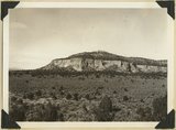
Elkheart Cliffs east of Mt. Carmel. | P0013 Herbert E. Gregory Photograph Collection | P0013n10_218_2480 |
| 250 |
 |
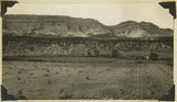
Same as 191 (Looking north across Orderville, Sevier fault), taken nearer Orderville. | P0013 Herbert E. Gregory Photograph Collection | P0013n10_218_2481 |