|
|
Title | Collection Number And Name | Photo Number |
| 126 |
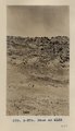 |
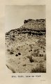
McElmo strata, Holly's ranche, McElmo valley, Colo., 33+ mi. west of Cortez, Colo., 1910 (Photo N-M76) | P0013 Herbert E. Gregory Photograph Collection | P0013n04_04_0517 |
| 127 |
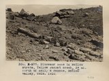 |
Dinosaur bone in McElmo Strata, Yellow Jacket creek, 3+ mi. north of Holly's ranche, McElmo Valley, Colo., 1910 (Photo N-M77) | P0013 Herbert E. Gregory Photograph Collection | P0013n04_04_0518 |
| 128 |
 |
Dinosaur bone in McElmo strata, Yellow Jacket creek, 3± miles north of Holly's ranch, McElmo valley, Colorado. 1910 (Photo N-M77) | P0013 Herbert E. Gregory Photograph Collection | P0013n04_04_0518 |
| 129 |
 |
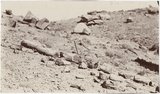
Dinosaur bone in McElmo Strata, Yellow Jacket creek, 3+ mi. north of Holly's ranche, McElmo Valley, Colo., 1910 (Photo N-M77) | P0013 Herbert E. Gregory Photograph Collection | P0013n04_05_0519 |
| 130 |
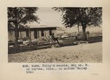 |
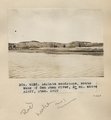
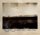
Holly's Ranche. 33+ mi. W. of Cortez, Colo., in McElmo valley, 1910 (Photo G128) | P0013 Herbert E. Gregory Photograph Collection | P0013n04_05_0520 |
| 131 |
 |
McElmo strata, north bank of San Juan River, 10+ mi. below Aneth, Utah, 1910 (Photo G129) | P0013 Herbert E. Gregory Photograph Collection | P0013n04_06_0521 |
| 132 |
 |
McElmo strata, north bank of San Juan River, 10± mi. below Aneth, Utah, 1910 (Photo G129) | P0013 Herbert E. Gregory Photograph Collection | P0013n04_06_0521 |
| 133 |
 |
McElmo strata, north bank of San Juan River, 10+ mi. below Aneth, Utah, 1910 (Photo G130) | P0013 Herbert E. Gregory Photograph Collection | P0013n04_06_0522 |
| 134 |
 |
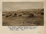
Quartz veins in LaPlata sandstone, north bank of San Juan river, between Aneth and Bluff, U., 1910 (Photo G131) | P0013 Herbert E. Gregory Photograph Collection | P0013n04_07_0523 |
| 135 |
 |
LaPlata sandstone, south bank of San Juan River, 3+ mi. above Bluff, Utah, 1910 (Photo G132) | P0013 Herbert E. Gregory Photograph Collection | P0013n04_07_0524 |
| 136 |
 |
Burros, San Juan Valley, 1910 (Photo N-M78) | P0013 Herbert E. Gregory Photograph Collection | P0013n04_08_0525 |
| 137 |
 |
LaPlata sandstone, south bank of San Juan river, Bluff, Utah, 1910 (Photo G133) | P0013 Herbert E. Gregory Photograph Collection | P0013n04_08_0526 |
| 138 |
 |
"The Twins," LaPlata strata, Bluff, Utah, 1910 (Photo G134) | P0013 Herbert E. Gregory Photograph Collection | P0013n04_09_0527 |
| 139 |
 |
LaPlata sandstone, north bank of San Juan, 3+ mi. west of Bluff, Utah, 1910 (Photo N-M79 | P0013 Herbert E. Gregory Photograph Collection | P0013n04_09_0528 |
| 140 |
 |
View looking west across Comb Wash at Navajo Springs, 12+ mi. west of Bluff, Utah, toward Carboniferous anticline, 1910 (Photo G135) | P0013 Herbert E. Gregory Photograph Collection | P0013n04_10_0529 |
| 141 |
 |
View looking west across Comb Wash at Navajo Springs, 12± miles west of Bluff, UT. 1910 (Photo G135) | P0013 Herbert E. Gregory Photograph Collection | P0013n04_10_0529 |
| 142 |
 |
View looking southwest across Comb Wash at Navajo Springs, 12+ mi. west of Bluff, Utah, toward Carboniferous anticline, 1910 (Photo N-M80) | P0013 Herbert E. Gregory Photograph Collection | P0013n04_10_0530 |
| 143 |
 |
Moencopie strata, north bank of San Juan River (Photo G135A) | P0013 Herbert E. Gregory Photograph Collection | P0013n04_11_0531 |
| 144 |
 |
Mexican Hat, Moencopie strata, San Juan River, 3+ mi. above Goodgridge, Utah (Photo G136) | P0013 Herbert E. Gregory Photograph Collection | P0013n04_11_0532 |
| 145 |
 |
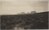
Monument Pass, Utah, from west. 1910 (Photo N-M81) | P0013 Herbert E. Gregory Photograph Collection | P0013n04_11_0533 |
| 146 |
 |
Monument Pass. Utah, from west, 1910 (Photo N-M81) | P0013 Herbert E. Gregory Photograph Collection | P0013n04_11_0533 |
| 147 |
 |
Monument Pass, Utah from west (Moencopie strata), 1910 (Photo G137) | P0013 Herbert E. Gregory Photograph Collection | P0013n04_12_0534 |
| 148 |
 |
Monument Pass, Utah, from west. 1910 (Photo G137) | P0013 Herbert E. Gregory Photograph Collection | P0013n04_12_0534 |
| 149 |
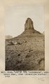 |
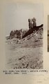
One of the "monuments," Monument Pass, Utah (Moencopie strata), 1910 (Photo G138) | P0013 Herbert E. Gregory Photograph Collection | P0013n04_12_0535 |
| 150 |
 |
One of the monuments, Monument Pass, Utah. Moencopie strata. 1910 (Photo G138) | P0013 Herbert E. Gregory Photograph Collection | P0013n04_12_0535 |