|
|
Title | Collection Number And Name | Photo Number |
| 176 |
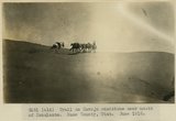 |
Trail on Navajo sandstone near mouth of Escalante. Kane County, UT. June 1918 | P0013 Herbert E. Gregory Photograph Collection | P0013n08_095_1489 |
| 177 |
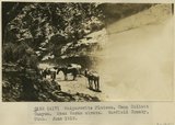 |
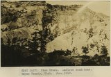
Kaiparowits Plateau, Camp Collett Canyon. Mesa Verde strata. Garfield County, UT. June 1918 | P0013 Herbert E. Gregory Photograph Collection | P0013n08_095_1490 |
| 178 |
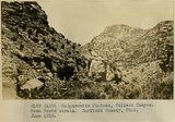 |
Kaiparowits Plateau, Collett Canyon. Mesa Verde strata. Garfield County, UT. June 1918 | P0013 Herbert E. Gregory Photograph Collection | P0013n08_096_1491 |
| 179 |
 |
Escalante. Mormon tithing yard. Garfield County, UT. June 1918 | P0013 Herbert E. Gregory Photograph Collection | P0013n08_096_1492 |
| 180 |
 |
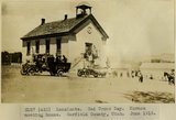
Escalante. Red Cross Day, procession. Garfield County, UT. June 1918 | P0013 Herbert E. Gregory Photograph Collection | P0013n08_097_1493 |
| 181 |
 |
Escalante. Red Cross Day, procession. Garfield County, UT. June 1918 | P0013 Herbert E. Gregory Photograph Collection | P0013n08_097_1494 |
| 182 |
 |
Escalante. Red Cross Day. Mormon meeting house. Garfield County, UT. June 1918 | P0013 Herbert E. Gregory Photograph Collection | P0013n08_098_1495 |
| 183 |
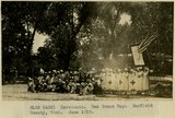 |
Escalante. Red Cross Day. Garfield County, UT. June 1918 | P0013 Herbert E. Gregory Photograph Collection | P0013n08_098_1496 |
| 184 |
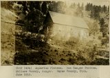 |
Aquarios Plateau. Box Ranger Station. Wallace Roundy, Ranger. Wayne County, UT. June 1918 | P0013 Herbert E. Gregory Photograph Collection | P0013n08_099_1497 |
| 185 |
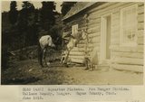 |
Aquarios Plateau. Box Ranger Station. Wallace Roundy, Ranger. Wayne County, UT. June 1918 | P0013 Herbert E. Gregory Photograph Collection | P0013n08_099_1498 |
| 186 |
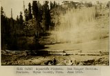 |
Aquarios Plateau. Box Ranger Station. Pasture. Wayne County, UT. June 1918 | P0013 Herbert E. Gregory Photograph Collection | P0013n08_100_1499 |
| 187 |
 |
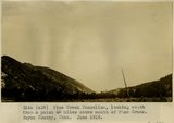
Pine Creek. LaPlata sandstone. Wayne County, UT. June 1918 | P0013 Herbert E. Gregory Photograph Collection | P0013n08_100_1500 |
| 188 |
 |
Escalante Monocline, looking north from a point 4 miles above mouth of Pine Creek. Wayne County, UT. June 1918 | P0013 Herbert E. Gregory Photograph Collection | P0013n08_101_1501 |
| 189 |
 |
Escalante Monocline, looking north from a point 4 miles above mouth of Pine Creek. Wayne County, UT. June 1918 | P0013 Herbert E. Gregory Photograph Collection | P0013n08_101_1502 |
| 190 |
 |
Beaver dam at Boulder. Garfield County, UT. June 1918 | P0013 Herbert E. Gregory Photograph Collection | P0013n08_102_1503 |
| 191 |
 |
Irrigated fields at Boulder surrounded by LaPlata sandstone. Garfield County, UT. June 1918 | P0013 Herbert E. Gregory Photograph Collection | P0013n08_102_1504 |
| 192 |
 |
Escalante Canyon. Escalante Arch, natural bridge in LaPlata Sandstone. Garfield County, UT. June 1918 | P0013 Herbert E. Gregory Photograph Collection | P0013n08_103_1505 |
| 193 |
 |
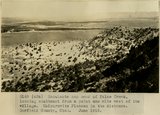
Escalante Valley, looking northwest from a point one mile west of Escalante. Garfield Co, UT. June 1918 | P0013 Herbert E. Gregory Photograph Collection | P0013n08_103_1506 |
| 194 |
 |
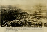
Escalante and head of False Creek, looking southeast from a point one mile west of the village. Kaiparowits Plateau in the distance. Garfield County, UT. June 1918 | P0013 Herbert E. Gregory Photograph Collection | P0013n08_104_1507 |
| 195 |
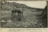 |
Bed of Upper Wahweap. Kane County, UT. June 1918 | P0013 Herbert E. Gregory Photograph Collection | P0013n08_108_1517 |
| 196 |
 |
Along Wahweap Stream. Cross bedding sandstone. Kane County, UT. June 1918 | P0013 Herbert E. Gregory Photograph Collection | P0013n08_108_1518 |
| 197 |
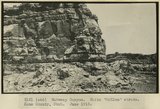 |
Wahweap Canyon. White 'McElmo' strata. Kane County, UT. June 1918 | P0013 Herbert E. Gregory Photograph Collection | P0013n08_109_1519 |
| 198 |
 |
Wahweap Canyon. White 'McElmo' strata. Kane County, UT. June 1918 | P0013 Herbert E. Gregory Photograph Collection | P0013n08_109_1520 |
| 199 |
 |
Wahweap Canyon. White 'McElmo' strata. Kane County, UT. June 1918 | P0013 Herbert E. Gregory Photograph Collection | P0013n08_110_1521 |
| 200 |
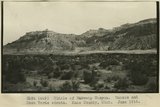 |
Middle of Wahweap Canyon. Mancos and Mesa Verde strata. Kane County, UT. June 1918 | P0013 Herbert E. Gregory Photograph Collection | P0013n08_110_1522 |