|
|
Title | Collection Number And Name | Photo Number |
| 201 |
 |
Same as 809 (Natural Bridge, Bridge Canyon 3 miles northeast of Fruita, Wayne County, Utah), 1937. | P0013 Herbert E. Gregory Photograph Collection | P0013n10_181_2406 |
| 202 |
 |
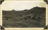
Moenkopi and wash near Fruita, 1937. | P0013 Herbert E. Gregory Photograph Collection | P0013n10_182_2407 |
| 203 |
 |
Near Fruita, Ut. | P0013 Herbert E. Gregory Photograph Collection | P0013n10_182_2407 |
| 204 |
 |
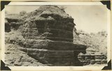
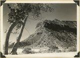
Split Tower, Wingate sandstone underlaid by Chinle beds, 2+ miles northwest of Fruita, Wayne County, Utah, 1937. | P0013 Herbert E. Gregory Photograph Collection | P0013n10_182_2408 |
| 205 |
 |
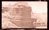
Chinle and Wingate, Fremont River near Fruita, Wayne County, Utah, 1937. | P0013 Herbert E. Gregory Photograph Collection | P0013n10_183_2409 |
| 206 |
 |
Platform top of Navajo sandstone, Capitol Reef. Rim of Fremont River gorge in foreground. Wayne County, Utah, 1937. | P0013 Herbert E. Gregory Photograph Collection | P0013n10_183_2410 |
| 207 |
 |
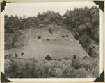
Shinarump sandstone (full thickness) underlaid by Moenkopi along Torrey-Fruita road, Wayne County, Utah, 1937. | P0013 Herbert E. Gregory Photograph Collection | P0013n10_184_2411 |
| 208 |
 |
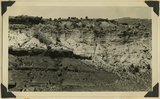
Boulders of lava on eroded surface of Moenkopi along Torrey-Fruita road, Wayne County, Utah, 1937. | P0013 Herbert E. Gregory Photograph Collection | P0013n10_184_2412 |
| 209 |
 |
Pinnacles in Navajo sandstone south side Fremont River below Fruita, 1937. | P0013 Herbert E. Gregory Photograph Collection | P0013n10_185_2413 |
| 210 |
 |
Pinnacles, Freemont River | P0013 Herbert E. Gregory Photograph Collection | P0013n10_185_2413 |
| 211 |
 |
Unconformity west of Paria. Middle white, Shinarump; lower left, dark, Moenkopi; upper beds, Chinle. Kane County, Utah, 1937. | P0013 Herbert E. Gregory Photograph Collection | P0013n10_193_2432 |
| 212 |
 |
Triassic formations at Paria. Foreground, Moenkopi along road (dark) and Shinarump (light). Butte: Chinle (banded) capped with Wingate sandstone, Kane County, Utah, 1937. | P0013 Herbert E. Gregory Photograph Collection | P0013n10_194_2434 |
| 213 |
 |
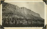
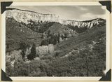
Elkheart Cliffs, blood-red buttes at base, on east side of the Sevier fault near Orderville,Kane County, Utah, 1937. | P0013 Herbert E. Gregory Photograph Collection | P0013n10_196_2436 |
| 214 |
 |
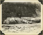
Mud flow, result of sudden shower in branch of Parunuweap River: break in highway. Three miles north of Glendale, Kane County, Utah, 1937. | P0013 Herbert E. Gregory Photograph Collection | P0013n10_196_2437 |
| 215 |
 |
Mud flow, result of sudden shower in branch of Parunuweap River: 1200 feet downstream. Three miles north of Glendale, Kane County, Utah, 1937. | P0013 Herbert E. Gregory Photograph Collection | P0013n10_196_2438 |
| 216 |
 |
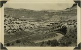
General view of tilted, from Kanab Road. Looking northwest across Sevier fault and Parunuweap River at Mt. Carmel, Kane County, Utah, 1937. | P0013 Herbert E. Gregory Photograph Collection | P0013n10_197_2441 |
| 217 |
 |
Tilted block broken from Sevier fault, Navajo capped by Carmel. Orderville, Kane County, Utah, 1937. | P0013 Herbert E. Gregory Photograph Collection | P0013n10_198_2442 |
| 218 |
 |
Pink Cliffs, Robinson Canyon, north of Alton. Cretaceous (Kaiparowits) contact with Wasatch (Tertiary) at the base of vertical cliffs. Kane County, Utah, 1937. | P0013 Herbert E. Gregory Photograph Collection | P0013n10_198_2444 |
| 219 |
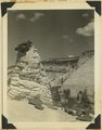 |
Tower of Navajo sandstone capped by iron concretion along highway near east Checking Station, Zion National Park, Utah, 1936. | P0013 Herbert E. Gregory Photograph Collection | P0013n10_199_2446 |
| 220 |
 |
Muhim Cliff Profile Indian Head Chinle strata. Springdale, Utah, 1937. | P0013 Herbert E. Gregory Photograph Collection | P0013n10_201_2449 |
| 221 |
 |
Wingate, Kanab Canyon. | P0013 Herbert E. Gregory Photograph Collection | P0013n10_202_2451 |
| 222 |
 |
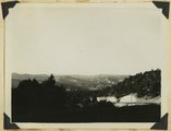
Virgin River at La Verkin Hot Springs. Shacks are shelters over intake pipes leading to the pool quarter of a mile down the river. Washington County, Utah, 1937. | P0013 Herbert E. Gregory Photograph Collection | P0013n10_202_2452 |
| 223 |
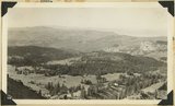 |
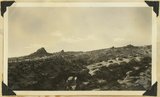
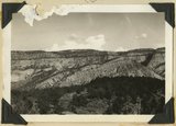
View southwest from Brian Head, showing head of Cedar Canyon, the northern Kolob Plateau, and Pine Valley Mountains (in distance). Iron County, Utah, 1937. | P0013 Herbert E. Gregory Photograph Collection | P0013n10_207_2462 |
| 224 |
 |
View north along the rim of Markagunt Plateau from Brian Head. Iron County, Utah, 1937. | P0013 Herbert E. Gregory Photograph Collection | P0013n10_208_2463 |
| 225 |
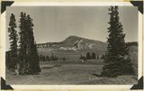 |
Brian Head, volcanic mass from the north rim of Cedar Breaks, Iron County, Utah, 1937. | P0013 Herbert E. Gregory Photograph Collection | P0013n10_208_2464 |