Home
Browse
Ask Us
Chat
Harmful Language Statement
Log in
Photo Archives
Advanced Search
About
Over 70,000 photos covering a variety of topics from Marriott Library Special Collections
Year
1845
1846
1847
1848
1849
1850
1851
1852
1853
1854
1855
1856
1857
1858
1859
1860
1861
1862
1863
1864
1865
1866
1867
1868
1869
1870
1871
1872
1873
1874
1875
1876
1877
1878
1879
1880
1881
1882
1883
1884
1885
1886
1887
1888
1889
1890
1891
1892
1893
1894
1895
1896
1897
1898
1899
1900
1901
1902
1903
1904
1905
1906
1907
1908
1909
1910
1911
1912
1913
1914
1915
1916
1917
1918
1919
1920
1921
1922
1923
1924
1925
1926
1927
1928
1929
1930
1931
1932
1933
1934
1935
1936
1937
1938
1939
1940
1941
1942
1943
1944
1945
1946
1947
1948
1949
1950
1951
1952
1953
1954
1955
1956
1957
1958
1959
1960
1961
1962
1963
1964
1965
1966
1967
1968
1969
1970
1971
1972
1973
1974
1975
1976
1977
1978
1979
1980
1981
1982
1983
1984
1985
1986
1987
1988
1989
1990
1991
1992
1993
1994
1995
1996
1997
1998
1999
2000
TO
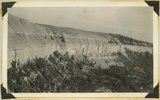
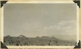
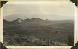
1845
1846
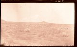
1847
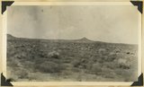
1848
1849
1850
1851
1852
1853
1854
1855
1856
1857
1858
1859
1860
1861
1862
1863
1864
1865
1866
1867
1868
1869
1870
1871
1872
1873
1874
1875
1876
1877
1878
1879
1880
1881
1882
1883
1884
1885
1886
1887
1888
1889
1890
1891
1892
1893
1894
1895
1896
1897
1898
1899
1900
1901
1902
1903
1904
1905
1906
1907
1908
1909
1910
1911
1912
1913
1914
1915
1916
1917
1918
1919
1920
1921
1922
1923
1924
1925
1926
1927
1928
1929
1930
1931
1932
1933
1934
1935
1936
1937
1938
1939
1940
1941
1942
1943
1944
1945
1946
1947
1948
1949
1950
1951
1952
1953
1954
1955
1956
1957
1958
1959
1960
1961
1962
1963
1964
1965
1966
1967
1968
1969
1970
1971
1972
1973
1974
1975
1976
1977
1978
1979
1980
1981
1982
1983
1984
1985
1986
1987
1988
1989
1990
1991
1992
1993
1994
1995
1996
1997
1998
1999
2000
Type
Image
2,436
Image/StillImage
1,156
Format
image/jpeg
4,549
Collection Name
Shipler Studio
893
Everett Ruess Family
359
Emigration Canyon History
275
The Institute of the American West photograph collection, 1886-1985
255
Ruth Harwood
223
Herbert E. Gregory
151
Deseret Livestock Company
147
Maud May Babcock
136
Charles Neal
118
Kennecott Copper Corporation
95
Ray Yourdon
92
William Manning Green
92
G. Ernst Untermann
90
George D. Pyper
85
Mining Photograph Collection
83
Albion W. and Agnes Sharp Caine
69
Reo Robbins
58
J. Willard and Alice Sheets Marriott
54
G. Bennet Larson
52
Greek Archives
47
Carl Weeks Photograph Collection
46
Philo T. Farnsworth
45
Sumi Niiya Takemoto
45
Ivy Baker Priest
42
Leo Leonard
40
Omer Call Stewart photograph collection
38
Charles Kelly
34
Alta Club
33
Sigmund and Emma Helwing
31
Marriner S. Eccles
30
Olive Woolley Burt
30
Fort Douglas
28
Topaz, Utah and Hispanics in Utah films, 1940-1990
28
Wasatch Mountain Club
28
A. J. Peters
25
Gosiute Indians
24
Utah Railroads
24
Wallace Stegner
24
E. A. Taylor
23
Utah's Silver Queen: Susanna Egera Bransford Emery Holmes Delitch Engalitcheff photograph collection
23
Bingham Canyon
20
American Red Cross
19
Waldo Wilcox
18
C. Lowell Lees
17
Clarence Stevenson
16
Clifford Percy Evans
16
JoAnne C. Swindle photograph collection
16
Melba Goff Matthews
14
Combined Metals Reduction Company
13
Croydon Utah/Devil's Slide Cement Plant
13
Joe Hill Conference
13
Julia Farnsworth Lund Wassmer
12
Vern Adix
12
George Snell
11
Elsie Ross Whittaker
10
Francis Armstrong
10
Henry Y. Kasai
9
Jean Westwood
9
Portrait photograph collection
9
Utah Humanities Research Foundation
9
Vyrie Gray
9
John A. Peperakis
8
Reva Beck Bosone
8
Utah Postcard
8
Charles N. Strevell
7
Rocky Mountain Power Company
7
Alberta Henry
6
Geraldine Palmer Jones
6
Hope A. Hilton
6
McLean Watters
6
Preston Nutter Corporation
6
Ralph Chamberlin
6
Salt Lake Oratorio Society photograph collection
6
Sylvia Eugene Nilsen
6
Vontella Hess Bucholz Kimball
6
Clarice Short photograph collection
5
Ivor Sharp
5
Joseph E. Johnson
5
Mark A. Pendleton
5
Millard F. Malin Photographs
5
Provo, Utah
5
Uheiji Charles Akita
5
Wanda Clayton Thomas
5
Faith Terasawa
4
Garfield, Utah
4
History of Bingham Canyon
4
Mack Smith Kesler
4
Rose Thomas Graham
4
Seamount Family
4
B. Floyd Farr
3
David Oman McKay
3
Francis Urry
3
Helen Bowring Ure photograph collection
3
Jack Warren Keuffel photograph collection, 1946-1974
3
Joy and Lee She Ju digital photograph collection
3
Park City, Utah
3
William Caine Patrick
3
Alice Lovina Manning Photographs
2
Arch Leonard Madsen
2
Asael Carlyle
2
Bingham Stage Lines
2
Burton W. Musser photograph collection, 1900-1966
2
Byron A. Hunter photograph collection
2
Daniel Hadlond Thomas
2
E. Jay Bell
2
Earl Wells
2
Edna Clark Ericksen
2
Edna Peterson Price
2
Esther Landa photograph collection
2
Harry L. A. Culmer photograph collection
2
Italian
2
Japanese American Citizens League Japanese in Utah Exhibit
2
Japanese Church of Christ
2
John Hamilton Morgan
2
Kunio Yamada digital photograph collection
2
LeRoy Robertson photograph collection, 1945-1960
2
Mike M. Masaoka
2
Utah Schools photograph collection
2
Wallace and Mary Doi
2
Yosaburo Takehara digital photograph collection
2
Agnes Just Reid
1
Alvin G. and Lena M. Pack
1
Barbara J. Hamblin
1
Benjamin M. Roe
1
Charles H. Monson photograph collection
1
Colorado
1
Darrell J. Greenwell
1
Dawn Aoki photograph collection
1
Edith LeRoy Richardson
1
Elmore LeRoy photograph collection
1
Frederick J. Pack
1
George A. Smith
1
George Reynolds
1
Hiram B. Clawson
1
John W. Summerhays
1
John and Elva Murdock
1
Joseph Kingsbury
1
Knight Belnap Kerr photograph collection, 1935-1942
1
Lyman P. Hunter
1
Madeline R. McQuown
1
Marvin H. Strong photograph collection
1
Maurice Abravanel
1
Miles Pratt Romney
1
Native American
1
Philip T. Blair
1
Sunstone Foundation photograph collection
1
U of U Presidents
1
Utah Scottish Association photograph collection
1
Works Progress Administration
1
More
Filters:
Date:
"1937"
Format:
"image/jpeg"
Collection:
"uum_map"
151
-
175
of
4,549
<
2
3
4
5
6
7
8
9
10
11
>
Gallery view
Number of results to display per page
10
25
50
100
200
Sort by Relevance
Sort by Title A-Z
Sort by Title Z-A
Sort by Date Ascending
Sort by Date Descending
Sort by Last Modified Ascending
Sort by Last Modified Descending
Sort by Photo Number
Title
Collection Number And Name
Photo Number
151
Shale formation where fossils are found. Near the Pine Creek bridge at the base of the switchboard on new Mt. Carmel road, Zion Canyon.
P0013 Herbert E. Gregory Photograph Collection
P0013n10_065_2199
152
The Virgin Mesa from top of Hurricane Hill.
P0013 Herbert E. Gregory Photograph Collection
P0013n10_066_2200
153
Virgin Mesa from highway below Rockville, Utah.
P0013 Herbert E. Gregory Photograph Collection
P0013n10_066_2201
154
Crossbedding of sandstone along Mt. Carmel road. Indicating wind action and sand dune formation prior to the formation of rock.
P0013 Herbert E. Gregory Photograph Collection
P0013n10_067_2202
155
Curvillinear fractures in sandstone, west wall of Temple of Sinawava, Zion Canyon.
P0013 Herbert E. Gregory Photograph Collection
P0013n10_068_2203
156
Wind and water erosion in sandstone. In Zion Canyon on west side of the Virgin River, about one-half mile above checking station.
P0013 Herbert E. Gregory Photograph Collection
P0013n10_069_2204
157
Half Arch. East side of Narrows, Zion Canyon, above Temple of Sinawava.
P0013 Herbert E. Gregory Photograph Collection
P0013n10_070_2205
158
Hidden Canyon from Observation Point. A typical hanging canyon or valley.
P0013 Herbert E. Gregory Photograph Collection
P0013n10_071_2206
159
Volcanic cone, two miles west of Hurricane, Utah.
P0013 Herbert E. Gregory Photograph Collection
P0013n10_071_2207
160
Lava flow over gravel wash. South of Toquerville, Utah, along main road from Zion Canyon to Anderson's Ranch.
P0013 Herbert E. Gregory Photograph Collection
P0013n10_072_2208
161
View southwest toward the rim of Bryce Canyon from the north side of lower canyon near the Fairy Temple trail.
P0013 Herbert E. Gregory Photograph Collection
P0013n10_074_2209
162
View east toward Seal Castle and Fairy Temple. "Lot's wife" in the foreground.
P0013 Herbert E. Gregory Photograph Collection
P0013n10_075_2210
163
View looking west across valley cut in top Jurassic and Tropic shale (Cretaceous) at head of La Verkin Creek. In distance Timber top and other mesas of Navajo sandstone that form Hurrican Cliffs, Washington County, Utah, 1937.
P0013 Herbert E. Gregory Photograph Collection
P0013n10_166_2377
164
Tropic shale, Cretaceous, head of La Verkin Canyon. Washington County, Utah, 1937.
P0013 Herbert E. Gregory Photograph Collection
P0013n10_167_2378
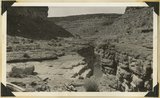
165
Timpoweap Canyon (Virgin River); Kaibab formation in bed of stream; conglomerate on rim, thin Kaibab; Timpoweap member of Moenkopi in cliffs. Washington County, Utah, 1937.
P0013 Herbert E. Gregory Photograph Collection
P0013n10_167_2379
166
Timpoweap Canyon, Virgin River, bedded conglomerate between beds of Kaibab limestone. Washington County, Utah, 1937.
P0013 Herbert E. Gregory Photograph Collection
P0013n10_168_2380
167
Looking north across Timpoweap Canyon: foreground Kaibab; middle flat, base of Moenkopi red shales; distance, Moenkopi capped by Shinarump; platform at upper left, Virgin limestone member. Washington County, Utah, 1937.
P0013 Herbert E. Gregory Photograph Collection
P0013n10_169_2381
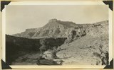
168
Row of basalt capped Moenkopi mesas near the crest of Hurricane Cliffs south of Hurricane; Sugar loaf in lower right; Pine Valley Mountain. Washington County, Utah, 1937.
P0013 Herbert E. Gregory Photograph Collection
P0013n10_169_2382
169
Same as 795 (Row of basalt capped Moenkopi mesas near the crest of Hurricane Cliffs south of Hurricane; Sugar loaf in lower right; Pine Valley Mountain) but showing also in foreground Workman Wash border by low cliffs of Virgin limestone, Moenkopi. Washington County, Utah, 1937.
P0013 Herbert E. Gregory Photograph Collection
P0013n10_170_2383
170
Gray Knoll, Washington County, Ut.
P0013 Herbert E. Gregory Photograph Collection
P0013n10_170_2384
171
Sugar Loaf looking northwest from flat along Workman Wash. Washington County, Utah, 1937.
P0013 Herbert E. Gregory Photograph Collection
P0013n10_170_2384
172
Gray Knoll, volcanic cone on Little Creek Mountain. General surface of Shinarump conglomerate; Moenkopi low cliffs in foreground. Washington County, Utah, 1937.
P0013 Herbert E. Gregory Photograph Collection
P0013n10_171_2385
173
View looking west toward Canaan Gap of Short Creek. Road on Arizona-Utah line; foreground, flat cut in lowest Chinle beds; background, cliffs and ridges of eastward dipping Shinarump overlying Moenkopi. Washington County, Utah, 1937.
P0013 Herbert E. Gregory Photograph Collection
P0013n10_171_2386
174
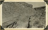
Short Creek near village of Short Creek. Cutting of its channel 20-30 feet done since about 1885. Mohave County, Arizona, 1937.
P0013 Herbert E. Gregory Photograph Collection
P0013n10_172_2387
175
Same as 799 (Short Creek near village of Short Creek. Cutting of its channel 20-30 feet done since about 1885. Mohave County, Arizona, 1937). Point of Vermillion Cliff in upper left.
P0013 Herbert E. Gregory Photograph Collection
P0013n10_172_2388
151
-
175
of
4,549
<
2
3
4
5
6
7
8
9
10
11
>