Home
Browse
Ask Us
Chat
Harmful Language Statement
Log in
Photo Archives
Advanced Search
About
Over 70,000 photos covering a variety of topics from Marriott Library Special Collections
Year
1845
1846
1847
1848
1849
1850
1851
1852
1853
1854
1855
1856
1857
1858
1859
1860
1861
1862
1863
1864
1865
1866
1867
1868
1869
1870
1871
1872
1873
1874
1875
1876
1877
1878
1879
1880
1881
1882
1883
1884
1885
1886
1887
1888
1889
1890
1891
1892
1893
1894
1895
1896
1897
1898
1899
1900
1901
1902
1903
1904
1905
1906
1907
1908
1909
1910
1911
1912
1913
1914
1915
1916
1917
1918
1919
1920
1921
1922
1923
1924
1925
1926
1927
1928
1929
1930
1931
1932
1933
1934
1935
1936
1937
1938
1939
1940
1941
1942
1943
1944
1945
1946
1947
1948
1949
1950
1951
1952
1953
1954
1955
1956
1957
1958
1959
1960
1961
1962
1963
1964
1965
1966
1967
1968
1969
1970
1971
1972
1973
1974
1975
1976
1977
1978
1979
1980
1981
1982
1983
1984
1985
1986
1987
1988
1989
1990
1991
1992
1993
1994
1995
1996
1997
1998
1999
2000
TO
1845
1846
1847
1848
1849
1850
1851
1852
1853
1854
1855
1856
1857
1858
1859
1860
1861
1862
1863
1864
1865
1866
1867
1868
1869
1870
1871
1872
1873
1874
1875
1876
1877
1878
1879
1880
1881
1882
1883
1884
1885
1886
1887
1888
1889
1890
1891
1892
1893
1894
1895
1896
1897
1898
1899
1900
1901
1902
1903
1904
1905
1906
1907
1908
1909
1910
1911
1912
1913
1914
1915
1916
1917
1918
1919
1920
1921
1922
1923
1924
1925
1926
1927
1928
1929
1930
1931
1932
1933
1934
1935
1936
1937
1938
1939
1940
1941
1942
1943
1944
1945
1946
1947
1948
1949
1950
1951
1952
1953
1954
1955
1956
1957
1958
1959
1960
1961
1962
1963
1964
1965
1966
1967
1968
1969
1970
1971
1972
1973
1974
1975
1976
1977
1978
1979
1980
1981
1982
1983
1984
1985
1986
1987
1988
1989
1990
1991
1992
1993
1994
1995
1996
1997
1998
1999
2000
Type
Image
2,436
Image/StillImage
1,156
Format
image/jpeg
4,549
Collection Name
Shipler Studio
893
Everett Ruess Family
359
Emigration Canyon History
275
The Institute of the American West photograph collection, 1886-1985
255
Ruth Harwood
223
Herbert E. Gregory
151
Deseret Livestock Company
147
Maud May Babcock
136
Charles Neal
118
Kennecott Copper Corporation
95
Ray Yourdon
92
William Manning Green
92
G. Ernst Untermann
90
George D. Pyper
85
Mining Photograph Collection
83
Albion W. and Agnes Sharp Caine
69
Reo Robbins
58
J. Willard and Alice Sheets Marriott
54
G. Bennet Larson
52
Greek Archives
47
Carl Weeks Photograph Collection
46
Philo T. Farnsworth
45
Sumi Niiya Takemoto
45
Ivy Baker Priest
42
Leo Leonard
40
Omer Call Stewart photograph collection
38
Charles Kelly
34
Alta Club
33
Sigmund and Emma Helwing
31
Marriner S. Eccles
30
Olive Woolley Burt
30
Fort Douglas
28
Topaz, Utah and Hispanics in Utah films, 1940-1990
28
Wasatch Mountain Club
28
A. J. Peters
25
Gosiute Indians
24
Utah Railroads
24
Wallace Stegner
24
E. A. Taylor
23
Utah's Silver Queen: Susanna Egera Bransford Emery Holmes Delitch Engalitcheff photograph collection
23
Bingham Canyon
20
American Red Cross
19
Waldo Wilcox
18
C. Lowell Lees
17
Clarence Stevenson
16
Clifford Percy Evans
16
JoAnne C. Swindle photograph collection
16
Melba Goff Matthews
14
Combined Metals Reduction Company
13
Croydon Utah/Devil's Slide Cement Plant
13
Joe Hill Conference
13
Julia Farnsworth Lund Wassmer
12
Vern Adix
12
George Snell
11
Elsie Ross Whittaker
10
Francis Armstrong
10
Henry Y. Kasai
9
Jean Westwood
9
Portrait photograph collection
9
Utah Humanities Research Foundation
9
Vyrie Gray
9
John A. Peperakis
8
Reva Beck Bosone
8
Utah Postcard
8
Charles N. Strevell
7
Rocky Mountain Power Company
7
Alberta Henry
6
Geraldine Palmer Jones
6
Hope A. Hilton
6
McLean Watters
6
Preston Nutter Corporation
6
Ralph Chamberlin
6
Salt Lake Oratorio Society photograph collection
6
Sylvia Eugene Nilsen
6
Vontella Hess Bucholz Kimball
6
Clarice Short photograph collection
5
Ivor Sharp
5
Joseph E. Johnson
5
Mark A. Pendleton
5
Millard F. Malin Photographs
5
Provo, Utah
5
Uheiji Charles Akita
5
Wanda Clayton Thomas
5
Faith Terasawa
4
Garfield, Utah
4
History of Bingham Canyon
4
Mack Smith Kesler
4
Rose Thomas Graham
4
Seamount Family
4
B. Floyd Farr
3
David Oman McKay
3
Francis Urry
3
Helen Bowring Ure photograph collection
3
Jack Warren Keuffel photograph collection, 1946-1974
3
Joy and Lee She Ju digital photograph collection
3
Park City, Utah
3
William Caine Patrick
3
Alice Lovina Manning Photographs
2
Arch Leonard Madsen
2
Asael Carlyle
2
Bingham Stage Lines
2
Burton W. Musser photograph collection, 1900-1966
2
Byron A. Hunter photograph collection
2
Daniel Hadlond Thomas
2
E. Jay Bell
2
Earl Wells
2
Edna Clark Ericksen
2
Edna Peterson Price
2
Esther Landa photograph collection
2
Harry L. A. Culmer photograph collection
2
Italian
2
Japanese American Citizens League Japanese in Utah Exhibit
2
Japanese Church of Christ
2
John Hamilton Morgan
2
Kunio Yamada digital photograph collection
2
LeRoy Robertson photograph collection, 1945-1960
2
Mike M. Masaoka
2
Utah Schools photograph collection
2
Wallace and Mary Doi
2
Yosaburo Takehara digital photograph collection
2
Agnes Just Reid
1
Alvin G. and Lena M. Pack
1
Barbara J. Hamblin
1
Benjamin M. Roe
1
Charles H. Monson photograph collection
1
Colorado
1
Darrell J. Greenwell
1
Dawn Aoki photograph collection
1
Edith LeRoy Richardson
1
Elmore LeRoy photograph collection
1
Frederick J. Pack
1
George A. Smith
1
George Reynolds
1
Hiram B. Clawson
1
John W. Summerhays
1
John and Elva Murdock
1
Joseph Kingsbury
1
Knight Belnap Kerr photograph collection, 1935-1942
1
Lyman P. Hunter
1
Madeline R. McQuown
1
Marvin H. Strong photograph collection
1
Maurice Abravanel
1
Miles Pratt Romney
1
Native American
1
Philip T. Blair
1
Sunstone Foundation photograph collection
1
U of U Presidents
1
Utah Scottish Association photograph collection
1
Works Progress Administration
1
More
Filters:
Date:
"1937"
Format:
"image/jpeg"
Collection:
"uum_map"
126
-
150
of
4,549
<
1
2
3
4
5
6
7
8
9
10
>
Gallery view
Number of results to display per page
10
25
50
100
200
Sort by Relevance
Sort by Title A-Z
Sort by Title Z-A
Sort by Date Ascending
Sort by Date Descending
Sort by Last Modified Ascending
Sort by Last Modified Descending
Sort by Photo Number
Title
Collection Number And Name
Photo Number
126
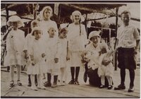
Lees Family [03]
P0005 C. Lowell Lees Photograph Collection
P0005n06_25_003
127
Lees Family [05]
P0005 C. Lowell Lees Photograph Collection
P0005n06_25_005
128
Lees Family [06]
P0005 C. Lowell Lees Photograph Collection
P0005n06_25_006
129
Dog [01]
P0005 C. Lowell Lees Photograph Collection
P0005n06_25_009
130
Dog [02]
P0005 C. Lowell Lees Photograph Collection
P0005n06_25_010
131
Lees Family [11]
P0005 C. Lowell Lees Photograph Collection
P0005n06_25_014
132
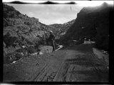
Little Creek Canyon road
P0008 Mark A. Pendleton Photograph Collection
P0008n01_10_090
133
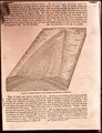
Generalized diagram showing relations of the formations near Silver Reef
P0008 Mark A. Pendleton Photograph Collection
P0008n01_10_094
134
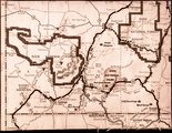
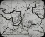
Map of southwestern Utah
P0008 Mark A. Pendleton Photograph Collection
P0008n01_10_095
135
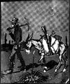
Illustration of a miner and his pack mule
P0008 Mark A. Pendleton Photograph Collection
P0008n01_10_096
136
Map of southwestern Utah
P0008 Mark A. Pendleton Photograph Collection
P0008n01_11_097
137
Colorado River looking up stream from the mouth of Moki Canyon.
P0013 Herbert E. Gregory Photograph Collection
P0013n10_003_2095
138
Colorado River looking down stream from the mouth of Moki Canyon (at the left).
P0013 Herbert E. Gregory Photograph Collection
P0013n10_004_2096
139
Mouth of Moki Canyon. Colorado River would be at the right.
P0013 Herbert E. Gregory Photograph Collection
P0013n10_005_2097
140
Looking into Moki Canyon 25 mi. up from the mouth. It is the only entrance except a trail nearby and one at the head. There is no way to get into the canyon between this point and the mouth 25 mi. below.
P0013 Herbert E. Gregory Photograph Collection
P0013n10_005_2098
141
Wash of Virgin River at Grafton, 30 feet wide in 1860, now 1000 feet wide, Moenkopi forms banks, Navajo beyond, Washington County, Utah, 1930.
P0013 Herbert E. Gregory Photograph Collection
P0013n10_057_2188
142
The Watchman at the mouth of Zion Canyon.
P0013 Herbert E. Gregory Photograph Collection
P0013n10_058_2189
143
The Great White Throne, Zion Canyon.
P0013 Herbert E. Gregory Photograph Collection
P0013n10_059_2190
144
Waterfall from hanging valley during rain storm. Temple of Sinawava, Zion Canyon.
P0013 Herbert E. Gregory Photograph Collection
P0013n10_059_2191
145
Village of Hurricane, Utah, from Hurricane Hill. Cinder cones in middle distance. Pine Valley Mountain on horizon. Fertility in foreground.
P0013 Herbert E. Gregory Photograph Collection
P0013n10_062_2193
146
Old abandoned cotton mill at Washington, Utah.
P0013 Herbert E. Gregory Photograph Collection
P0013n10_062_2194
147
View of the Virgin River a few miles below the mouth of Zion Canyon, showing washed-out banks where farms once stood. Village of Grafton on the opposite side was once the center of a farming area.
P0013 Herbert E. Gregory Photograph Collection
P0013n10_063_2195
148
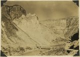
View from the top of the Hurricane Fault (La Verkin Hill), showing Pine Valley Mountain in the distance; the Vermillion Cliff formation in the middle distance, which is the same formation as Zion only much lower on the west side of the Hurricane Fault.
P0013 Herbert E. Gregory Photograph Collection
P0013n10_063_2196
149
View of a branch of the Hurricane Fault showing tilted block on the left which tipped over between the forks with the main fault. Visible from highway at the summit of La Verkin Hill. Lava flow on top and sides of tilted block on left side of picture.
P0013 Herbert E. Gregory Photograph Collection
P0013n10_064_2197
150
The Hurricane Fault where it crosses the Virgin River. La Verkin Warm Sulphur Springs in canyon.
P0013 Herbert E. Gregory Photograph Collection
P0013n10_064_2198
126
-
150
of
4,549
<
1
2
3
4
5
6
7
8
9
10
>