|
|
Title | Collection Number And Name | Photo Number |
| 226 |
 |
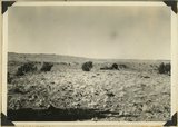
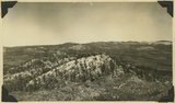
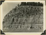
Rim of canyon at Cedar Breaks, Wasatch formation, Iron County, Utah, 1937. | P0013 Herbert E. Gregory Photograph Collection | P0013n10_209_2465 |
| 227 |
 |
Source of the Virgin River. Looking northwest along Cascade Falls Trail. Spring issues from Wasatch limestone cliffs of Markagunt Plateau. Garfield County, Utah, 1937. | P0013 Herbert E. Gregory Photograph Collection | P0013n10_211_2468 |
| 228 |
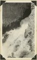 |
Cascade Falls, source of Virgin River. Point of emergence from Wasatch limestone. Garfield County, Utah, 1937. | P0013 Herbert E. Gregory Photograph Collection | P0013n10_211_2469 |
| 229 |
 |
Head of the Fremont River Gorge in Capitol Reef at Fruita, Wayne County, Utah, 1937. | P0013 Herbert E. Gregory Photograph Collection | P0013n10_212_2470 |
| 230 |
 |
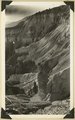
View northwest along Capitol Reef from top of shale slope near Mulford Ranch. Chinle and Wingate (right), river terrace (left). Wayne County, Utah, 1937. | P0013 Herbert E. Gregory Photograph Collection | P0013n10_212_2471 |
| 231 |
 |
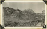
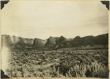
Capitol Reef, looking SE down Sand Creek from point two miles west of Fruita. Moenkopi foreground; Shinarump-Navajo in cliffs; Henry Mountains in distance. Wayne County, Utah, 1937. | P0013 Herbert E. Gregory Photograph Collection | P0013n10_213_2472 |
| 232 |
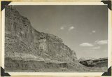 |
View down Fremont Gorge, in Capitol Reef. Left: Moenkopi, Chinle shales, talus slope and cliffs of Wingate. Right: Fruita, river terraces, cliffs of Wingate and high bumps of Navajo sandstone. Wayne County, Utah, 1937. | P0013 Herbert E. Gregory Photograph Collection | P0013n10_213_2473 |
| 233 |
 |
View looking NE along back-slope of Capitol Reef: Fremont River gorge and terraces, upper left; Capitol Wash in middle distance jointing Pleasant Creek at left; lava boulder terrace in foreground. Wayne County, Utah, 1937. | P0013 Herbert E. Gregory Photograph Collection | P0013n10_215_2476 |
| 234 |
 |
The back slopes of Capitol Reef, viewed from the summit of the Fruita-Cainesville road 1/2 mile west of Pleasant Creek. Navajo, Carmel, and red gypsiferous shale above the Carmel in middle foreground, crest of roof on horizon. Wayne County, Utah, 1937. | P0013 Herbert E. Gregory Photograph Collection | P0013n10_215_2477 |
| 235 |
 |
Basalt in Moenkopi, north wash. | P0013 Herbert E. Gregory Photograph Collection | P0013n10_217_2479 |
| 236 |
 |
Elkheart Cliffs east of Mt. Carmel. | P0013 Herbert E. Gregory Photograph Collection | P0013n10_218_2480 |
| 237 |
 |
Same as 191 (Looking north across Orderville, Sevier fault), taken nearer Orderville. | P0013 Herbert E. Gregory Photograph Collection | P0013n10_218_2481 |
| 238 |
 |
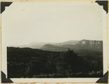
View NE across head of Kanab valley. Left, tilted Tertiary west of Sevier fault; right, Alton Cirque (lowland), above it, Pink Cliffs. | P0013 Herbert E. Gregory Photograph Collection | P0013n10_219_2482 |
| 239 |
 |
West edge Kolob plateau from New Harmony road. | P0013 Herbert E. Gregory Photograph Collection | P0013n10_219_2483 |
| 240 |
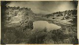 |
One of "Three Lakes," Kanab Canyon. | P0013 Herbert E. Gregory Photograph Collection | P0013n10_220_2484 |
| 241 |
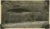 |
Cliff dweller niche, base of Navajo sandstone. Zion Park. | P0013 Herbert E. Gregory Photograph Collection | P0013n10_221_2486 |
| 242 |
 |
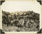
Eagle Crags. | P0013 Herbert E. Gregory Photograph Collection | P0013n10_221_2487 |
| 243 |
 |
Carmel on Navajo. Head of Parunuweap Canyon. | P0013 Herbert E. Gregory Photograph Collection | P0013n10_223_2488 |
| 244 |
 |
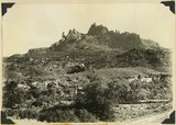
Coalpits volcano north of Grafton. | P0013 Herbert E. Gregory Photograph Collection | P0013n10_223_2489 |
| 245 |
 |
Volcano on Kolob plateau. | P0013 Herbert E. Gregory Photograph Collection | P0013n10_223_2490 |
| 246 |
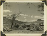 |
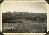
Remains of old town of Paria. | P0013 Herbert E. Gregory Photograph Collection | P0013n10_224_2491 |
| 247 |
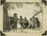 |
Mangum family with Herbert E. Gregory, Paria. | P0013 Herbert E. Gregory Photograph Collection | P0013n10_224_2492 |
| 248 |
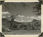 |
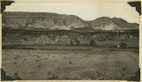
The village of Paria, abandoned. Kane County, UT, 1937 | P0013 Herbert E. Gregory Photograph Collection | P0013n11_006_2537 |
| 249 |
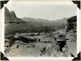 |
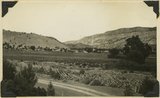
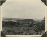
Site of Springdale, Virgin River Valley, below mouth of Zion Canyon. At left, the Watchman. Navajo sandstone, underlaid by Chinle: middle cliff is Springdale member. Washington County, UT | P0013 Herbert E. Gregory Photograph Collection | P0013n11_007_2538 |
| 250 |
 |
Contact Carmel limestone (top) and Navajo (bottom), between them calcareous and argillaceous shales. Kane County, UT | P0013 Herbert E. Gregory Photograph Collection | P0013n11_008_2539 |