Home
Browse
Ask Us
Chat
Harmful Language Statement
Log in
Photo Archives
Advanced Search
About
Over 70,000 photos covering a variety of topics from Marriott Library Special Collections
Year
1930
1931
1932
1933
1934
1935
1936
1937
1938
TO
1930
1931
1932
1933
1934
1935
1936
1937
1938
Type
Image
151
Format
image/jpeg
151
Collection Name
Herbert E. Gregory
151
Filters:
Collection Name:
"Herbert E. Gregory"
Date:
"1937"
Format:
"image/jpeg"
Collection:
"uum_map"
1
-
25
of
151
<
1
2
3
4
5
6
7
>
Gallery view
Number of results to display per page
10
25
50
100
200
Sort by Relevance
Sort by Title A-Z
Sort by Title Z-A
Sort by Date Ascending
Sort by Date Descending
Sort by Last Modified Ascending
Sort by Last Modified Descending
Sort by Photo Number
Title
Collection Number And Name
Photo Number
1
Colorado River looking up stream from the mouth of Moki Canyon.
P0013 Herbert E. Gregory Photograph Collection
P0013n10_003_2095
2
Colorado River looking down stream from the mouth of Moki Canyon (at the left).
P0013 Herbert E. Gregory Photograph Collection
P0013n10_004_2096
3
Mouth of Moki Canyon. Colorado River would be at the right.
P0013 Herbert E. Gregory Photograph Collection
P0013n10_005_2097
4
Looking into Moki Canyon 25 mi. up from the mouth. It is the only entrance except a trail nearby and one at the head. There is no way to get into the canyon between this point and the mouth 25 mi. below.
P0013 Herbert E. Gregory Photograph Collection
P0013n10_005_2098
5
Wash of Virgin River at Grafton, 30 feet wide in 1860, now 1000 feet wide, Moenkopi forms banks, Navajo beyond, Washington County, Utah, 1930.
P0013 Herbert E. Gregory Photograph Collection
P0013n10_057_2188
6
The Watchman at the mouth of Zion Canyon.
P0013 Herbert E. Gregory Photograph Collection
P0013n10_058_2189
7
The Great White Throne, Zion Canyon.
P0013 Herbert E. Gregory Photograph Collection
P0013n10_059_2190
8
Waterfall from hanging valley during rain storm. Temple of Sinawava, Zion Canyon.
P0013 Herbert E. Gregory Photograph Collection
P0013n10_059_2191
9
Village of Hurricane, Utah, from Hurricane Hill. Cinder cones in middle distance. Pine Valley Mountain on horizon. Fertility in foreground.
P0013 Herbert E. Gregory Photograph Collection
P0013n10_062_2193
10
Old abandoned cotton mill at Washington, Utah.
P0013 Herbert E. Gregory Photograph Collection
P0013n10_062_2194
11
View of the Virgin River a few miles below the mouth of Zion Canyon, showing washed-out banks where farms once stood. Village of Grafton on the opposite side was once the center of a farming area.
P0013 Herbert E. Gregory Photograph Collection
P0013n10_063_2195
12
View from the top of the Hurricane Fault (La Verkin Hill), showing Pine Valley Mountain in the distance; the Vermillion Cliff formation in the middle distance, which is the same formation as Zion only much lower on the west side of the Hurricane Fault.
P0013 Herbert E. Gregory Photograph Collection
P0013n10_063_2196
13
View of a branch of the Hurricane Fault showing tilted block on the left which tipped over between the forks with the main fault. Visible from highway at the summit of La Verkin Hill. Lava flow on top and sides of tilted block on left side of picture.
P0013 Herbert E. Gregory Photograph Collection
P0013n10_064_2197
14
The Hurricane Fault where it crosses the Virgin River. La Verkin Warm Sulphur Springs in canyon.
P0013 Herbert E. Gregory Photograph Collection
P0013n10_064_2198
15
Shale formation where fossils are found. Near the Pine Creek bridge at the base of the switchboard on new Mt. Carmel road, Zion Canyon.
P0013 Herbert E. Gregory Photograph Collection
P0013n10_065_2199
16
The Virgin Mesa from top of Hurricane Hill.
P0013 Herbert E. Gregory Photograph Collection
P0013n10_066_2200
17
Virgin Mesa from highway below Rockville, Utah.
P0013 Herbert E. Gregory Photograph Collection
P0013n10_066_2201
18
Crossbedding of sandstone along Mt. Carmel road. Indicating wind action and sand dune formation prior to the formation of rock.
P0013 Herbert E. Gregory Photograph Collection
P0013n10_067_2202
19
Curvillinear fractures in sandstone, west wall of Temple of Sinawava, Zion Canyon.
P0013 Herbert E. Gregory Photograph Collection
P0013n10_068_2203
20
Wind and water erosion in sandstone. In Zion Canyon on west side of the Virgin River, about one-half mile above checking station.
P0013 Herbert E. Gregory Photograph Collection
P0013n10_069_2204
21
Half Arch. East side of Narrows, Zion Canyon, above Temple of Sinawava.
P0013 Herbert E. Gregory Photograph Collection
P0013n10_070_2205
22
Hidden Canyon from Observation Point. A typical hanging canyon or valley.
P0013 Herbert E. Gregory Photograph Collection
P0013n10_071_2206
23
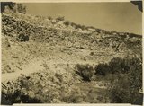
Volcanic cone, two miles west of Hurricane, Utah.
P0013 Herbert E. Gregory Photograph Collection
P0013n10_071_2207
24
Lava flow over gravel wash. South of Toquerville, Utah, along main road from Zion Canyon to Anderson's Ranch.
P0013 Herbert E. Gregory Photograph Collection
P0013n10_072_2208
25
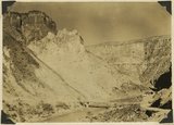
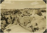
View southwest toward the rim of Bryce Canyon from the north side of lower canyon near the Fairy Temple trail.
P0013 Herbert E. Gregory Photograph Collection
P0013n10_074_2209
1
-
25
of
151
<
1
2
3
4
5
6
7
>