Home
Browse
Ask Us
Chat
Harmful Language Statement
Log in
Photo Archives
Advanced Search
About
Over 70,000 photos covering a variety of topics from Marriott Library Special Collections
Year
1950
1951
1952
1953
1954
1955
1956
1957
1958
1959
1960
1961
1962
1963
1964
1965
1966
1967
1968
1969
1970
1971
1972
1973
1974
1975
TO
1950
1951
1952
1953
1954
1955
1956
1957
1958
1959
1960
1961
1962
1963
1964
1965
1966
1967
1968
1969
1970
1971
1972
1973
1974
1975
Type
Image
594
Format
image/jpeg
594
Collection
Photo Archives
594
Filters:
Collection Name:
"John Stockert"
526
-
550
of
594
<
15
16
17
18
19
20
21
22
23
24
>
Gallery view
Number of results to display per page
10
25
50
100
200
Sort by Relevance
Sort by Title A-Z
Sort by Title Z-A
Sort by Date Ascending
Sort by Date Descending
Sort by Last Modified Ascending
Sort by Last Modified Descending
Title
Date
Type
526
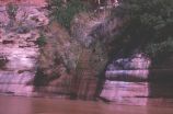
Seep across river from camp, one of many along Escalante River
1963-04-23
Image
527
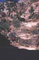
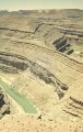
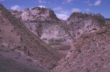
Side canyon from highway in Zion National Park
1974-04-16
Image
528
Side canyon, along Cottonwood Wash Road, southern Utah
1973-05
Image
529
Side view of Roost Arch from upstream, Davis Canyon
1963-04-23
Image
530
Sign about the Cockscomb formation, Cottonwood Canyon, Kane County, Utah
1973-05
Image
531
Sign at Crossing of the Fathers, Gunsight Butte in background
1963-03-14
Image
532
Sign showing the entrance to Sheep Creek Canyon Geological Area in the Ashley National Forest.
1968-10-19
Image
533
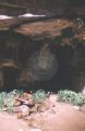
Sipapu Natural Bridge, Natural Bridges National Monument
1960-10-11
Image
534
Sketch of a Native American Village
1966-07-25
Image
535
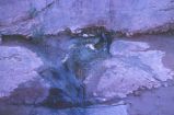
Small cascade from a small gulch near gaging station and trail down
1963-04-24
Image
536
South from Angels Landing trailhead
1959-06-24
Image
537
Southern Utah scenery
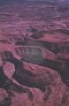
1963
Image
538
Southern Utah scenery
1963
Image
539
Southern Utah scenery
1960-06-12
Image
540
Southern Utah scenery
1960-06-12
Image
541
Spanish Valley near Moab [1]
1960-10
Image
542
Spring on road between Hites Ferry and Henry Mountains
1963-06-26
Image
543
Steep mountains along Cottonwood Wash road, southern Utah
1963-04-21
Image
544
Steep rock slope along trail from mesa to Escalante River
1963-04-22
Image
545
Steve Jet and pack mule near cattle(?) bones on trail to Escalante River
1963-04-22
Image
546
Stockert family along Green River below Flaming Gorge Dam
1968-10-19
Image
547
Stockert family at Flaming Gorge reservoir.
1968-10-19
Image
548
Stop to gas up on stormy Lake Powell
1963-04-26
Image
549
Storm in Zion Canyon [1]
1970-11-26
Image
550
Storm in Zion Canyon [2]
1970-11-26
Image
526
-
550
of
594
<
15
16
17
18
19
20
21
22
23
24
>