|
|
Title | Collection Number And Name | Photo Number |
| 151 |
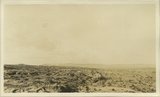 |
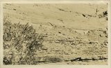
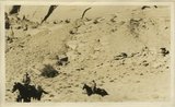
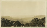
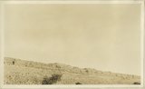
Plain developed on top of Castle uplift, San Juan County, UT 1925 | P0013 Herbert E. Gregory Photograph Collection | P0013n09_041_1798 |
| 152 |
 |
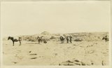
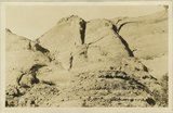
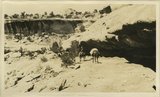
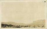
Camp on Navajo sandstone east of Castle uplift, San Juan County, UT, 1925 | P0013 Herbert E. Gregory Photograph Collection | P0013n09_042_1799 |
| 153 |
 |
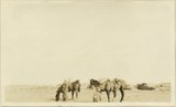
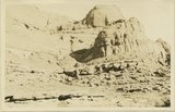
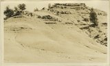
Waterpockets in Navajo sandstone near Castle uplift. San Juan County, UT, 1925 | P0013 Herbert E. Gregory Photograph Collection | P0013n09_042_1800 |
| 154 |
 |
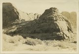
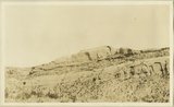
Waterpockets in Navajo sandstone near Castle uplift. San Juan County, UT, 1925 | P0013 Herbert E. Gregory Photograph Collection | P0013n09_043_1801 |
| 155 |
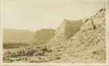 |
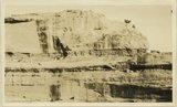
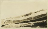
Walls of Castle Canyon showing Todilto and Navajo. San Juan County, UT, 1925 | P0013 Herbert E. Gregory Photograph Collection | P0013n09_043_1802 |
| 156 |
 |
Walls of Castle Canyon showing Todilto and Navajo. San Juan County, UT, 1925 | P0013 Herbert E. Gregory Photograph Collection | P0013n09_044_1803 |
| 157 |
 |
Walls of Castle Canyon showing Todilto and Navajo. San Juan County, UT, 1925 | P0013 Herbert E. Gregory Photograph Collection | P0013n09_044_1804 |
| 158 |
 |
Walls of Castle Canyon showing Todilto and Navajo. San Juan County, UT, 1925 | P0013 Herbert E. Gregory Photograph Collection | P0013n09_045_1805 |
| 159 |
 |
Walls of Castle Canyon showing Todilto and Navajo. San Juan County, UT, 1925 | P0013 Herbert E. Gregory Photograph Collection | P0013n09_045_1806 |
| 160 |
 |
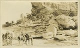
Trail on Todilto at base of Walls of Navajo. Castle Canyon. San Juan County, UT, 1925 | P0013 Herbert E. Gregory Photograph Collection | P0013n09_046_1807 |
| 161 |
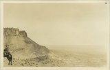 |
Crest of Clay Hills Divide cut in Chinle strata: looking east toward Grand Gulch. San Juan County, UT, 1925 | P0013 Herbert E. Gregory Photograph Collection | P0013n09_046_1808 |
| 162 |
 |
Crest of Clay Hills Divide cut in Chinle strata: looking east toward Grand Gulch. San Juan County, UT, 1925 | P0013 Herbert E. Gregory Photograph Collection | P0013n09_047_1809 |
| 163 |
 |
Walls of White Canyon showing forms resulting from erosion of red shale like bands which occur as lenses in massive crossed white Coconino sandstone. San Juan County, UT, 1925 | P0013 Herbert E. Gregory Photograph Collection | P0013n09_047_1810 |
| 164 |
 |
Walls of White Canyon showing forms resulting from erosion of red shale like bands which occur as lenses in massive crossed white Coconino sandstone. San Juan County, UT, 1925 | P0013 Herbert E. Gregory Photograph Collection | P0013n09_048_1811 |
| 165 |
 |
Walls of White Canyon showing forms resulting from erosion of red shale like bands which occur as lenses in massive crossed white Coconino sandstone. San Juan County, UT, 1925 | P0013 Herbert E. Gregory Photograph Collection | P0013n09_048_1812 |
| 166 |
 |
Walls of White Canyon showing forms resulting from erosion of red shale like bands which occur as lenses in massive crossed white Coconino sandstone. San Juan County, UT, 1925 | P0013 Herbert E. Gregory Photograph Collection | P0013n09_049_1813 |
| 167 |
 |
Walls of White Canyon showing forms resulting from erosion of red shale like bands which occur as lenses in massive crossed white Coconino sandstone. San Juan County, UT, 1925 | P0013 Herbert E. Gregory Photograph Collection | P0013n09_049_1814 |
| 168 |
 |
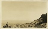
Head of White Canyon looking NW. Canyon floor developed in Kaibab, sides in Moenkopi capped by Shinarump. Distant mesas of Navajo. San Juan County, UT, 1925 | P0013 Herbert E. Gregory Photograph Collection | P0013n09_050_1815 |
| 169 |
 |
Bears Ears views from the south cliffs are Chinle, capped by Wingate, foreground is Shinarump. Elk Ridge, San Juan County, UT, 1925 | P0013 Herbert E. Gregory Photograph Collection | P0013n09_050_1816 |
| 170 |
 |
Bears Ears views from the south cliffs are Chinle, capped by Wingate, foreground is Shinarump. Elk Ridge, San Juan County, UT, 1925 | P0013 Herbert E. Gregory Photograph Collection | P0013n09_051_1817 |
| 171 |
 |
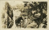
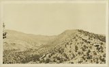
Allen Canyon country outer slope of Comb monocline. San Juan County, UT, 1925. Wall of ridge includes Moenkopi and Chinle, head of Whiskers Creek | P0013 Herbert E. Gregory Photograph Collection | P0013n09_051_1818 |
| 172 |
 |
Allen Canyon country outer slope of Comb monocline. San Juan County, UT, 1925. Wall of ridge includes Moenkopi and Chinle, head of Whiskers Creek | P0013 Herbert E. Gregory Photograph Collection | P0013n09_052_1819 |
| 173 |
 |
East wall of Comb Wash includes Chinle, Wingate, Todilto, Navajo near mouth of Arch Canyon. San Juan County, UT. 1925 | P0013 Herbert E. Gregory Photograph Collection | P0013n09_052_1820 |
| 174 |
 |
Top of wall east side of Comb Wash. Strata of Glen Canyon Group near mouth of Arch Canyon. San Juan County, UT, 1925 | P0013 Herbert E. Gregory Photograph Collection | P0013n09_053_1821 |
| 175 |
 |
Comb monocline left Kaibab, valley floor and end Moenkopi. Shinarump right. Chinle slopes capped by Wingate. Shinarump caps Elk Ridge high point in left background. View looking north from mouth of Arch Canyon. San Juan County, UT, 1925 | P0013 Herbert E. Gregory Photograph Collection | P0013n09_053_1822 |