Over 70,000 photos covering a variety of topics from Marriott Library Special Collections
TO
| Title | Date | Type | ||
|---|---|---|---|---|
| 1 |
 |
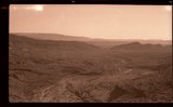
Barbee and Walker mine and Mill site on west side of reef, circa 1928 | 1927; 1928; 1929; 1930 | Image/StillImage |
| 2 |
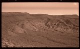 |
Barren landscape, Washington County: Panorama, part one | 1927; 1928; 1929; 1930 | Image/StillImage |
| 3 |
 |
Barren landscape, Washington County: Panorama, part three | 1927; 1928; 1929; 1930 | Image/StillImage |
| 4 |
 |
Barren landscape, Washington County: Panorama, part two | 1927; 1928; 1929; 1930 | Image/StillImage |
| 5 |
 |
Christy Mining and Milling Company offices at Silver Reef, Utah, ca 1928 | 1927; 1928; 1929; 1930 | Image/StillImage |
| 6 |
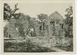 |
Christy Mining and Milling Company offices at Silver Reef, Utah, ca 1928 | 1927; 1928; 1929; 1930 | Image/StillImage |
| 7 |
 |
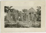
Christy Mining and Milling Company offices. Mark A. Pendleton on left. Silver Reef, circa 1928 | 1927; 1928; 1929; 1930 | Image/StillImage |
| 8 |
 |
Ensign Peak monument | 1920; 1921; 1922; 1923; 1924; 1925; 1926; 1927; 1928; 1929; 1930 | Image/StillImage |
| 9 |
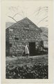
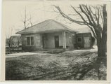
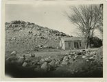 |
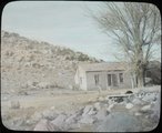
Entering Leeds, Utah, from the north: an old time home | 1927; 1928; 1929; 1930 | Image/StillImage |
| 10 |
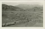 |
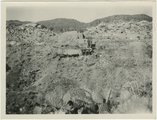
General view of Silver Reef, Utah area looking west from Leeds. Pine Valley Mountains in background. | 1927; 1928; 1929; 1930 | Image/StillImage |
| 11 |
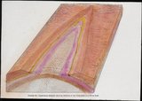 |
Generalized diagram showing relations of the formations near Silver Reef | 1927; 1928; 1929; 1930 | Image/StillImage |
| 12 |
 |
Generalized diagram showing relations of the formations near Silver Reef | 1925; 1926; 1927; 1928; 1929; 1930; 1931; 1932; 1933; 1934; 1935; 1936; 1937; 1938; 1939; 1940 | Image/StillImage |
| 13 |
 |
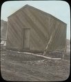
Gin house at Toquerville | 1920; 1921; 1922; 1923; 1924; 1925; 1926; 1927; 1928; 1929; 1930 | Image/StillImage |
| 14 |
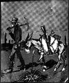 |
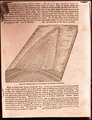
Illustration of a miner and his pack mule | 1925; 1926; 1927; 1928; 1929; 1930; 1931; 1932; 1933; 1934; 1935; 1936; 1937; 1938; 1939; 1940 | Image/StillImage |
| 15 |
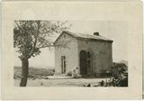
 |
John H. Rice Bank Building, Silver Reef, circa 1928. | 1927; 1928; 1929; 1930 | Image/StillImage |
| 16 |
 |
John H. Rice bank building, Silver Reef, Utah ca. 1928 | 1927; 1928; 1929; 1930 | Image/StillImage |
| 17 |
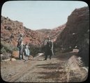
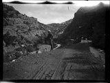 |
Little Creek Canyon road | 1925; 1926; 1927; 1928; 1929; 1930; 1931; 1932; 1933; 1934; 1935; 1936; 1937; 1938; 1939; 1940 | Image/StillImage |
| 18 |
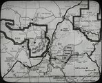 |
Map of southwestern Utah | 1925; 1926; 1927; 1928; 1929; 1930; 1931; 1932; 1933; 1934; 1935; 1936; 1937; 1938; 1939; 1940 | Image/StillImage |
| 19 |
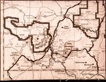 |
Map of southwestern Utah | 1925; 1926; 1927; 1928; 1929; 1930; 1931; 1932; 1933; 1934; 1935; 1936; 1937; 1938; 1939; 1940 | Image/StillImage |
| 20 |
 |
Mark A. Pendleton in middle of road at Little Creek near Paragonah, circa 1940. This was the route of an Indian raiding ? party in pioneer times | 1927; 1928; 1929; 1930 | Image/StillImage |
| 21 |
 |
Mrs Margaret Grambs' restaurant at Leeds, Utah. | 1927; 1928; 1929; 1930 | Image/StillImage |
| 22 |
 |
Old dwelling at Leeds, circa 1928 | 1927; 1928; 1929; 1930 | Image/StillImage |
| 23 |
 |
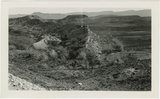
Old mine and mill site (Barbee & Walker?) on west side of Silver Reef gulch ca. 1928 | 1927; 1928; 1929; 1930 | Image/StillImage |
| 24 |
 |
Old Silver Reef jail trasported to Sterlings field in Leeds, used as an ice house | 1927; 1928; 1929; 1930 | Image/StillImage |
| 25 |
 |
One of old mines at Silver Reef, Utah, ca 1928 | 1927; 1928; 1929; 1930 | Image/StillImage |