Home
Browse
Ask Us
Chat
Harmful Language Statement
Log in
Advanced Search
Year
1872
1873
1874
1875
1876
1877
1878
1879
1880
1881
1882
1883
1884
1885
1886
1887
1888
1889
1890
1891
1892
1893
1894
1895
1896
1897
1898
1899
1900
1901
1902
1903
1904
1905
1906
1907
1908
1909
1910
1911
1912
1913
1914
1915
1916
1917
1918
1919
1920
1921
1922
1923
1924
1925
1926
1927
1928
1929
1930
1931
1932
1933
1934
1935
1936
1937
1938
1939
1940
1941
1942
1943
1944
1945
1946
1947
1948
1949
1950
1951
1952
1953
1954
1955
1956
1957
1958
1959
1960
1961
1962
1963
1964
1965
1966
1967
1968
1969
1970
1971
1972
1973
1974
1975
1976
1977
1978
1979
1980
1981
1982
1983
1984
1985
1986
1987
1988
1989
1990
1991
1992
1993
TO
1872
1873
1874
1875
1876
1877
1878
1879
1880
1881
1882
1883
1884
1885
1886
1887
1888
1889
1890
1891
1892
1893
1894
1895
1896
1897
1898
1899
1900
1901
1902
1903
1904
1905
1906
1907
1908
1909
1910
1911
1912
1913
1914
1915
1916
1917
1918
1919
1920
1921
1922
1923
1924
1925
1926
1927
1928
1929
1930
1931
1932
1933
1934
1935
1936
1937
1938
1939
1940
1941
1942
1943
1944
1945
1946
1947
1948
1949
1950
1951
1952
1953
1954
1955
1956
1957
1958
1959
1960
1961
1962
1963
1964
1965
1966
1967
1968
1969
1970
1971
1972
1973
1974
1975
1976
1977
1978
1979
1980
1981
1982
1983
1984
1985
1986
1987
1988
1989
1990
1991
1992
1993
Type
Image
3,521
Image/StillImage
143
Format
image/jpeg
3,594
application/pdf
70
Collection
Photo Archives
3,521
UAIDA Main Collection
143
Filters:
Collection Name:
"Herbert E. Gregory"
401
-
425
of
3,664
<
12
13
14
15
16
17
18
19
20
21
>
Gallery view
Number of results to display per page
10
25
50
100
200
Sort by Relevance
Sort by Title A-Z
Sort by Title Z-A
Sort by Date Ascending
Sort by Date Descending
Sort by Last Modified Ascending
Sort by Last Modified Descending
Title
Date
Type
Setname
401
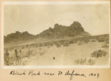
Black Rock near Ft. Defiance, 1909
1909
Image
uum_map
402
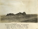
Black Rock, Ft. Defiance, Ariz. Dike of diabase. Looking east. La Plata sandstone in distance. Detailed structure, 1909 (photo G-14)
1909
Image
uum_map
403
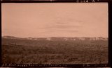
Block mesas from south, panorama.
1937
Image
uum_map
404
Block mesas from south, panorama.
1937
Image
uum_map
405
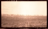
Block mesas from the south, panorama.
1937
Image
uum_map
406
Block Mesas, east of Elephant Gap. Navajo sandstone capped by Carmel. Kane County, Utah, 1936.
1936
Image
uum_map
407
Blue Canyon, Ariz. (negative for G-5)
1909
Image
uum_map
408
Blue Canyon, Ft. Defiance, Ariz. (negative for G-4)
1909
Image
uum_map
409
Blue Canyon, looking north, 1914
1914
Image
uum_map
410
Blue Canyon, looking toward Black Mesa. McElmo sandstone capped by Mancos in middle distance, 1914
1914
Image
uum_map
411
Blue Springs meadow at Leigh ranch. Stream from big springs (lower left) meanders across an ancient lake bed and escapes through a water gap (center distance). Garfield County, UT, 1944
1944
Image
uum_map
412
Bluff and Twins looking southwest across San Juan River (W.H. Hopkins)
1928
Image
uum_map
413
Bluff at Bluff, UT
1925
Image
uum_map
414
Bluff on the Moab road about 43 miles north of Monticello, Utah, showing LaPlata sandstone and McElmo formation. The upper La plata is about 200 feet thick and the lower La plata, the top of which is seen here, is about 300 feet, these sandstones are separated by red, shaly crinkled material. Lee, 1925.
1925
Image
uum_map
415
Bluff sandstone (Entrada) underlain by red beds (Carmel) on the south side of San Juan River a short distance west of Bluff. Note thin bedding in lower part of Bluff sandstone near right side of view
1927
Image
uum_map
416
Bluff sandstone (Morrison) 3 miles west of Bluff, San Juan County, Utah, 1932.
1932
Image
uum_map
417
Bluff sandstone and underlying beds at head of Butler Wash, San Juan County, Utah, 1929.
1929
Image
uum_map
418
Bluff sandstone and underlying beds at Reservoir, 1 mile west of Bluff, San Juan County, Utah, 1929.
1929
Image
uum_map
419
Bluff sandstone surrounded by alluvian terraced by recent down cutting.Cottonwood Wash in foreground. Diecker Ranch, San Juan County, Utah, 1932.
1932
Image
uum_map
420
Bluff sandstone, San Juan Co., Ut., 1929
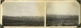
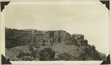
1929
Image
uum_map
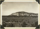
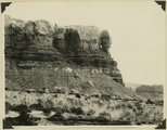
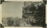
421
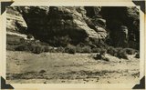
Bluffs at Bluff, UT
1920; 1921; 1922; 1923; 1924; 1925; 1926; 1927; 1928; 1929; 1930
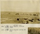
Image
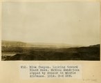
uum_map
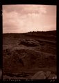
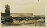
422
Boat, Lake Titicaca.
1912; 1913; 1914; 1915
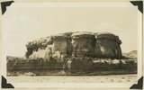
Image
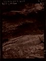
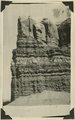
uum_map
423
Bondi Beach, N.S.W.
1916
Image
uum_map
424
Bottom of Glen Canyon group. Color banded cross-bed sandstone in positions of Wingate, Rosencrans Wash, Mohave County, Arizona, 1936.
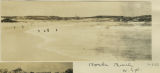
1936
Image
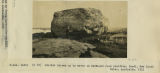
uum_map
425
Boulder thrown up by waves on the wave-cut rock platform, Bondi, New South Wales, Australia, 1916
1916
Image
uum_map
401
-
425
of
3,664
<
12
13
14
15
16
17
18
19
20
21
>