|
|
Title | Collection Number And Name | Photo Number |
| 101 |
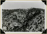 |
Undifferentiated Cretaceous formation near mouth of Parowan Canyon. Iron County, UT | P0013 Herbert E. Gregory Photograph Collection | P0013n11_165_2785 |
| 102 |
 |
Fault, Wasatch limestone (extreme right) in horizontal contact with undifferentiated Cretaceous. Parowan Canyon. Iron County, UT | P0013 Herbert E. Gregory Photograph Collection | P0013n11_166_2786 |
| 103 |
 |
Fault, Wasatch limestone (extreme right) in horizontal contact with undifferentiated Cretaceous. Parowan Canyon. Iron County, UT | P0013 Herbert E. Gregory Photograph Collection | P0013n11_166_2787 |
| 104 |
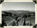 |
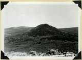
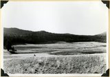
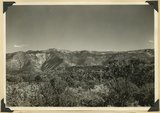
Summit Ridge. View looking south across Braffitts Canyon. Iron County, UT | P0013 Herbert E. Gregory Photograph Collection | P0013n11_167_2788 |
| 105 |
 |
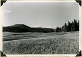
Summit Ridge. Undissected highland 9000 feet near head of Summit Canyon, Iron County | P0013 Herbert E. Gregory Photograph Collection | P0013n11_167_2789 |
| 106 |
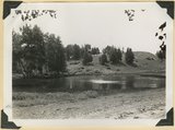 |
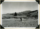
Summit Ridge. Pond supplied chiefly by melting snow. Iron County | P0013 Herbert E. Gregory Photograph Collection | P0013n11_168_2790 |
| 107 |
 |
Summit Ridge. Pond supplied chiefly by melting snow. Iron County | P0013 Herbert E. Gregory Photograph Collection | P0013n11_168_2791 |
| 108 |
 |
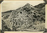
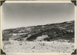
Sugar loaf on outlier of Markagunt Plateau on divide between Parowan and Coal Creek drainage areas. Iron County | P0013 Herbert E. Gregory Photograph Collection | P0013n11_169_2792 |
| 109 |
 |
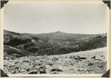
Surface of Kolob Terrace near Pryor Knoll, Iron County | P0013 Herbert E. Gregory Photograph Collection | P0013n11_169_2793 |
| 110 |
 |
Westward tilting Moenkopi strata; Timpoweap, lower red, Virgin and Shnabkaib members. Mouth of Kanarra Canyon. Iron Co, UT | P0013 Herbert E. Gregory Photograph Collection | P0013n11_170_2794 |
| 111 |
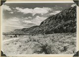 |
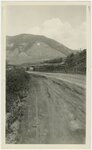
Hurricane Cliffs looking north across mouth of Swayne Creek. Iron County | P0013 Herbert E. Gregory Photograph Collection | P0013n11_170_2795 |
| 112 |
 |
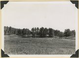
Sidney Valley near head of Castle Creek. Ponds and kame-like accumulation resulting from glaciation. Iron County, UT | P0013 Herbert E. Gregory Photograph Collection | P0013n11_171_2796 |
| 113 |
 |
Sidney Valley near head of Castle Creek. Ponds and kame-like accumulation resulting from glaciation. Iron County, UT | P0013 Herbert E. Gregory Photograph Collection | P0013n11_171_2797 |
| 114 |
 |
Surface of Kolob Terrace near head of Crystal Creek. Developed on Tropic shale | P0013 Herbert E. Gregory Photograph Collection | P0013n11_172_2798 |
| 115 |
 |
Panorama. Surface of Kolob Terrace near the head of Kolob Creek. Iron County, UT | P0013 Herbert E. Gregory Photograph Collection | P0013n11_172_2799 |
| 116 |
 |
Panorama. Surface of Kolob Terrace near the head of Kolob Creek. Iron County, UT | P0013 Herbert E. Gregory Photograph Collection | P0013n11_173_2800 |
| 117 |
 |
View looking north from near head of South Creek across Coal Canyon, Iron County, UT | P0013 Herbert E. Gregory Photograph Collection | P0013n11_173_2801 |
| 118 |
 |
Montana State University, Bozeman Montana [01] | P0029 Joseph Kingsbury Photograph Collection | P0029n01_06_02 |
| 119 |
 |
Montana State University, Bozeman Montana [02] | P0029 Joseph Kingsbury Photograph Collection | P0029n01_06_03 |
| 120 |
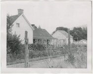 |
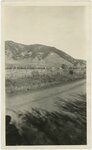
Paragonah, Utah, home of Eliza Edwards Hanks [02] | P0029 Joseph Kingsbury Photograph Collection | P0029n01_06_06 |
| 121 |
 |
Hanks (on envelope) [02] | P0029 Joseph Kingsbury Photograph Collection | P0029n01_07_22 |
| 122 |
 |
Portrait of LeRoy Robertson [01] | P0038 LeRoy Robertson photograph collection, 1945-1960 | P0038n01_01_001 |
| 123 |
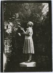 |
Ruth Harwood standing on stool admiring a plant | P0042 Ruth Harwood Photograph Collection, Circa 1900-1950 | P0042n01_01_007 |
| 124 |
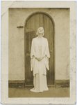 |
Ruth St. Denis in white gown standing in front of wooden door | P0042 Ruth Harwood Photograph Collection, Circa 1900-1950 | P0042n01_02_016 |
| 125 |
 |
Autographed portrait of Ruth St. Denis [1] | P0042 Ruth Harwood Photograph Collection, Circa 1900-1950 | P0042n01_02_017 |