Home
Browse
Ask Us
Chat
Harmful Language Statement
Log in
Photo Archives
Advanced Search
About
Over 70,000 photos covering a variety of topics from Marriott Library Special Collections
Year
1938
1939
1940
1941
1942
TO
1938
1939
1940
1941
1942
Type
Image
52
Format
image/jpeg
51
application/pdf
1
Collection
Photo Archives
52
Filters:
Collection Name:
"Herbert E. Gregory"
Date:
"1941"
1
-
25
of
52
<
1
2
3
>
Gallery view
Number of results to display per page
10
25
50
100
200
Sort by Relevance
Sort by Title A-Z
Sort by Title Z-A
Sort by Date Ascending
Sort by Date Descending
Sort by Last Modified Ascending
Sort by Last Modified Descending
Title
Date
Type
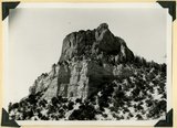
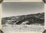
1
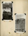
Casto Bluff head of Casto Canyon southwest edge of Sevier Plateau. Acidic lava underlain by Sevier(?) formation, Garfield County, UT, 1941
1941
Image
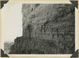
2
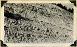
Casto Bluff, detail thick lava beds in Sevier(?) formation
1941
Image
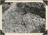
3
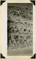
Castro Bluff, detail pumice conglomerate in Sevier formation
1941
Image
4
Castro Bluff, detail thin beds (upper) in Sevier(?) formation
1941
Image
5
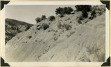
Castro Bluff, view looking westward from its base. Terrace developed in the Sevier(?) formation at the top of the Wasatch formation
1941
Image
6
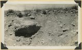
Conglomerates, base of Timpoweep member of the Moenkopi Tarper Creek. Washington County, UT. 1941
1941
Image
7
Contact of Triassic and Permian (beds in wall wrinkled at base). Cherty limestone lower left. Camp Creek. Iron County, UT. 1941
1941
Image
8
Fault, Wasatch limestone (extreme right) in horizontal contact with undifferentiated Cretaceous. Parowan Canyon. Iron County, UT
1941
Image
9
Fault, Wasatch limestone (extreme right) in horizontal contact with undifferentiated Cretaceous. Parowan Canyon. Iron County, UT
1941
Image
10
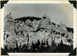
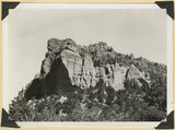
General view of eroded Pink Cliffs (Wasatch formation) near Cedar Breaks, Iron County, UT
1941
Image
11
Glacial till, Castle Creek below Sidney Valley. Top of Markagunt Plateau. Iron County, UT. 1941
1941
Image
12
Herbert E. Gregory Book 11: Colorado Plateau, 1938-1942
1938; 1939; 1940; 1941; 1942
Image
13
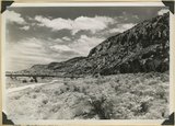
Hurricane Cliffs looking north across mouth of Swayne Creek. Iron County
1941; 1942
Image
14
Kaiparowits formation Cretaceous. Conglomerate (pinnacles) in contact with bedded arkosie sandstone. Parowan Canyon. Iron Co
1941
Image
15
Kaiparowits formation near southwest corner of Cedar Breaks National Monument. Iron County, UT. 1941
1941
Image
16
Kaiparowits formation on Cedar City, Cedar Breaks road above Wood's Ranch. Iron County, UT. 1941
1941
Image
17
Kaiparowits formation unconformable below Wasatch limestone south, foot of Parowan Canyon, Iron County, UT. 1941
1941
Image
18
Kaiparowits formation, head of Deep Creek, Iron County, UT. 1941
1941
Image
19
Mouth of Camp Creek. Resistant limestones of lowest Triassic make walls. Iron County, UT. 1941
1941
Image
20
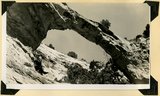
Natural bridge near top of wall of Ashdown Canyon, Iron County, UT, 1941
1941
Image
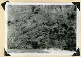
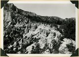
21
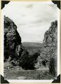
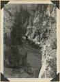
Panorama of Ashdown Canyon, 600-1800 feet deep, 20-150 feet wide out in Straight Cliffs sandstone. Iron County, UT, 1941
1941
Image
22
Panorama of Ashdown Canyon, 600-1800 feet deep, 20-150 feet wide out in Straight Cliffs sandstone. Iron County, UT, 1941
1941
Image
23
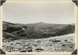
Panorama. Surface of Kolob Terrace near the head of Kolob Creek. Iron County, UT
1941; 1942
Image
24
Panorama. Surface of Kolob Terrace near the head of Kolob Creek. Iron County, UT
1941; 1942
Image
25
Same as 2751, shows eroded top of Sevier Plateau
1941
Image
1
-
25
of
52
<
1
2
3
>