|
|
Title | Collection Number And Name | Photo Number |
| 176 |
 |
Landslides in Chinle near mouth of the Parunuweap, springdale member (right center), Kane County, UT, 1939 | P0013 Herbert E. Gregory Photograph Collection | P0013n11_058_2622 |
| 177 |
 |
Northernmost of three Flax Lakes on high divide between Kanab and Parunuweap Valleys. In Cretaceous beds. Looking northeast across head of Kanab Valley to Pink Cliffs (Tertiary), Kane County, UT. 1939 | P0013 Herbert E. Gregory Photograph Collection | P0013n11_059_2624 |
| 178 |
 |
Flax Lakes (same unit). A branch canyon of Kanab Creek extending toward it, Kane County, UT. 1939 | P0013 Herbert E. Gregory Photograph Collection | P0013n11_060_2625 |
| 179 |
 |
The Steamboat. Shnabkaib (bottom) and upper red level of Moenkopi capped in part by Shinarump 2 miles west of Fredonia, Coconino County, AZ. 1939 | P0013 Herbert E. Gregory Photograph Collection | P0013n11_061_2628 |
| 180 |
 |
The Steamboat. Shnabkaib (bottom) and upper red level of Moenkopi capped in part by Shinarump 2 miles west of Fredonia, Coconino County, AZ. 1939 | P0013 Herbert E. Gregory Photograph Collection | P0013n11_062_2629 |
| 181 |
 |
Ancient gravels, (left center) form terrace both sides of Virgin River between Rockville and Grafton. Rest unconformably on middle Moenkopi beds, upper Moenkopi, Shinarump, Chinle, and Navajo above. Washington County, UT, 1939 | P0013 Herbert E. Gregory Photograph Collection | P0013n11_062_2630 |
| 182 |
 |
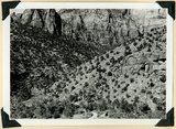
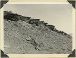
'Elephant feet'. Wingate sandstone, Kayenta above. Three Lakes Canyon, Kane County, UT, 1939 | P0013 Herbert E. Gregory Photograph Collection | P0013n11_063_2631 |
| 183 |
 |
Wingate sandstone, detailed structure. Flat-lying Kayenta above. Caves Lakes Canyon, Kane County, UT. 1939 | P0013 Herbert E. Gregory Photograph Collection | P0013n11_064_2632 |
| 184 |
 |
Wingate sandstone. Same as 2632. Flat-lying Kayenta above. Caves Lakes Canyon, Kane County, UT. 1939 | P0013 Herbert E. Gregory Photograph Collection | P0013n11_065_2633 |
| 185 |
 |
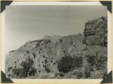
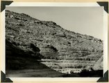
Landslide in Chinle formation from base of Navajo Mountains Sandstone, Springdale member of Chinle (middle right). Near headquarters, Zion National Park, UT. 1939 | P0013 Herbert E. Gregory Photograph Collection | P0013n11_065_2634 |
| 186 |
 |
Joints in Navajo sandstone on Zion-Mt. Carmel road, Kane County, UT. 1939 | P0013 Herbert E. Gregory Photograph Collection | P0013n11_066_2635 |
| 187 |
 |
Joints in Navajo sandstone on Zion-Mt. Carmel road, Kane County, UT. 1939. | P0013 Herbert E. Gregory Photograph Collection | P0013n11_066_2636 |
| 188 |
 |
Northern edge Kanab Plateau. Village of Fredonia on surface eroded from lower Moenkopi beds and crossed by Kanab Creek. Buttes of Moenkopi capped by Shinarump (right), Coconino County, August, 1939 | P0013 Herbert E. Gregory Photograph Collection | P0013n11_067_2637 |
| 189 |
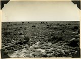 |
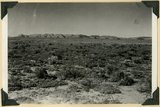
Surface of Uinkaret Plateau southwest of Cane Beds, Mohave County, AZ, Aug. 2, 1939 | P0013 Herbert E. Gregory Photograph Collection | P0013n11_067_2638 |
| 190 |
 |
Lake in Three Lakes Canyon fed from springs in Cane at the base of Navajo sandstone, Kane County, UT. 1939 | P0013 Herbert E. Gregory Photograph Collection | P0013n11_068_2639 |
| 191 |
 |
Eroded alluvial fill 60 feet thick in Kanab Creek. In 1884 stream ran at top of terrace, Kane Co., Utah, 1939 | P0013 Herbert E. Gregory Photograph Collection | P0013n11_068_2640 |
| 192 |
 |
Shinarump and Moenkopi beds disturbed by a local fault 3 miles north of Fredonia, Coconino County, AZ. 1939 | P0013 Herbert E. Gregory Photograph Collection | P0013n11_069_2641 |
| 193 |
 |
Erosion surface on lower Chinle beds at base of Vermillion Cliffs, traversed by Kanab Creek (left center), Kane County, UT. 1939 | P0013 Herbert E. Gregory Photograph Collection | P0013n11_069_2642 |
| 194 |
 |
View looking west toward buttes of Moenkopi capped by lava between Hurricane Cliffs and Workman Wash (foreground). Washington County, UT, 1939 | P0013 Herbert E. Gregory Photograph Collection | P0013n11_071_2643 |
| 195 |
 |
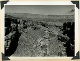
Mouth of Timpoweap Canyon of Virgin River looking east upstream. Kaibab and Moenkopi strata also basalt (upper left). Hurricane fault trends north-south in foreground. Washington County, UT, 1939 | P0013 Herbert E. Gregory Photograph Collection | P0013n11_071_2644 |
| 196 |
 |
Timpoweap Canyon at mouth of Alkali Wash (enters right center). Fossiliferous Permian at stream level. Triassic limestone outer walls. Intervening slope of conglomerate and calcareous sandstones, Washington County, UT. 1939 | P0013 Herbert E. Gregory Photograph Collection | P0013n11_072_2645 |
| 197 |
 |
South wall of Timpoweap Canyon near mouth of Alkali Wash. Kaibab limestone (base), two beds of conglomerate separated by erosion surface, Moenkopi limestone top, Washington County, UT. 1939 | P0013 Herbert E. Gregory Photograph Collection | P0013n11_072_2646 |
| 198 |
 |
Permian-Triassic contact in Goulds Canyon (of little Creek). Kaibab (lowest ledge), conglomerate (second ledge), Moenkopi (third ledge and top). Washington County, UT. 1939 | P0013 Herbert E. Gregory Photograph Collection | P0013n11_073_2647 |
| 199 |
 |
Erosion surface produced by bevelling Chinle strata at the base of Vermillion Cliffs south of Cane Beds, Mohave County, AZ, 1939 | P0013 Herbert E. Gregory Photograph Collection | P0013n11_073_2648 |
| 200 |
 |
Moenkopi showing typical erosion of its shaly sandstones on Hurricane-Antelope Springs Road, Mohave County, AZ. 1939 | P0013 Herbert E. Gregory Photograph Collection | P0013n11_074_2649 |