|
|
Title | Collection Number And Name | Photo Number |
| 1 |
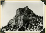 |
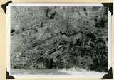
Casto Bluff head of Casto Canyon southwest edge of Sevier Plateau. Acidic lava underlain by Sevier(?) formation, Garfield County, UT, 1941 | P0013 Herbert E. Gregory Photograph Collection | P0013n11_148_2751 |
| 2 |
 |
Same as 2751, shows eroded top of Sevier Plateau | P0013 Herbert E. Gregory Photograph Collection | P0013n11_148_2752 |
| 3 |
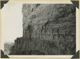 |
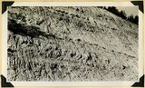
Castro Bluff, detail thin beds (upper) in Sevier(?) formation | P0013 Herbert E. Gregory Photograph Collection | P0013n11_149_2753 |
| 4 |
 |
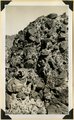
Casto Bluff, detail thick lava beds in Sevier(?) formation | P0013 Herbert E. Gregory Photograph Collection | P0013n11_149_2754 |
| 5 |
 |
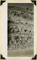
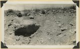
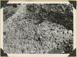
Castro Bluff, detail pumice conglomerate in Sevier formation | P0013 Herbert E. Gregory Photograph Collection | P0013n11_150_2755 |
| 6 |
 |
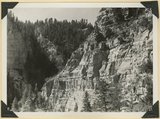
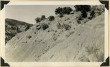
Castro Bluff, view looking westward from its base. Terrace developed in the Sevier(?) formation at the top of the Wasatch formation | P0013 Herbert E. Gregory Photograph Collection | P0013n11_150_2756 |
| 7 |
 |
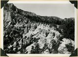
General view of eroded Pink Cliffs (Wasatch formation) near Cedar Breaks, Iron County, UT | P0013 Herbert E. Gregory Photograph Collection | P0013n11_151_2757 |
| 8 |
 |
View looking north from Pace Knoll (lava) near Deadman Gulch, showing tilted strata east of Hurricane Cliffs (extreme left). Virgin member of Moenkopi, Shinarump conglomerate and Chinle sandstones make hogbacks. Horse Ranch knoll, Navajo and Carmel in upper right, Washington County, UT, 1941 | P0013 Herbert E. Gregory Photograph Collection | P0013n11_151_2758 |
| 9 |
 |
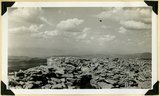
Panorama of Ashdown Canyon, 600-1800 feet deep, 20-150 feet wide out in Straight Cliffs sandstone. Iron County, UT, 1941 | P0013 Herbert E. Gregory Photograph Collection | P0013n11_152_2759 |
| 10 |
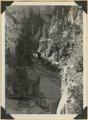 |
Panorama of Ashdown Canyon, 600-1800 feet deep, 20-150 feet wide out in Straight Cliffs sandstone. Iron County, UT, 1941 | P0013 Herbert E. Gregory Photograph Collection | P0013n11_152_2760 |
| 11 |
 |
Straight Cliffs sandstone (Cretaceous) Wall of Ashdown Canyon, Iron County, UT. 1941 | P0013 Herbert E. Gregory Photograph Collection | P0013n11_152_2761 |
| 12 |
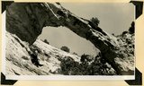 |
Natural bridge near top of wall of Ashdown Canyon, Iron County, UT, 1941 | P0013 Herbert E. Gregory Photograph Collection | P0013n11_153_2762 |
| 13 |
 |
Top of Brian Head (11,280 feet) showing fracture of rhyolite by frost. Iron County, UT. 1941 | P0013 Herbert E. Gregory Photograph Collection | P0013n11_154_2763 |
| 14 |
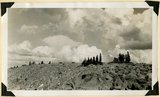 |
Top of ridge near head of Lauder Valley showing frost work and vegetation on Markagunt Plateau at altitudes between 10,000 and 11,000 feet. Iron County, UT, 1941 | P0013 Herbert E. Gregory Photograph Collection | P0013n11_154_2764 |
| 15 |
 |
Volcanic Conglomerate at the base of a succession of lavas on the cliff face of Brian Head. Iron County, UT. 1941 | P0013 Herbert E. Gregory Photograph Collection | P0013n11_155_2765 |
| 16 |
 |
Kaiparowits formation, head of Deep Creek, Iron County, UT. 1941 | P0013 Herbert E. Gregory Photograph Collection | P0013n11_155_2766 |
| 17 |
 |
Kaiparowits formation near southwest corner of Cedar Breaks National Monument. Iron County, UT. 1941 | P0013 Herbert E. Gregory Photograph Collection | P0013n11_156_2767 |
| 18 |
 |
Kaiparowits formation on Cedar City, Cedar Breaks road above Wood's Ranch. Iron County, UT. 1941 | P0013 Herbert E. Gregory Photograph Collection | P0013n11_156_2768 |
| 19 |
 |
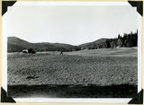
Glacial till, Castle Creek below Sidney Valley. Top of Markagunt Plateau. Iron County, UT. 1941 | P0013 Herbert E. Gregory Photograph Collection | P0013n11_157_2769 |
| 20 |
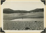 |
Sidney Valley. Ponds and mounds produced by glaciation. Iron County | P0013 Herbert E. Gregory Photograph Collection | P0013n11_157_2770 |
| 21 |
 |
Sidney Valley. Ponds and mounds produced by glaciation. Iron County | P0013 Herbert E. Gregory Photograph Collection | P0013n11_158_2771 |
| 22 |
 |
Talus of blocks from basalt sheet. Square Mountain. Iron County, UT. 1941 | P0013 Herbert E. Gregory Photograph Collection | P0013n11_158_2772 |
| 23 |
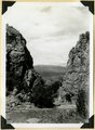 |
Mouth of Camp Creek. Resistant limestones of lowest Triassic make walls. Iron County, UT. 1941 | P0013 Herbert E. Gregory Photograph Collection | P0013n11_159_2773 |
| 24 |
 |
Contact of Triassic and Permian (beds in wall wrinkled at base). Cherty limestone lower left. Camp Creek. Iron County, UT. 1941 | P0013 Herbert E. Gregory Photograph Collection | P0013n11_159_2774 |
| 25 |
 |
Conglomerates, base of Timpoweep member of the Moenkopi Tarper Creek. Washington County, UT. 1941 | P0013 Herbert E. Gregory Photograph Collection | P0013n11_160_2775 |