|
|
Title | Collection Number And Name | Photo Number |
| 126 |
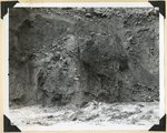 |
Virgin River in Zion National Park: erosion of land slide at flood stage | P0013 Herbert E. Gregory Photograph Collection | P0013n11_015_2549 |
| 127 |
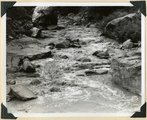 |
Stages of flood in branch of Parunuweap Canyon above Hidden Lake, result of local storm: beginning. Kane County, UT, 1937 | P0013 Herbert E. Gregory Photograph Collection | P0013n11_015_2550 |
| 128 |
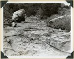 |
Stages of flood in branch of Parunuweap Canyon above Hidden Lake, result of local storm: rising water. Kane County, UT, 1937 | P0013 Herbert E. Gregory Photograph Collection | P0013n11_016_2551 |
| 129 |
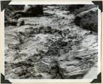 |
Stages of flood in branch of Parunuweap Canyon above Hidden Lake, result of local storm: high water. Kane County, UT, 1937 | P0013 Herbert E. Gregory Photograph Collection | P0013n11_016_2552 |
| 130 |
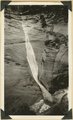 |
Ephemeral waterfall, disappears about half hour after rain. Pine Creek, Zion National Park, 1937 | P0013 Herbert E. Gregory Photograph Collection | P0013n11_022_2556 |
| 131 |
 |
Alluvial terraces, Parunuweap Valley between Orderville and Mt. Carmel. Lie unevenly on Tropic shale. Kane County, UT. 1937 | P0013 Herbert E. Gregory Photograph Collection | P0013n11_022_2557 |
| 132 |
 |
Coal in the Dakota or basal Tropic; Coal hill east side Meadow Brook. Kane County, UT | P0013 Herbert E. Gregory Photograph Collection | P0013n11_023_2558 |
| 133 |
 |
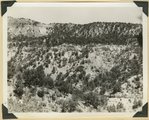
Wasatch formation, head of Dairy Canyon, tributary to the Parunuweap. Kane County, UT | P0013 Herbert E. Gregory Photograph Collection | P0013n11_023_2559 |
| 134 |
 |
Wasatch formation, head of Dairy Canyon, tributary to the Parunuweap. Kane County, UT | P0013 Herbert E. Gregory Photograph Collection | P0013n11_024_2560 |
| 135 |
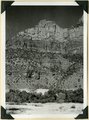 |
Upper Chinle, Wingate, Kayenta, and Navajo formations on face of Bridge Mountain. Springdale member, ledge near base. Zion National Park, UT | P0013 Herbert E. Gregory Photograph Collection | P0013n11_024_2561 |
| 136 |
 |
Travertine formed by plants, narrows of Virgin River. Zion National Park, UT | P0013 Herbert E. Gregory Photograph Collection | P0013n11_025_2562 |
| 137 |
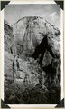 |
Cable Mountain, Navajo sandstone. Location of East Rim trail (center). Zion National Park | P0013 Herbert E. Gregory Photograph Collection | P0013n11_025_2563 |
| 138 |
 |
Navajo sandstone viewed from tunnel window across Pine Creek. The Sentinel in distance. Zion National Park | P0013 Herbert E. Gregory Photograph Collection | P0013n11_026_2564 |
| 139 |
 |
Jurassic formations near highway crossing of Meadow Brook. Carmel (lowest right); Entrada (middle slope); Curtis (gypsum, ledge); Winsor (upper slope); Dakota (black band); Tropic with coal at top (right). Kane County, UT | P0013 Herbert E. Gregory Photograph Collection | P0013n11_026_2565 |
| 140 |
 |
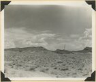
Heaton Point, south end of Elkheart Cliffs, Navajo sandstone and Carmel limestone, middle distance, Tropic shales and ancient alluvial terraces bordering Parunuweap River (foreground). Sevier fault lies near the base of the cliffs. Kane County, UT | P0013 Herbert E. Gregory Photograph Collection | P0013n11_027_2566 |
| 141 |
 |
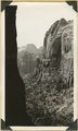
Cave Canyon walls of Navajo sandstone, above them shale and Temple Cap member forms second cliff, capped in turn with Carmel limestone. Zion National Park | P0013 Herbert E. Gregory Photograph Collection | P0013n11_027_2567 |
| 142 |
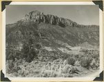 |
Smithsonian Butte from north base. Chinle, including Springdale member (middle ledge), Wingate? and Kayenta?, Navajo top. Washington County, UT | P0013 Herbert E. Gregory Photograph Collection | P0013n11_028_2568 |
| 143 |
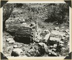 |
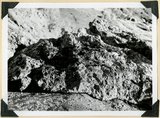
Petrified log near base of Chinle, north of Rockville. Zion National Park | P0013 Herbert E. Gregory Photograph Collection | P0013n11_028_2569 |
| 144 |
 |
Sevier fault in gully east of Mt. Carmel Junction. Tropic shale, rounded hills (left); Navajo sandstone in fracture zone (right). Kane County, UT | P0013 Herbert E. Gregory Photograph Collection | P0013n11_029_2570 |
| 145 |
 |
Harrisburg Dome near Leeds. Moenkopi and Shinarump strata. Washington County, UT | P0013 Herbert E. Gregory Photograph Collection | P0013n11_029_2571 |
| 146 |
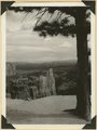 |
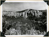
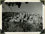
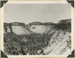
View southeast from Little Bryce Point across Paria amphitheater, pinnacles of Wasatch limestone; upturned edges Navajo sandstone (in distance). Bryce Canyon National Park | P0013 Herbert E. Gregory Photograph Collection | P0013n11_030_2572 |
| 147 |
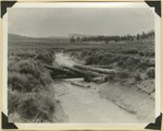 |
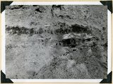
Valley on Paunsaugunt Plateau. Erosion control dam destroyed by torrential shower, 2.30 inches in 20 minutes. Bryce Canyon National Park | P0013 Herbert E. Gregory Photograph Collection | P0013n11_030_2573 |
| 148 |
 |
North Rim of canyon, Wasatch limestone. Iron Mountain in distance west. Cedar Breaks National Monument | P0013 Herbert E. Gregory Photograph Collection | P0013n11_031_2574 |
| 149 |
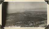 |
Panorama northwest of Brian Head, Markagunt Plateau. Glacial topography foreground; Wasatch formation (middle distance); Little Salt Lake in valley beyond Hurricane Cliffs. Iron County, UT | P0013 Herbert E. Gregory Photograph Collection | P0013n11_031_2575 |
| 150 |
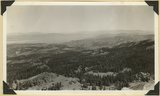 |
Panorama northwest of Brian Head, Markagunt Plateau. Glacial topography foreground; Wasatch formation (middle distance); Little Salt Lake in valley beyond Hurricane Cliffs. Iron County, UT | P0013 Herbert E. Gregory Photograph Collection | P0013n11_032_2576 |