|
|
Title | Collection Number And Name | Photo Number |
| 76 |
 |
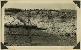
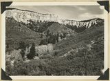
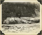
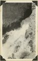
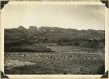
Pinnacles, Freemont River | P0013 Herbert E. Gregory Photograph Collection | P0013n10_185_2413 |
| 77 |
 |
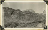
Unconformity west of Paria. Middle white, Shinarump; lower left, dark, Moenkopi; upper beds, Chinle. Kane County, Utah, 1937. | P0013 Herbert E. Gregory Photograph Collection | P0013n10_193_2432 |
| 78 |
 |
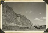
Triassic formations at Paria. Foreground, Moenkopi along road (dark) and Shinarump (light). Butte: Chinle (banded) capped with Wingate sandstone, Kane County, Utah, 1937. | P0013 Herbert E. Gregory Photograph Collection | P0013n10_194_2434 |
| 79 |
 |
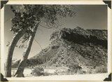
Elkheart Cliffs, blood-red buttes at base, on east side of the Sevier fault near Orderville,Kane County, Utah, 1937. | P0013 Herbert E. Gregory Photograph Collection | P0013n10_196_2436 |
| 80 |
 |
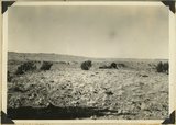
Mud flow, result of sudden shower in branch of Parunuweap River: break in highway. Three miles north of Glendale, Kane County, Utah, 1937. | P0013 Herbert E. Gregory Photograph Collection | P0013n10_196_2437 |
| 81 |
 |
Mud flow, result of sudden shower in branch of Parunuweap River: 1200 feet downstream. Three miles north of Glendale, Kane County, Utah, 1937. | P0013 Herbert E. Gregory Photograph Collection | P0013n10_196_2438 |
| 82 |
 |
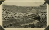
General view of tilted, from Kanab Road. Looking northwest across Sevier fault and Parunuweap River at Mt. Carmel, Kane County, Utah, 1937. | P0013 Herbert E. Gregory Photograph Collection | P0013n10_197_2441 |
| 83 |
 |
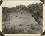
Tilted block broken from Sevier fault, Navajo capped by Carmel. Orderville, Kane County, Utah, 1937. | P0013 Herbert E. Gregory Photograph Collection | P0013n10_198_2442 |
| 84 |
 |
Pink Cliffs, Robinson Canyon, north of Alton. Cretaceous (Kaiparowits) contact with Wasatch (Tertiary) at the base of vertical cliffs. Kane County, Utah, 1937. | P0013 Herbert E. Gregory Photograph Collection | P0013n10_198_2444 |
| 85 |
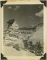 |
Tower of Navajo sandstone capped by iron concretion along highway near east Checking Station, Zion National Park, Utah, 1936. | P0013 Herbert E. Gregory Photograph Collection | P0013n10_199_2446 |
| 86 |
 |
Muhim Cliff Profile Indian Head Chinle strata. Springdale, Utah, 1937. | P0013 Herbert E. Gregory Photograph Collection | P0013n10_201_2449 |
| 87 |
 |
Wingate, Kanab Canyon. | P0013 Herbert E. Gregory Photograph Collection | P0013n10_202_2451 |
| 88 |
 |
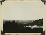
Virgin River at La Verkin Hot Springs. Shacks are shelters over intake pipes leading to the pool quarter of a mile down the river. Washington County, Utah, 1937. | P0013 Herbert E. Gregory Photograph Collection | P0013n10_202_2452 |
| 89 |
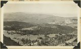 |
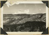
View southwest from Brian Head, showing head of Cedar Canyon, the northern Kolob Plateau, and Pine Valley Mountains (in distance). Iron County, Utah, 1937. | P0013 Herbert E. Gregory Photograph Collection | P0013n10_207_2462 |
| 90 |
 |
View north along the rim of Markagunt Plateau from Brian Head. Iron County, Utah, 1937. | P0013 Herbert E. Gregory Photograph Collection | P0013n10_208_2463 |
| 91 |
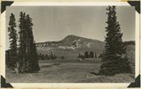 |
Brian Head, volcanic mass from the north rim of Cedar Breaks, Iron County, Utah, 1937. | P0013 Herbert E. Gregory Photograph Collection | P0013n10_208_2464 |
| 92 |
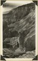 |
Rim of canyon at Cedar Breaks, Wasatch formation, Iron County, Utah, 1937. | P0013 Herbert E. Gregory Photograph Collection | P0013n10_209_2465 |
| 93 |
 |
Source of the Virgin River. Looking northwest along Cascade Falls Trail. Spring issues from Wasatch limestone cliffs of Markagunt Plateau. Garfield County, Utah, 1937. | P0013 Herbert E. Gregory Photograph Collection | P0013n10_211_2468 |
| 94 |
 |
Cascade Falls, source of Virgin River. Point of emergence from Wasatch limestone. Garfield County, Utah, 1937. | P0013 Herbert E. Gregory Photograph Collection | P0013n10_211_2469 |
| 95 |
 |
Head of the Fremont River Gorge in Capitol Reef at Fruita, Wayne County, Utah, 1937. | P0013 Herbert E. Gregory Photograph Collection | P0013n10_212_2470 |
| 96 |
 |
View northwest along Capitol Reef from top of shale slope near Mulford Ranch. Chinle and Wingate (right), river terrace (left). Wayne County, Utah, 1937. | P0013 Herbert E. Gregory Photograph Collection | P0013n10_212_2471 |
| 97 |
 |
Capitol Reef, looking SE down Sand Creek from point two miles west of Fruita. Moenkopi foreground; Shinarump-Navajo in cliffs; Henry Mountains in distance. Wayne County, Utah, 1937. | P0013 Herbert E. Gregory Photograph Collection | P0013n10_213_2472 |
| 98 |
 |
View down Fremont Gorge, in Capitol Reef. Left: Moenkopi, Chinle shales, talus slope and cliffs of Wingate. Right: Fruita, river terraces, cliffs of Wingate and high bumps of Navajo sandstone. Wayne County, Utah, 1937. | P0013 Herbert E. Gregory Photograph Collection | P0013n10_213_2473 |
| 99 |
 |
View looking NE along back-slope of Capitol Reef: Fremont River gorge and terraces, upper left; Capitol Wash in middle distance jointing Pleasant Creek at left; lava boulder terrace in foreground. Wayne County, Utah, 1937. | P0013 Herbert E. Gregory Photograph Collection | P0013n10_215_2476 |
| 100 |
 |
The back slopes of Capitol Reef, viewed from the summit of the Fruita-Cainesville road 1/2 mile west of Pleasant Creek. Navajo, Carmel, and red gypsiferous shale above the Carmel in middle foreground, crest of roof on horizon. Wayne County, Utah, 1937. | P0013 Herbert E. Gregory Photograph Collection | P0013n10_215_2477 |