Home
Browse
Ask Us
Chat
Harmful Language Statement
Log in
Photo Archives
Advanced Search
About
Over 70,000 photos covering a variety of topics from Marriott Library Special Collections
Year
1915
1916
1917
1918
1919
1920
1921
1922
1923
1924
1925
1926
1927
1928
1929
1930
1931
1932
1933
1934
1935
1936
1937
1938
TO
1915
1916
1917
1918
1919
1920
1921
1922
1923
1924
1925
1926
1927
1928
1929
1930
1931
1932
1933
1934
1935
1936
1937
1938
Type
Image
173
Format
image/jpeg
171
application/pdf
2
Collection
Photo Archives
173
Filters:
Collection Name:
"Herbert E. Gregory"
Date:
"1936"
101
-
125
of
173
<
1
2
3
4
5
6
7
>
Gallery view
Number of results to display per page
10
25
50
100
200
Sort by Relevance
Sort by Title A-Z
Sort by Title Z-A
Sort by Date Ascending
Sort by Date Descending
Sort by Last Modified Ascending
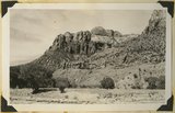
Sort by Last Modified Descending
Title
Date
Type
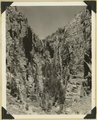
101
Old abandoned cotton mill at Washington, Utah.
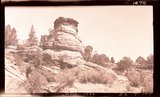
1930; 1931; 1932; 1933; 1934; 1935; 1936; 1937
Image
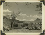
102
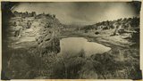
One of "Three Lakes," Kanab Canyon.
1930; 1931; 1932; 1933; 1934; 1935; 1936; 1937
Image
103
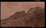
Panorama, Harris Mountain from south. All Navajo except for Carmel limestone on top highest mesas. Kane County, Utah, 1936.
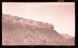
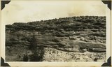
1936
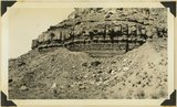
Image
104
Paria Village
1936
Image
105
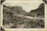
Parunuweap Canyon near east boundary of Zion Park, Utah, 1936.
1936
Image
106
Parunuweap Canyon, looking NW toward the Watchman. Springdale member center cliffs, Utah, 1936.
1936
Image
107
Perched pot holes, Pine Creek, near east end of tunnel, Zion National Park, Utah, 1936.
1936
Image
108
Pipe Springs
1936
Image
109
Rainbow Butte at Paria (Chinle strata). Moenkopi, left foreground, Kane County, Utah, 1937.
1936
Image
110
Refrigerator Canyon on the West Rim Trail. Zion National Park, Utah.
1936
Image
111
Remains of old town of Paria.
1930; 1931; 1932; 1933; 1934; 1935; 1936; 1937
Image
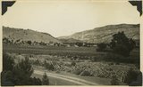
112
Rockville 1936
1936
Image
113
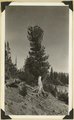
Roots of limber pine exposed by erosion, north rim of Cedar Breaks. Iron County, Utah, 1936.
1936
Image
114
Same as 191 (Looking north across Orderville, Sevier fault), taken nearer Orderville.
1930; 1931; 1932; 1933; 1934; 1935; 1936; 1937
Image
115
Sand dunes, head of Sand Canyon, 1936.
1936
Image
116
Sand Wash, 1936
1936
Image
117
Sandstone in Chinle marls, Springdale, 1936.
1936
Image
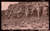
118
Sandstone ledges in upper part of Moenkopi. Shinarump conglomerate at extreme top. Rockville, Washington County, Utah, 1936.
1936
Image
119
Sandstone, head of Cave Wash, 1936
1936
Image
120
Shale formation where fossils are found. Near the Pine Creek bridge at the base of the switchboard on new Mt. Carmel road, Zion Canyon.
1930; 1931; 1932; 1933; 1934; 1935; 1936; 1937
Image
121
Shinarump conglomerate at mouth of Parunuweap Canyon, Washington County, Utah, 1936.
1936
Image
122
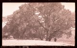
Short Creek, Ariz., Cottonwood trees in sand
1936
Image
123
Slice of Chinle on Sevier fault, Pipe Springs-Moccasin road, 1936.
1936
Image
124
Springdale
1936
Image
125
Springdale 1936
1936
Image
101
-
125
of
173
<
1
2
3
4
5
6
7
>