|
|
Title | Collection Number And Name | Photo Number |
| 126 |
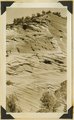 |
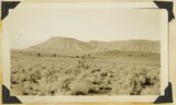
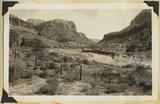
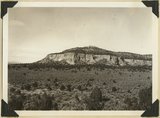
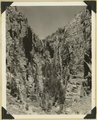
Wingate, Cottonwood Canyon, 1936. | P0013 Herbert E. Gregory Photograph Collection | P0013n10_188_2421 |
| 127 |
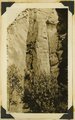 |
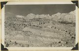
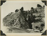
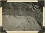
Jointing in Navajo on Zion-Carmel road, 1936. | P0013 Herbert E. Gregory Photograph Collection | P0013n10_188_2422 |
| 128 |
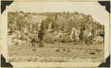 |
Carmel on North Fork, Virgin, 1936. | P0013 Herbert E. Gregory Photograph Collection | P0013n10_188_2423 |
| 129 |
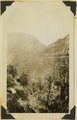 |
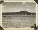
Congar Mt. fault, 1936. | P0013 Herbert E. Gregory Photograph Collection | P0013n10_189_2423 |
| 130 |
 |
Moenkopi and lava, Little Creek, 1936. | P0013 Herbert E. Gregory Photograph Collection | P0013n10_189_2424 |
| 131 |
 |
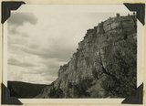
Elkheart Cliffs, 1936. | P0013 Herbert E. Gregory Photograph Collection | P0013n10_189_2425 |
| 132 |
 |
Cliffs, mouth of Parunuweap, Utah, 1936. | P0013 Herbert E. Gregory Photograph Collection | P0013n10_190_2426 |
| 133 |
 |
Parunuweap Canyon, looking NW toward the Watchman. Springdale member center cliffs, Utah, 1936. | P0013 Herbert E. Gregory Photograph Collection | P0013n10_190_2427 |
| 134 |
 |
Parunuweap Canyon near east boundary of Zion Park, Utah, 1936. | P0013 Herbert E. Gregory Photograph Collection | P0013n10_191_2428 |
| 135 |
 |
Chinle and above, near Springdale, Utah, 1936. | P0013 Herbert E. Gregory Photograph Collection | P0013n10_191_2429 |
| 136 |
 |
Erosion Cretaceous along Fruita-Cainsville road, Pleasant Creek 1936. | P0013 Herbert E. Gregory Photograph Collection | P0013n10_192_2430 |
| 137 |
 |
Looking down Fremont Gorge, Capitol Reef from west of Fruita 1936. | P0013 Herbert E. Gregory Photograph Collection | P0013n10_192_2431 |
| 138 |
 |
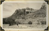
Rainbow Butte at Paria (Chinle strata). Moenkopi, left foreground, Kane County, Utah, 1937. | P0013 Herbert E. Gregory Photograph Collection | P0013n10_193_2433 |
| 139 |
 |
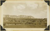
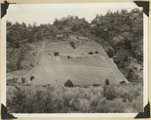
Block Mesas, east of Elephant Gap. Navajo sandstone capped by Carmel. Kane County, Utah, 1936. | P0013 Herbert E. Gregory Photograph Collection | P0013n10_195_2435 |
| 140 |
 |
Fault near Mt. Carmel Junction. Right (up throw side) Carmel limestone; left sands capped by gypsum. Three miles north of Glendale, | P0013 Herbert E. Gregory Photograph Collection | P0013n10_197_2439 |
| 141 |
 |
Straight Cliffs formation (Cretaceous). Orderville, Kane County, Utah. 1936 | P0013 Herbert E. Gregory Photograph Collection | P0013n10_197_2440 |
| 142 |
 |
Crater on Kanab Creek, at "the Corrals." Kane County, Utah, 1937. | P0013 Herbert E. Gregory Photograph Collection | P0013n10_198_2443 |
| 143 |
 |
Base of Dakota sandstone resting on white Jurassic. Meadow Brook, Kane County, Utah, 1936. | P0013 Herbert E. Gregory Photograph Collection | P0013n10_198_2445 |
| 144 |
 |
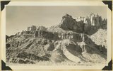
Crossbedded Navajo sandstone along Zion-Mt. Carmel road. Checker Board Mountain on the horizon eastward. Temple Cap member in upper right. Zion National Park, Utah, 1936. | P0013 Herbert E. Gregory Photograph Collection | P0013n10_199_2447 |
| 145 |
 |
Walters Wiggles, in Refrigerator Canyon, on trail to Angels Landing. Navajo strata. Zion National Park, Utah, 1936. | P0013 Herbert E. Gregory Photograph Collection | P0013n10_201_2450 |
| 146 |
 |
Wingate, Kanab Canyon. | P0013 Herbert E. Gregory Photograph Collection | P0013n10_202_2451 |
| 147 |
 |
Perched pot holes, Pine Creek, near east end of tunnel, Zion National Park, Utah, 1936. | P0013 Herbert E. Gregory Photograph Collection | P0013n10_202_2453 |
| 148 |
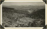 |
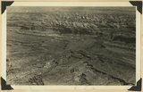
Grafton fault at west end of Smithsonian Butte, looking northward across Virgin River. Coalpits volcano in middle background, edge of Kolob plateau in distance. Washington County, Utah, 1936. | P0013 Herbert E. Gregory Photograph Collection | P0013n10_203_2454 |
| 149 |
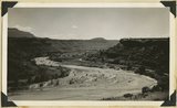 |
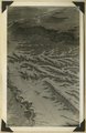
Meanders of the Virgin River, near Rockville. Moenkopi capped by Shinarump. Washington County, Utah, 1936. | P0013 Herbert E. Gregory Photograph Collection | P0013n10_203_2455 |
| 150 |
 |
Refrigerator Canyon on the West Rim Trail. Zion National Park, Utah. | P0013 Herbert E. Gregory Photograph Collection | P0013n10_204_2456 |