Home
Browse
Ask Us
Chat
Harmful Language Statement
Log in
Advanced Search
Year
1840
1841
1842
1843
1844
1845
1846
1847
1848
1849
1850
1851
1852
1853
1854
1855
1856
1857
1858
1859
1860
1861
1862
1863
1864
1865
1866
1867
1868
1869
1870
1871
1872
1873
1874
1875
1876
1877
1878
1879
1880
1881
1882
1883
1884
1885
1886
1887
1888
1889
1890
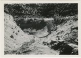
1891
1892
1893
1894
1895
1896
1897
1898
1899
1900
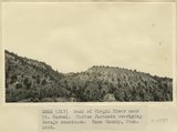
1901
1902
1903
1904
1905
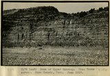
1906
1907
1908
1909
1910
1911
1912
1913
1914
1915
1916
1917
1918
1919
1920
1921
1922
1923
1924
1925
1926
1927
1928
1929
1930
1931
1932
1933
1934
1935
1936
1937
1938
1939
1940
1941
1942
1943
1944
1945
1946
1947
1948
1949
1950
1951
1952
1953
1954
1955
1956
1957
1958
1959
1960
1961
1962
1963
1964
1965
1966
1967
1968
1969
1970
1971
1972
1973
1974
1975
1976
1977
1978
1979
1980
1981
1982
1983
1984
1985
1986
1987
1988
1989
1990
1991
1992
1993
1994
1995
1996
1997
1998
1999
2000
2001
2002
2003
2004
2005
2006
2007
2008
TO
1840
1841
1842
1843
1844
1845
1846
1847
1848
1849
1850
1851
1852
1853
1854
1855
1856
1857
1858
1859
1860
1861
1862
1863
1864
1865
1866
1867
1868
1869
1870
1871
1872
1873
1874
1875
1876
1877
1878
1879
1880
1881
1882
1883
1884
1885
1886
1887
1888
1889
1890
1891
1892
1893
1894
1895
1896
1897
1898
1899
1900
1901
1902
1903
1904
1905
1906
1907
1908
1909
1910
1911
1912
1913
1914
1915
1916
1917
1918
1919
1920
1921
1922
1923
1924
1925
1926
1927
1928
1929
1930
1931
1932
1933
1934
1935
1936
1937
1938
1939
1940
1941
1942
1943
1944
1945
1946
1947
1948
1949
1950
1951
1952
1953
1954
1955
1956
1957
1958
1959
1960
1961
1962
1963
1964
1965
1966
1967
1968
1969
1970
1971
1972
1973
1974
1975
1976
1977
1978
1979
1980
1981
1982
1983
1984
1985
1986
1987
1988
1989
1990
1991
1992
1993
1994
1995
1996
1997
1998
1999
2000
2001
2002
2003
2004
2005
2006
2007
2008
Type
Image
1,299
Image/StillImage
100
Text
53
Sound
2
Format
image/jpeg
1,395
application/pdf
115
video/mp4
2
Collection
Beckwith Photograph Collection
9
Glen Canyon
1
Hiram B. Clawson Papers
1
Mormon Settlement in Arizona
2
Photo Archives
1,304
UAIDA Main Collection
2
Utah Humanities Research Foundation
2
Utah Quilt Heritage Records
44
Utah River Running Photo Archives
142
Western Soundscape
2
Western Waters NEH
2
Westminster University Photographs
2
More
Filters:
Spatial Coverage:
"Kane County (Utah)"
51
-
75
of
1,513
<
1
2
3
4
5
6
7
8
9
10
>
Gallery view
Number of results to display per page
10
25
50
100
200
Sort by Relevance
Sort by Title A-Z
Sort by Title Z-A
Sort by Date Ascending
Sort by Date Descending
Sort by Last Modified Ascending
Sort by Last Modified Descending
Title
Date
Type
Setname
51
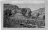
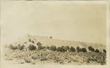
Alvin Porter barn and cliffs
Image
uum_map
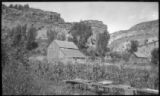
52
Alvin Porter barn and cliffs
Image
uum_map
53
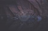
Annie's Canyon reflection
1965-09-21
Image
uum_map
54
Applique and Embroidery quilt, by Clorene R. Hoyt
1950; 1951; 1952; 1953; 1954; 1955; 1956; 1957; 1958; 1959
Text
uum_uqhr
55
Approaching Crossing of the Fathers
1957; 1958; 1959; 1960; 1961; 1962
uum_map_rr
56
Around the fire 'till after dark
1985-05-10; 1985-05-11; 1985-05-12
Image
uum_map
57
Arthur Lewis. Kanab Camp, UT. 1922
1922
Image
uum_map
58
Aspen forest, branch of Sevier River, east of Cedar Breaks, Kane County, Utah, 1930.
1930
Image
uum_map
59
At bottom of Hole in the Rock
1956-06
Image/StillImage
uum_map_rr
60
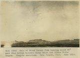
Axis of Water Pocket Fold looking south 30 degrees west from divide between Muley Twist and Silver Falls Canyon. Wingate sandstone. Kane County, UT. June 1918
1918
Image
uum_map
61
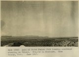
Axis of Water Pocket Fold looking southwest standing on Chinle. Wingate in distance. Kane County, UT. June 1918
1918
Image
uum_map
62
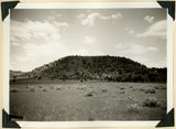
Bald Knoll Volcanic Cone near head of Johnson Creek. Kane County, UT. 1940
1940
Image
uum_map
63
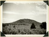
Bald Knoll Volcanic Cone near head of Johnson Creek. Kane County, UT. 1940
1940
Image
uum_map
64
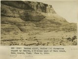
Banded cliff, McElmo (?) formation capped by Dakota, 2+ miles east of Warm Creek, Kane County, Utah. June 8, 1915.
1915
Image
uum_map
65
Banded shales with 3 beds of gypsum, 'Marine Jurassic,' Cottonwood Wash section. Kane County, UT, 1924
1924
Image
uum_map
66
Banded, friable sands, 'Marine Jurassic' between limestone bed and gypsum, 2 miles SW of Mt. Carmel
1924
Image
uum_map
67
Banded, friable sands, 'Marine Jurassic' between limestone bed and gypsum, 2 miles SW of Mt. Carmel
1924
Image
uum_map
68
Bank of Upper Wahweap. Mesa Verde strata. Kane County, UT. June 1918
1915
Image
uum_map
69
Bank of Virgin River near Mt. Carmel. Marine Jurassic overlying Navajo sandstone. Kane County, UT. 1922
1922
Image
uum_map
70
Bark Wash, Utah 1943
1943
Image
uum_map
71
Basalt cone near "corrals," upper Kanab Valley. Pinon and juniper. Kane County, Utah, 1932.
1934
Image
uum_map
72
Basalt flow from Bald Knob Volcano, upper Johnson Canyon. Kane County, Utah, 1938.
1938
Image
uum_map
73
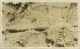
Basalt wall of East Fork of Virgin River above Glendale. Lava that filled the ancient canyon has been trenched. Kane County, Utah.
1930
Image
uum_map
74
Base of Dakota sandstone resting on white Jurassic. Meadow Brook, Kane County, Utah, 1936.
1936
Image
uum_map
75
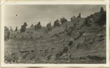
Base of Kaibab limestone and summit of Hermit Shale in Kaibab (Buckskin) Gulch. Coconino sandstone absent
1922
Image
uum_map
51
-
75
of
1,513
<
1
2
3
4
5
6
7
8
9
10
>