Home
Browse
Ask Us
Chat
Harmful Language Statement
Log in
Advanced Search
Year
1840
1841
1842
1843
1844
1845
1846
1847
1848
1849
1850
1851
1852
1853
1854
1855
1856
1857
1858
1859
1860
1861
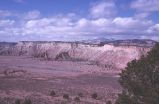
1862
1863
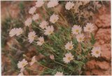
1864
1865
1866
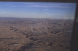
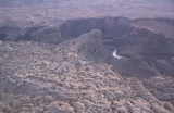
1867
1868
1869
1870
1871
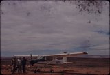
1872
1873
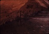
1874
1875
1876
1877
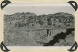
1878
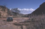
1879
1880
1881
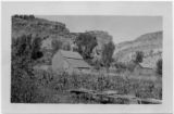
1882
1883
1884
1885
1886
1887
1888
1889
1890
1891
1892
1893
1894
1895
1896
1897
1898
1899
1900
1901
1902
1903
1904
1905
1906
1907
1908
1909
1910
1911
1912
1913
1914
1915
1916
1917
1918
1919
1920
1921
1922
1923
1924
1925
1926
1927
1928
1929
1930
1931
1932
1933
1934
1935
1936
1937
1938
1939
1940
1941
1942
1943
1944
1945
1946
1947
1948
1949
1950
1951
1952
1953
1954
1955
1956
1957
1958
1959
1960
1961
1962
1963
1964
1965
1966
1967
1968
1969
1970
1971
1972
1973
1974
1975
1976
1977
1978
1979
1980
1981
1982
1983
1984
1985
1986
1987
1988
1989
1990
1991
1992
1993
1994
1995
1996
1997
1998
1999
2000
2001
2002
2003
2004
2005
2006
2007
2008
TO
1840
1841
1842
1843
1844
1845
1846
1847
1848
1849
1850
1851
1852
1853
1854
1855
1856
1857
1858
1859
1860
1861
1862
1863
1864
1865
1866
1867
1868
1869
1870
1871
1872
1873
1874
1875
1876
1877
1878
1879
1880
1881
1882
1883
1884
1885
1886
1887
1888
1889
1890
1891
1892
1893
1894
1895
1896
1897
1898
1899
1900
1901
1902
1903
1904
1905
1906
1907
1908
1909
1910
1911
1912
1913
1914
1915
1916
1917
1918
1919
1920
1921
1922
1923
1924
1925
1926
1927
1928
1929
1930
1931
1932
1933
1934
1935
1936
1937
1938
1939
1940
1941
1942
1943
1944
1945
1946
1947
1948
1949
1950
1951
1952
1953
1954
1955
1956
1957
1958
1959
1960
1961
1962
1963
1964
1965
1966
1967
1968
1969
1970
1971
1972
1973
1974
1975
1976
1977
1978
1979
1980
1981
1982
1983
1984
1985
1986
1987
1988
1989
1990
1991
1992
1993
1994
1995
1996
1997
1998
1999
2000
2001
2002
2003
2004
2005
2006
2007
2008
Type
Image
1,299
Image/StillImage
100
Text
53
Sound
2
Format
image/jpeg
1,395
application/pdf
115
video/mp4
2
Collection
Beckwith Photograph Collection
9
Glen Canyon
1
Hiram B. Clawson Papers
1
Mormon Settlement in Arizona
2
Photo Archives
1,304
UAIDA Main Collection
2
Utah Humanities Research Foundation
2
Utah Quilt Heritage Records
44
Utah River Running Photo Archives
142
Western Soundscape
2
Western Waters NEH
2
Westminster University Photographs
2
More
Filters:
Spatial Coverage:
"Kane County (Utah)"
26
-
50
of
1,513
<
1
2
3
4
5
6
7
8
9
10
>
Gallery view
Number of results to display per page
10
25
50
100
200
Sort by Relevance
Sort by Title A-Z
Sort by Title Z-A
Sort by Date Ascending
Sort by Date Descending
Sort by Last Modified Ascending
Sort by Last Modified Descending
Title
Date
Type
Setname
26
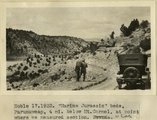
'Marine Jurassic' beds, Paunuweap, 4 miles below Mt. Carmel., at point where we measured section. UT
1922
Image
uum_map
27
'The Granary': one of many natural cavities in Wingate sandstone utilized for storage, Johnson Canyon, Kane County, UT, 1939
1939
Image
uum_map
28
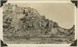
'White Throne' remnant of Navajo sandstone in branch of Paria River. Kane County, UT, 1940
1940
Image
uum_map
29
1, Navajo sandstone (at base); 2, shales; 3, sandstone bed that forms "entablatures" on "Temples" of Zion National Park; 4, Carmel and above. Zion-Mount Carmel highway, Kane County, Utah, 1931.
1931
Image
uum_map
30
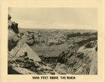
2000 feet above the River- Cottonwood Canyon in the background. "How the pioneers must have felt when they first stood at the top of Hole-in-the-Rock and saw this view!"
1939
Image
uum_map_rr
31
[Upper wall of Big Meadow Canyon (on Zion-Mt. Carmel road). Morrison strata, unconsolidated Dakota ? (black band), and coal-bearing Cretaceous. Kane County, Utah, 1930]
1930
Image
uum_map
32
A few wild flowers
1985-05-10; 1985-05-11; 1985-05-12
Image
uum_map
33
A high grassy bar between views of Roost Arch
1963-04-23
Image
uum_map
34
Across to snow covered peaks and Kodachrome Flats along Cottonwood Wash Road
1950; 1951; 1952; 1953; 1954; 1955; 1956; 1957; 1958; 1959; 1960; 1961; 1962; 1963; 1964; 1965; 1966; 1967; 1968; 1969; 1970
Image
uum_map
35
Aerial view of Escalante River canyon, from Glen Canyon
1962-09
Image
uum_map
36
Aerial view of Hole in the Rock
1964-05
Image
uum_map
37
Aerial views of the Escalante River canyons, post-Lake Powell - looking toward Page, AZ
1963; 1964; 1965; 1966; 1967; 1968
Image
uum_map_rr
38
Aerial views of the Escalante River canyons, post-Lake Powell.
1963; 1964; 1965; 1966; 1967; 1968
Image
uum_map_rr
39
Agriculture under irrigation in the basin of Virgin River
1903
Text
wwdl_neh
40
Airplane at Hole in the Rock airstrip
1964-05
Image
uum_map
41
Airplane near Davis Gulch
1964-05
Image
uum_map
42
Alcove, Escalante canyon country
1964-05
Image
uum_map
43
Alluvial terraces made since 1900, Johnson Creek, Kane County, UT, 1939
1939
Image
uum_map
44
Alluvial terraces on Kanab Creek near mouth of Tiny Canyon, Kane County, UT. 1939. Excavated since 1882
1939
Image
uum_map
45
Alluvial terraces, Parunuweap Valley between Orderville and Mt. Carmel. Lie unevenly on Tropic shale. Kane County, UT. 1937
1937
Image
uum_map
46
Alluvium valley fill trenched by stream since 1900. Lower Flood Canyon. Kane County, UT. 1943
1943
Image
uum_map
47
Along Cottonwood Wash Road, southern Utah
1973-05
Image
uum_map
48
Along Wahweap Stream. Cross bedding sandstone. Kane County, UT. June 1918
1918
Image
uum_map
49
Alton-Johnson Road
1936
Image
uum_map
50
Alvin Porter barn and cliffs
Image
uum_map
26
-
50
of
1,513
<
1
2
3
4
5
6
7
8
9
10
>