| Title | Date | Type | Setname | ||
|---|---|---|---|---|---|
| 326 |
 |
Mount Olympus | 1910; 1911; 1912; 1913; 1914; 1915; 1916; 1917; 1918; 1919; 1920; 1921; 1922; 1923; 1924; 1925; 1926; 1927; 1928; 1929; 1930; 1931; 1932; 1933; 1934; 1935; 1936; 1937; 1938; 1939; 1940 | Image/StillImage | dha_gmo |
| 327 |
 |
Mount Timpanogos, Utah | 1930; 1931; 1932; 1933; 1934; 1935; 1936; 1937; 1938; 1939; 1940; 1941; 1942; 1943; 1944; 1945; 1946; 1947; 1948; 1949; 1950 | Image/StillImage | uaida_main |
| 328 |
 |
Mountain Butte | 1930; 1931; 1932; 1933; 1934; 1935; 1936; 1937; 1938; 1939; 1940 | Image/StillImage | dha_rkc |
| 329 |
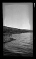 |
Mountain Lake | 1930; 1931; 1932; 1933; 1934; 1935; 1936; 1937; 1938; 1939; 1940 | Image/StillImage | dha_rkc |
| 330 |
 |
Mountain Lake | 1930; 1931; 1932; 1933; 1934; 1935; 1936; 1937; 1938; 1939; 1940 | Image/StillImage | dha_rkc |
| 331 |
 |
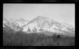
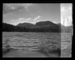
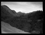
Mountain landscape | 1910; 1911; 1912; 1913; 1914; 1915; 1916; 1917; 1918; 1919; 1920; 1921; 1922; 1923; 1924; 1925; 1926; 1927; 1928; 1929; 1930; 1931; 1932; 1933; 1934; 1935; 1936; 1937; 1938; 1939; 1940 | Image/StillImage | dha_gmo |
| 332 |
 |
Mountain landscape | 1910; 1911; 1912; 1913; 1914; 1915; 1916; 1917; 1918; 1919; 1920; 1921; 1922; 1923; 1924; 1925; 1926; 1927; 1928; 1929; 1930; 1931; 1932; 1933; 1934; 1935; 1936; 1937; 1938; 1939; 1940 | Image/StillImage | dha_gmo |
| 333 |
 |
Mountain peak with a dotted line showing the path of descent | 1971-06 | Image | uum_map_usa |
| 334 |
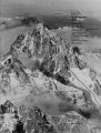 |
Mountain peak with a dotted line showing the path of descent | 1971-06 | Image | uum_map_usa |
| 335 |
 |
Mountain peak with a dotted line showing the path of descent | 1971-06 | Image | uum_map_usa |
| 336 |
 |
Mountain peak with a dotted line showing the path of descent | 1971-06 | Image | uum_map_usa |
| 337 |
 |
Mountain peak with a dotted line showing the path of descent | 1971-06 | Image | uum_map_usa |
| 338 |
 |
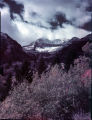
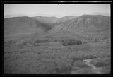
Mountain Scene | 1930; 1931; 1932; 1933; 1934; 1935; 1936; 1937; 1938; 1939; 1940 | Image/StillImage | dha_rkc |
| 339 |
 |
Mountain scenic | 1900; 1901; 1902; 1903; 1904; 1905; 1906; 1907; 1908; 1909; 1910; 1911; 1912; 1913; 1914; 1915; 1916; 1917; 1918; 1919; 1920; 1921; 1922; 1923; 1924; 1925 | Image/StillImage | dha_gmo |
| 340 |
 |
Mountain Stream | 1930; 1931; 1932; 1933; 1934; 1935; 1936; 1937; 1938; 1939; 1940 | Image/StillImage | dha_rkc |
| 341 |
 |
Mountain View | 1930; 1931; 1932; 1933; 1934; 1935; 1936; 1937; 1938; 1939; 1940 | Image/StillImage | dha_rkc |
| 342 |
 |
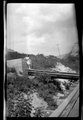
Mountains, farm | 1910; 1911; 1912; 1913; 1914; 1915; 1916; 1917; 1918; 1919; 1920; 1921; 1922; 1923; 1924; 1925; 1926; 1927; 1928; 1929; 1930; 1931; 1932; 1933; 1934; 1935; 1936; 1937; 1938; 1939; 1940 | Image/StillImage | dha_gmo |
| 343 |
 |
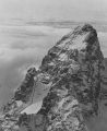
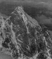
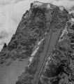
Mt. Nebo from the Northwest. One can see the three main summits: South (11,877), Middle (11,824) and North (11,928) plus the North Shoulder. To the left of the latter is Wolf Pass, the key to the North Peak. The South Peak climb (1961) was done under snow conditions similar to those in the picture. The 1963 North Peak winter ascent was done under much lighter conditions. | 1960; 1961; 1962; 1963 | Image | uum_map |
| 344 |
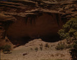 |
Mummy Cave | Image/StillImage | uaida_main | |
| 345 |
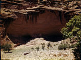 |
Mummy Cave [1] | 1930; 1931; 1932; 1933; 1934; 1935; 1936; 1937; 1938; 1939; 1940; 1941; 1942; 1943; 1944; 1945; 1946; 1947; 1948; 1949; 1950 | Image/StillImage | uaida_main |
| 346 |
 |
Mummy Cave [2] | 1930; 1931; 1932; 1933; 1934; 1935; 1936; 1937; 1938; 1939; 1940; 1941; 1942; 1943; 1944; 1945; 1946; 1947; 1948; 1949; 1950 | Image/StillImage | uaida_main |
| 347 |
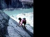 |
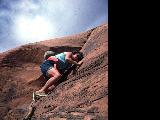
Natalie Gignoux climbing a rock with a view of sandstone rock formations and Glen Canyon behind her | 1962 | uum_map_rr | |
| 348 |
 |
Natalie Gignoux climbing a sandstone cliff. | 1962 | uum_map_rr | |
| 349 |
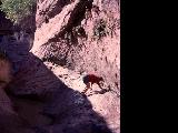 |
Natalie Gignoux scrambling through a narrow side canyon. | 1962 | uum_map_rr | |
| 350 |
 |
National Copper Bank, Copy of Painting by J. Fery | 1920-09-25 | Image/StillImage | dha_scnpp |