Diaries, maps and trails of Mormon pioneers and their westward migration in the 1850s. Diaries include Joseph C. Kingsbury, George A. Thomas, John B. Fairbanks, Joseph A. Young, and Lucia Lamb Everett.
TO
1 - 25 of 7
| Title | Date | Type | ||
|---|---|---|---|---|
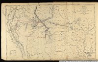
| 1 |
 |
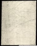
Map no. 2, from the Great Salt Lake to the Humboldt Mountains. | 1855 | Image/StillImage |
| 2 |
 |
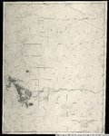
Map no. 2, from the mouth of Trap Creek to the Santa Fe crossing. | 1855 | Image/StillImage |
| 3 |
 |
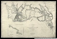
Map no. 3 from the Santa Fe crossing to the Coo-Che-to-pa Pass. | 1855 | Image/StillImage |
| 4 |
 |
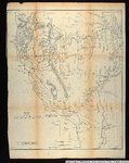
Map no. 3, Rocky Mountains to Puget Sound. | 1855 | Image/StillImage |
| 5 |
 |
Map showing the different routes travelled over by the detachments of the Overland Command in the spring of 1855 from Salt Lake City, Utah, to the Bay of San Francisco. | 1855 | Image/StillImage |
| 6 |
 |
Territories of New Mexico and Utah. | 1855 | Image/StillImage |
| 7 |
 |
Utah and the Overland Routes to it from the Missouri River | 1855 | Image/StillImage |
1 - 25 of 7