Home
Browse
Ask Us
Chat
Harmful Language Statement
Log in
Advanced Search
Year
1840
1841
1842
1843
1844
1845
1846
1847
1848
1849
1850
1851
1852
1853
1854
1855
1856
1857
1858
1859
1860
1861
1862
1863
1864
1865
1866
1867
1868
1869
1870
1871
1872
1873
1874
1875
1876
1877
1878
1879
1880
1881
1882
1883
1884
1885
1886
1887
1888
1889
1890
1891
1892
1893
1894
1895
1896
1897
1898
1899
1900
1901
1902
1903
1904
1905
1906
1907
1908
1909
1910
1911
1912
1913
1914
1915
1916
1917
1918
1919
1920
1921
1922
1923
1924
1925
1926
1927
1928
1929
1930
1931
1932
1933
1934
1935
1936
1937
1938
1939
1940
1941
1942
1943
1944
1945
1946
1947
1948
1949
1950
1951
1952
1953
1954
1955
1956
1957
1958
1959
1960
1961
1962
1963
1964
1965
1966
1967
1968
1969
1970
1971
1972
1973
1974
1975
1976
1977
1978
1979
1980
1981
1982
1983
1984
1985
1986
1987
1988
1989
1990
1991
1992
1993
1994
1995
1996
1997
1998
1999
2000
2001
2002
2003
2004
2005
2006
2007
2008
TO
1840
1841
1842
1843
1844
1845
1846
1847
1848
1849
1850
1851
1852
1853
1854
1855
1856
1857
1858
1859
1860
1861
1862
1863
1864
1865
1866
1867
1868
1869
1870
1871
1872
1873
1874
1875
1876
1877
1878
1879
1880
1881
1882
1883
1884
1885
1886
1887
1888
1889
1890
1891
1892
1893
1894
1895
1896
1897
1898
1899
1900
1901
1902
1903
1904
1905
1906
1907
1908
1909
1910
1911
1912
1913
1914
1915
1916
1917
1918
1919
1920
1921
1922
1923
1924
1925
1926
1927
1928
1929
1930
1931
1932
1933
1934
1935
1936
1937
1938
1939
1940
1941
1942
1943
1944
1945
1946
1947
1948
1949
1950
1951
1952
1953
1954
1955
1956
1957
1958
1959
1960
1961
1962
1963
1964
1965
1966
1967
1968
1969
1970
1971
1972
1973
1974
1975
1976
1977
1978
1979
1980
1981
1982
1983
1984
1985
1986
1987
1988
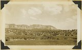
1989
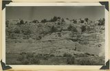
1990
1991
1992
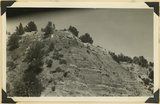
1993
1994
1995
1996
1997
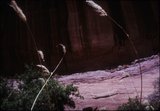
1998
1999
2000
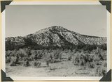
2001
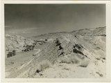
2002
2003
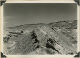
2004
2005
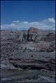
2006
2007
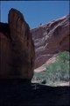
2008
Type
Image
1,280
Image/StillImage
116
Text
53
Sound
2
Format
image/jpeg
1,392
application/pdf
115
video/mp4
2
Collection
Beckwith Photograph Collection
9
Glen Canyon
1
Hiram B. Clawson Papers
1
Mormon Settlement in Arizona
2
Photo Archives
1,304
UAIDA Main Collection
2
Utah Humanities Research Foundation
2
Utah Quilt Heritage Records
44
Utah River Running Photo Archives
139
Western Soundscape
2
Western Waters NEH
2
Westminster University Photographs
2
More
Filters:
Spatial Coverage:
"Kane County (Utah)"
326
-
350
of
1,510
<
9
10
11
12
13
14
15
16
17
18
>
Gallery view
Number of results to display per page
10
25
50
100
200
Sort by Relevance
Sort by Title A-Z
Sort by Title Z-A
Sort by Date Ascending
Sort by Date Descending
Sort by Last Modified Ascending
Sort by Last Modified Descending
Title
Date
Type
Setname
326
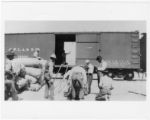
Eight men and a boxcar. Men freighting wool from Orderville to the rail head in Marysvale, Utah
Image
uum_map
327
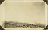
Elephant Gap in Harris Mountain from Arizona-Utah line north of Cane beds. Navajo sandstone, foreground, and cliffs, Carmel caps, Kane County, Utah, 1936.
1936
Image
uum_map
328
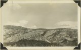
Elkheart Cliffs along highway about mile north of Orderville. Background and right foreground Navajo sandstone capped by Carmel formation. Left foreground slice of cliff dropped down along Sevier fault. Kane County, Utah, 1932.
1934
Image
uum_map
329
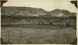
Elkheart Cliffs east of Mt. Carmel.
1930; 1931; 1932; 1933; 1934; 1935; 1936; 1937
Image
uum_map
330
Elkheart Cliffs, 1936.
1936
Image
uum_map
331
Elkheart Cliffs, blood-red buttes at base, on east side of the Sevier fault near Orderville,Kane County, Utah, 1937.
1937
Image
uum_map
332
Elma speaking at Kanab State Convention, May, 1975
1975-05
uum_map
333
Entrada sandstone (bottom) in contact with shales and gypsum of Curtis formation, Paria Valley 4 miles south of Cannonville, Kane County, UT. 1939
1939
Image
uum_map
334
Entrada sandstone overlain by the heavy gypsum bed of the Curtis formation. Carmel limestone at left brought to level of Entrada by a fault, on Highway 15 near junction with Highway 89. Kane County, UT, 1938
1938
Image
uum_map
335
Entrada, Curtis, and Winsor formation overlain by Dakota (extreme top), Alton-Skutumpah road, Kane County, UT, 1939
1939
Image
uum_map
336
Entrance to the Cathedral in the Desert
1965-09-21
Image
uum_map
337
Entrance to Twilight Canyon
1963-04-26
Image
uum_map
338
Eroded alluvial fill 60 feet thick in Kanab Creek. In 1884 stream ran at top of terrace, Kane Co., Utah, 1939
1939
Image
uum_map
339
Eroded edge of basalt flow from Bald Knoll. White Cliffs, Navajo sandstone (upper right); middle Johnson Canyon. Kane County, UT, 1940
1940
Image
uum_map
340
Eroded flank of the East Kaibab monocline at the junction of Paria River and Cottonwood Creek (left center). The sequence is Navajo (left), upper Jurassic (largely eroded), Dakota, Tropic, and Straight Cliffs. Kane County, UT, 1944
1944
Image
uum_map
341
Eroded flank of the East Kaibab monocline at the junction of Paria River and Cottonwood Creek (left center). The sequence is Navajo (left), upper Jurassic (largely eroded), Dakota, Tropic, and Straight Cliffs. Kane County, UT, 1944
1944
Image
uum_map
342
Erosion remnants in upper (white) part of Wasatch formation: limestone and conglomerate. Castle Wash an upper tributary to Sevier River. Kane County, UT, 1940
1940
Image
uum_map
343
Erosion surface on lower Chinle beds at base of Vermillion Cliffs, traversed by Kanab Creek (left center), Kane County, UT. 1939
1939
Image
uum_map
344
Escalante Canyon country scene: base of a cliff
1964-05
Image
uum_map
345
Escalante Canyon country scene: Ken Sleight expedition, May 1964
1964-05
Image
uum_map
346
Escalante canyon country scene: River under sandstone walls
1964-05
Image
uum_map
347
Escalante Canyon country scene: sandstone landscape
1964-05
Image
uum_map
348
Escalante Canyon country scene: sandstone landscape
1964-05
Image
uum_map
349
Escalante canyon country scene: Sandstone walls and pillars
1964-05
Image
uum_map
350
Escalante canyon country scene: Sandstone walls and pillars
1964-05
Image
uum_map
326
-
350
of
1,510
<
9
10
11
12
13
14
15
16
17
18
>