Home
Browse
Ask Us
Chat
Harmful Language Statement
Log in
Advanced Search
Year
1840
1841
1842
1843
1844
1845
1846
1847
1848
1849
1850
1851
1852
1853
1854
1855
1856
1857
1858
1859
1860
1861
1862
1863
1864
1865
1866
1867
1868
1869
1870
1871
1872
1873
1874
1875
1876
1877
1878
1879
1880
1881
1882
1883
1884
1885
1886
1887
1888
1889
1890
1891
1892
1893
1894
1895
1896
1897
1898
1899
1900
1901
1902
1903
1904
1905
1906
1907
1908
1909
1910
1911
1912
1913
1914
1915
1916
1917
1918
1919
1920
1921
1922
1923
1924
1925
1926
1927
1928
1929
1930
1931
1932
1933
1934
1935
1936
1937
1938
1939
1940
1941
1942
1943
1944
1945
1946
1947
1948
1949
1950
1951
1952
1953
1954
1955
1956
1957
1958
1959
1960
1961
1962
1963
1964
1965
1966
1967
1968
1969
1970
1971
1972
1973
1974
1975
1976
1977
1978
1979
1980
1981
1982
1983
1984
1985
1986
1987
1988
1989
1990
1991
1992
1993
1994
1995
1996
1997
1998
1999
2000
2001
2002
2003
2004
2005
2006
2007
2008
TO
1840
1841
1842
1843
1844
1845
1846
1847
1848
1849
1850
1851
1852
1853
1854
1855
1856
1857
1858
1859
1860
1861
1862
1863
1864
1865
1866
1867
1868
1869
1870
1871
1872
1873
1874
1875
1876
1877
1878
1879
1880
1881
1882
1883
1884
1885
1886
1887
1888
1889
1890
1891
1892
1893
1894
1895
1896
1897
1898
1899
1900
1901
1902
1903
1904
1905
1906
1907
1908
1909
1910
1911
1912
1913
1914
1915
1916
1917
1918
1919
1920
1921
1922
1923
1924
1925
1926
1927
1928
1929
1930
1931
1932
1933
1934
1935
1936
1937
1938
1939
1940
1941
1942
1943
1944
1945
1946
1947
1948
1949
1950
1951
1952
1953
1954
1955
1956
1957
1958
1959
1960
1961
1962
1963
1964
1965
1966
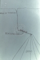
1967
1968
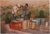
1969
1970
1971
1972
1973
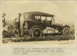
1974
1975
1976
1977
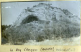
1978
1979
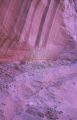
1980
1981
1982
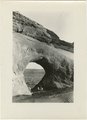
1983
1984
1985
1986
1987
1988
1989
1990
1991
1992
1993
1994
1995
1996
1997
1998
1999
2000
2001
2002
2003
2004
2005
2006
2007
2008
Type
Image
1,280
Image/StillImage
116
Text
53
Sound
2
Format
image/jpeg
1,392
application/pdf
115
video/mp4
2
Collection
Beckwith Photograph Collection
9
Glen Canyon
1
Hiram B. Clawson Papers
1
Mormon Settlement in Arizona
2
Photo Archives
1,304
UAIDA Main Collection
2
Utah Humanities Research Foundation
2
Utah Quilt Heritage Records
44
Utah River Running Photo Archives
139
Western Soundscape
2
Western Waters NEH
2
Westminster University Photographs
2
More
Filters:
Spatial Coverage:
"Kane County (Utah)"
301
-
325
of
1,510
<
8
9
10
11
12
13
14
15
16
17
>
Gallery view
Number of results to display per page
10
25
50
100
200
Sort by Relevance
Sort by Title A-Z
Sort by Title Z-A
Sort by Date Ascending
Sort by Date Descending
Sort by Last Modified Ascending
Sort by Last Modified Descending
Title
Date
Type
Setname
301
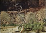
Dead tree, Escalante Canyon
1964-05
Image
uum_map
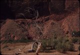
302
Dead tree, Escalante Canyon
1964-05
Image
uum_map
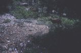
303
Deer in forest near Natural Bridge, Bryce Canyon
1959-06-25
Image
uum_map
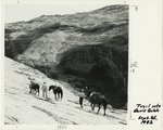
304
Descending the only horse trail into Davis Gulch, September 1982
1982-09
Image
uum_map
305
Diagram showing Hole-in-the-Rock trail and Ben's Dugway
1960; 1961; 1962; 1963; 1964; 1965; 1966; 1967; 1968; 1969; 1970; 1971; 1972; 1973; 1974; 1975; 1976; 1977; 1978; 1979; 1980
Image
uum_map
306
Dick Barney on top of small falls on Clear Creek
1963-04-23
Image
uum_map
307
Dinner at campsite
1985-05-10; 1985-05-11; 1985-05-12
Image
uum_map
308
Distant view of Moqui Ruin and its surroundings
1963-04-23
Image
uum_map
309
Diversion dam above Orderville [and] Diversion dam above Escalante in Potato Valley
1930; 1931; 1932
Image/StillImage
uum_map
310
Don Hayes down into the gulch after 1 1/2 hr hike
1985-05-10; 1985-05-11; 1985-05-12
Image
uum_map
311
Double Blocks quilt by Unknown quilter
1840; 1841; 1842; 1843; 1844; 1845; 1846; 1847; 1848; 1849; 1850
Text
uum_uqhr
312
Dr. Noble's Franklin car stuck in mud on Hurricane-Kanab road, Kane County, UT. 1922
1922
Image
uum_map
313
Dresden Plate quilt, by Albetina Miller Temple
1930; 1931; 1932; 1933; 1934; 1935; 1936; 1937; 1938; 1939
Text
uum_uqhr
314
Dresden Plate quilt, by Wilma Meeks
1950; 1951; 1952; 1953; 1954; 1955; 1956; 1957; 1958; 1959
Text
uum_uqhr
315
Drinking from a stream
1964-05
Image
uum_map
316
Dry Canyon at the Esplin ranch
Image
uum_map
317
Dry Canyon Mouth - Esplin ranch
Image
uum_map
318
Dry falls in Annie's Canyon
1965-09-21
Image
uum_map
319
Duck Lake (Navajo Lake) formed by lava flow (foreground) that crossed a branch of Sevier River. On road east of Cedar Breaks, Kane County, Utah, 1930.
1930
Image
uum_map
320
E. Kanab
1936
Image
uum_map
321
Eagle Gate, Natural Arch, Johnson's Ranch, Southern Utah
1863; 1864; 1865; 1866; 1867; 1868; 1869; 1870; 1871; 1872; 1873; 1874; 1875
Image/StillImage
uum_map
322
East side of Lone Rock on Wah Weap Creek
1943; 1944; 1945
Image
uum_map
323
East side of lower Wahweap Valley. White rocks below Dakota. Kane County, UT. 1922
1922
Image
uum_map
324
East wall Meadow Brook Canyon, near highway crossing. Carmel limestone (bottom), Entrada, Curtis, Winsor, Dakota (black band, upper left), base of Tropic shales. Kane County, UT
1937; 1938
Image
uum_map
325
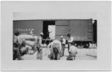
Eight men and a boxcar. Men freighting wool from Orderville to the rail head in Marysvale, Utah
Image
uum_map
301
-
325
of
1,510
<
8
9
10
11
12
13
14
15
16
17
>