Home
Browse
Ask Us
Chat
Harmful Language Statement
Log in
Advanced Search
Year
1849
1850
1851
1852
1853
1854
1855
1856
1857
1858
1859
1860
1861
1862
1863
1864
1865
1866
1867
1868
1869
1870
1871
1872
1873
1874
1875
1876
1877
1878
1879
1880
1881
1882
1883
1884
1885
1886
1887
1888
1889
1890
1891
1892
1893
1894
1895
1896
1897
1898
1899
1900
1901
1902
1903
1904
1905
1906
1907
1908
1909
1910
1911
1912
1913
1914
1915
1916
1917
1918
1919
1920
1921
1922
1923
1924
1925
1926
1927
1928
1929
1930
1931
1932
1933
1934
1935
1936
1937
1938
1939
1940
1941
1942
1943
1944
1945
1946
1947
1948
1949
1950
1951
1952
1953
1954
1955
1956
1957
1958
1959
1960
1961
1962
1963
1964
1965
1966
1967
1968
1969
1970
1971
1972
1973
1974
1975
1976
1977
1978
1979
1980
1981
1982
1983
1984
1985
1986
1987
1988
1989
1990
1991
1992
1993
1994
1995
1996
1997
1998
1999
2000
2001
2002
2003
2004
2005
2006
2007
2008
2009
2010
2011
2012
2013
2014
2015
2016
2017
2018
2019
2020
2021
2022
2023
TO
1849
1850
1851
1852
1853
1854
1855
1856
1857
1858
1859
1860
1861
1862
1863
1864
1865
1866
1867
1868
1869
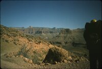
1870
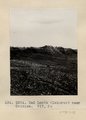
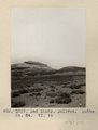
1871
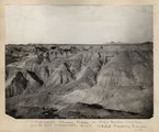
1872
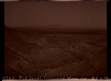
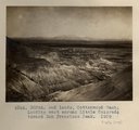
1873
1874
1875
1876
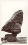
1877
1878
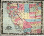
1879
1880
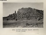
1881
1882
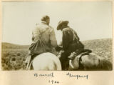
1883
1884
1885
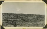
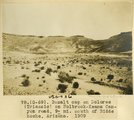
1886
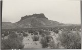
1887
1888
1889
1890
1891
1892
1893
1894
1895
1896
1897
1898
1899
1900
1901
1902
1903
1904
1905
1906
1907
1908
1909
1910
1911
1912
1913
1914
1915
1916
1917
1918
1919
1920
1921
1922
1923
1924
1925
1926
1927
1928
1929
1930
1931
1932
1933
1934
1935
1936
1937
1938
1939
1940
1941
1942
1943
1944
1945
1946
1947
1948
1949
1950
1951
1952
1953
1954
1955
1956
1957
1958
1959
1960
1961
1962
1963
1964
1965
1966
1967
1968
1969
1970
1971
1972
1973
1974
1975
1976
1977
1978
1979
1980
1981
1982
1983
1984
1985
1986
1987
1988
1989
1990
1991
1992
1993
1994
1995
1996
1997
1998
1999
2000
2001
2002
2003
2004
2005
2006
2007
2008
2009
2010
2011
2012
2013
2014
2015
2016
2017
2018
2019
2020
2021
2022
2023
Type
Image
2,508
Image/StillImage
2,458
Text
293
Sound
147
Image/MovingImage
9
Format
image/jpeg
4,817
application/pdf
586
video/mp4
112
audio/mpeg
44
Collection
Al W. Morton Collection, 1930s-1950s
55
American Westward Migration
3
Audio-Visual Archives Collections
2
Beckwith Photograph Collection
6
Classified Photographs
336
College of Law Publications
1
George A. Smith Papers
1
Glen Canyon
1
Land Use - Transportation Scenario Pl...
4
Mormon Settlement in Arizona
212
Photo Archives
1,945
Shipler Commercial Photographers
2
Ski and Snow Sports Archives
7
UAIDA Main Collection
141
UMNH Vertebrate Zoology Voucher Images
141
Uintah County Regional History Center...
3
Utah Artists Project
2
Utah Humanities Research Foundation
5
Utah River Running Photo Archives
2,567
Vernal Express Photographs
1
Western Soundscape
152
Western Waters Documents
2
Western Waters Electronic Resources
38
More
Filters:
Spatial Coverage:
"Arizona"
201
-
225
of
5,627
<
4
5
6
7
8
9
10
11
12
13
>
Gallery view
Number of results to display per page
10
25
50
100
200
Sort by Relevance
Sort by Title A-Z
Sort by Title Z-A
Sort by Date Ascending
Sort by Date Descending
Sort by Last Modified Ascending
Sort by Last Modified Descending
Title
Date
Type
Setname
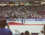
201
Awards podium at Nationals, 1993.
1993
uum_map_usa
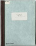
202
Azra [that is, Arza] E. Hinckley journal no. 1, October, 1882 to January, 1884
1882; 1883; 1884; 1885; 1886
Text
uum_msa
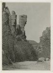
203
B. P. road in Bonita Canyon
1940; 1941; 1942; 1943; 1944; 1945; 1946; 1947; 1948; 1949; 1950; 1951; 1952; 1953; 1954; 1955; 1956; 1957; 1958; 1959; 1960
Image
uum_map
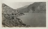
204
Back of Roosevelt Dam
1932-05
Image
uum_map_rr
205
Backpacker on Grand Canyon trail
1961; 1962; 1963; 1964; 1965
Image/StillImage
uum_map_rr
206
Bad Lands (Dolores) near Chinlee. VII, 26 (Photo G271)
1911
Image
uum_map
207
Bad lands, Chinle strata in Hopi Buttes region, north east of Holbrook, Ariz. USGS, probably Darton
1911
Image
uum_map
208
Bad Lands, Cottonwood Wash. 1909
1911
Image
uum_map
209
Bad Lands, Cottonwood Wash. 1909 (photograph from Herbert E. Gregory Book 5: Navajo, 1911)
1911
Image
uum_map
210
Bad Lands, Dolores. Lower Pueblo Colorado Wash. Section VI, 79-80. 1911 (Photo G226)
1911
Image
uum_map
211
Bad Lands. Dolores. Butte No. 24. VI, 76 (Photo G227)
1911
Image
uum_map
212
Balanced boulder, near Navajo Bridge
1932-05-19
Image/StillImage
uum_map
213
Balanced Rock near Lee's Ferry, 1962
1962
Image/StillImage
uum_map_rr
214
Bancroft's map of California, Nevada, Utah and Arizona
1864
Image
uu_awm
215
Banded Navajo sandstone near place where Wingate and Kayenta first lose their identity. Chinle immediately below. Two miles northwest of Pipe Springs, Mohave County, Arizona, 1936.
1936
Image
uum_map
216
Banded Upper LaPlata Black Creek (Photo G390)
1913
Image
uum_map
217
Barking Frog 1
Sound
uu_wss
218
Barrett, Gregory
1900
Image
uum_map
219
Barrett, Gregory, 1900
1900
Image
uum_map
220
Barth, Solomon, biographical sketches: Barth resolution
1928-12-22
Text
uum_msa
221
Basalt cap on Dolores (Triassic) on Holbrook-Keams Canyon road, 9± mi. south of Biddehoche, Arizona, 1909 (photo G-69)
1909
Image
uum_map
222
Basalt, Cedar Springs, AZ. 35± mi. north of Winslow. 1911 (Photo G242)
1911
Image
uum_map
223
Basalt-capped mesa on Dolores (Triassic), 6± miles south of Beddehoche (Indian Wells), Ariz., 1909 (photo G-67)
1909
Image
uum_map
224
Basalt-capped mesa on Dolores (Triassic), 6± miles south of Beddehoche (Indian Wells), Ariz., 1909 (photo G-67)
1909
Image
uum_map
225
Basalt-capped mesa on Dolores (Triassic), 8± miles south of Beddehoche, Ariz., 1909 (photo G-68)
1909
Image
uum_map
201
-
225
of
5,627
<
4
5
6
7
8
9
10
11
12
13
>