| Title | Date | Type | Setname | ||
|---|---|---|---|---|---|
| 76 |
 |
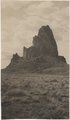
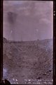
Agathla, volcanic neck, between Chinlee, Ariz. and Oljato, Utah, 1910 (Photo G145) | 1910 | Image | uum_map |
| 77 |
 |
Agathla, volcanic neck, between Chinlee, Ariz. and Oljato, Utah, 1910 (Photo G145) | 1910 | Image | uum_map |
| 78 |
 |
Agathla, volcanic neck, between Chinlee, Ariz. and Oljato, Utah, 1910 (Photo G146) | 1910 | Image | uum_map |
| 79 |
 |
Agathla, volcanic neck, between Chinlee, Ariz. and Oljato, Utah, 1910 (Photo G146) | 1910 | Image | uum_map |
| 80 |
 |
Agathla, volcanic neck, between Chinlee, Ariz. and Oljato, Utah, 1910 (same as G145, Townsend photo) | 1910 | Image | uum_map |
| 81 |
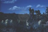 |
Agaves and Joshua trees | 1940; 1941; 1942; 1943; 1944; 1945; 1946; 1947; 1948; 1949; 1950; 1951; 1952; 1953; 1954; 1955; 1956; 1957; 1958; 1959; 1960; 1961; 1962; 1963; 1964; 1965; 1966; 1967; 1968; 1969; 1970; 1971; 1972; 1973; 1974; 1975; 1976; 1977; 1978; 1979; 1980 | Image | uum_map_rr |
| 82 |
 |
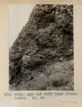
Alluvium with peat. Top wall of Black Creek (VIII-66) (Photo G389) | 1913 | Image | uum_map |
| 83 |
 |
Ancient irrigation ditch, La Plata sandstone, Moencopie wash, 10± mil east of Tuba, Ariz., 1909 (photo G-101) | 1909 | Image | uum_map |
| 84 |
 |
Ancient landslides, 5± mi. southwest of Sunrise Spgs., Ariz. (photo G-44) | 1909 | Image | uum_map |
| 85 |
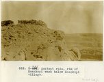 |
Ancient ruin, rim of Moenkopi Wash below Moenkopi village. | 1914 | Image | uum_map |
| 86 |
 |
Apache Indians P.1 | 1885 | Image | dha_cp |
| 87 |
 |
Apache Lodge | 1934 | Image | uum_map_rr |
| 88 |
 |
Arizona department of water resources: Securing Arizona's water future | 1998; 1999; 2000; 2001; 2002; 2003; 2004 | Text; Image | wwdl_er |
| 89 |
 |
Arizona Peace Officer at Short Creek Home | 1953 | Image | dha_cp |
| 90 |
|
Arizona Water Science Center | 2005-01-19 | Text; Image | wwdl_er |
| 91 |
 |
Arizona, Jerome | 1930; 1931; 1932; 1933; 1934; 1935; 1936; 1937; 1938; 1939; 1940; 1941; 1942; 1943; 1944; 1945; 1946; 1947; 1948; 1949; 1950; 1951; 1952; 1953; 1954; 1955; 1956; 1957; 1958; 1959; 1960 | Image | uum_map |
| 92 |
 |
Arizona, Jerome | 1890; 1891; 1892; 1893; 1894; 1895; 1896; 1897; 1898 | Image | uum_map |
| 93 |
 |
Arizona, Tombstone, before 1880 | 1877; 1878; 1879 | Image | uum_map |
| 94 |
 |
Arizona, White Hills [01] | 1940; 1941; 1942; 1943; 1944; 1945; 1946; 1947; 1948; 1949; 1950; 1951; 1952; 1953; 1954; 1955; 1956; 1957; 1958; 1959; 1960; 1961; 1962; 1963; 1964; 1965; 1966; 1967; 1968; 1969; 1970 | Image | uum_map |
| 95 |
 |
Arizona, White Hills [02] | 1940; 1941; 1942; 1943; 1944; 1945; 1946; 1947; 1948; 1949; 1950; 1951; 1952; 1953; 1954; 1955; 1956; 1957; 1958; 1959; 1960; 1961; 1962; 1963; 1964; 1965; 1966; 1967; 1968; 1969; 1970 | Image | uum_map |
| 96 |
 |
Arizona, White Hills [03] | 1940; 1941; 1942; 1943; 1944; 1945; 1946; 1947; 1948; 1949; 1950; 1951; 1952; 1953; 1954; 1955; 1956; 1957; 1958; 1959; 1960; 1961; 1962; 1963; 1964; 1965; 1966; 1967; 1968; 1969; 1970 | Image | uum_map |
| 97 |
 |
Arnold and family (Chinlee) Navajo loom. Heald, photo, 1911 (Photo G282) | 1911 | Image | uum_map |
| 98 |
 |
Arroyo in Cienega (meadow), line of bushes shows position of water table, St. Michaels, Ariz., 1909 (photo G-3) | 1909 | Image | uum_map |
| 99 |
 |
Arroyo in cienega, St. Michaels, Ariz. (negative for G-3) | 1909 | Image | uum_map |
| 100 |
 |
Ash and tuff near Biddehoche. VI, 84 (Photo G231) | 1911 | Image | uum_map |