|
|
Title | Collection Number And Name | Photo Number |
| 201 |
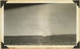 |
View looking west toward Canaan Gap of Short Creek. Road on Arizona-Utah line; foreground, flat cut in lowest Chinle beds; background, cliffs and ridges of eastward dipping Shinarump overlying Moenkopi. Washington County, Utah, 1937. | P0013 Herbert E. Gregory Photograph Collection | P0013n10_171_2386 |
| 202 |
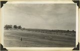 |
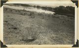
Short Creek near village of Short Creek. Cutting of its channel 20-30 feet done since about 1885. Mohave County, Arizona, 1937. | P0013 Herbert E. Gregory Photograph Collection | P0013n10_172_2387 |
| 203 |
 |
Same as 799 (Short Creek near village of Short Creek. Cutting of its channel 20-30 feet done since about 1885. Mohave County, Arizona, 1937). Point of Vermillion Cliff in upper left. | P0013 Herbert E. Gregory Photograph Collection | P0013n10_172_2388 |
| 204 |
 |
View looking across valley of Little Creek. Shinarump capped cliffs along stream. Smithsonian Butte (left). Navajo Cliffs of Zion Park north across Virgin River. Washington County, Utah, 1937. | P0013 Herbert E. Gregory Photograph Collection | P0013n10_173_2389 |
| 205 |
 |
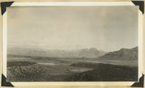
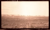
Looking across Big Plains toward Smithsonian Butte (middle background), West Temple (upper right). Foreground forested east slope of Little Creek Mountain, Shinarump; middle distance, dry farm lands on Chinle strata. Washington County, Utah, 1937. | P0013 Herbert E. Gregory Photograph Collection | P0013n10_173_2390 |
| 206 |
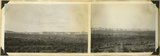 |
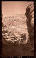
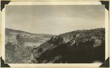
Block mesas from the south, panorama. | P0013 Herbert E. Gregory Photograph Collection | P0013n10_174_2391 |
| 207 |
 |
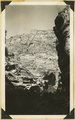
Block mesas from south, panorama. | P0013 Herbert E. Gregory Photograph Collection | P0013n10_174_2391A |
| 208 |
 |
Block mesas from south, panorama. | P0013 Herbert E. Gregory Photograph Collection | P0013n10_174_2391B |
| 209 |
 |
Flax Lake, one of five in landslide northeast of Glendale. Foreground floor of once larger lake. Kane County, Utah, 1937. | P0013 Herbert E. Gregory Photograph Collection | P0013n10_175_2392 |
| 210 |
 |
Wingate, Kayenta, Navajo, Kanab Canyon. | P0013 Herbert E. Gregory Photograph Collection | P0013n10_175_2393 |
| 211 |
 |
Tower in Navajo sandstone, outlier of White Cliffs, Kanab Valley, Kane County, Utah, 1937. | P0013 Herbert E. Gregory Photograph Collection | P0013n10_175_2394 |
| 212 |
 |
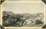
Plateau south of Block Mesas | P0013 Herbert E. Gregory Photograph Collection | P0013n10_176_2395 |
| 213 |
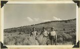 |
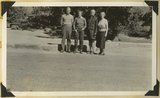
Plateau south of Block mesas. Grantham, Stringham, and guide (right), 1937. | P0013 Herbert E. Gregory Photograph Collection | P0013n10_176_2395 |
| 214 |
 |
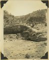
Unconformity---Moenkopi (below) and Shinarump (white) in gulch, 2 miles west of Paria village, Kane County, Utah, 1937. | P0013 Herbert E. Gregory Photograph Collection | P0013n10_176_2396 |
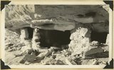
| 215 |
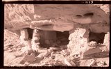 |
Cliff house, Kaibab Gulch, 1937 | P0013 Herbert E. Gregory Photograph Collection | P0013n10_177_2397 |
| 216 |
 |
Cliff house, Kaibab Gulch, 1937 | P0013 Herbert E. Gregory Photograph Collection | P0013n10_177_2397 |
| 217 |
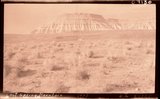 |
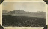
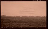
Lost Spring Mountain, 1937. | P0013 Herbert E. Gregory Photograph Collection | P0013n10_177_2398 |
| 218 |
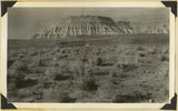 |
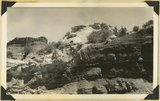
Moenkopi capped by Shinarump, Lost Spring Mountain, 1937. | P0013 Herbert E. Gregory Photograph Collection | P0013n10_177_2398 |
| 219 |
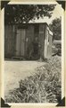 |
Post Office, Virgin City, Utah, 1937. | P0013 Herbert E. Gregory Photograph Collection | P0013n10_178_2399 |
| 220 |
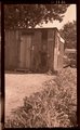 |
Post Office, Virgin, Ut. | P0013 Herbert E. Gregory Photograph Collection | P0013n10_178_2399 |
| 221 |
 |
Lowery and Gregory, Virgin City, 1937. | P0013 Herbert E. Gregory Photograph Collection | P0013n10_178_2400 |
| 222 |
 |
Fremont River Canyon | P0013 Herbert E. Gregory Photograph Collection | P0013n10_179_2401 |
| 223 |
 |
Wall (Moenkopi) of upper Fremont River canyon at deepest part west of Fruita, Utah, 1937. | P0013 Herbert E. Gregory Photograph Collection | P0013n10_179_2401 |
| 224 |
 |
Fremont River canyon west of Fruita (Moenkopi strata), Wayne County, Utah, 1937. | P0013 Herbert E. Gregory Photograph Collection | P0013n10_179_2402 |
| 225 |
 |
Looking up Fremont River canyon west of Fruita, Miners Mesa in middle distance, Wayne County, Utah, 1937. | P0013 Herbert E. Gregory Photograph Collection | P0013n10_180_2403 |