Over 70,000 photos covering a variety of topics from Marriott Library Special Collections
TO
Filters: Date: "1913" Collection: "uum_map"
| Title | Collection Number And Name | Photo Number | ||
|---|---|---|---|---|
| 101 |
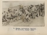 |
Navajo initiation, Chinlee. Dr. Elliott, Photo. 1913. | P0013 Herbert E. Gregory Photograph Collection | P0013n03_76_0502 |
| 102 |
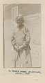 |
Navajo woman. Dr. Elliott, photo. 1913. | P0013 Herbert E. Gregory Photograph Collection | P0013n03_77_0503 |
| 103 |
 |
Herbert E. Gregory Book 6: Navajo, 1913 | P0013 Herbert E. Gregory Photograph Collection | P0013n06 |
| 104 |
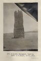 |
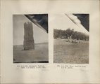
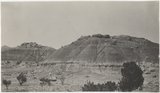
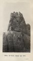
Monument, Todilto Park. K.C.Heald, photo. 1913 (Photo N-M133) | P0013 Herbert E. Gregory Photograph Collection | P0013n06_001_0823 |
| 105 |
 |
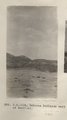
View, Todilto Park. K.C.H. photo (Photo N-M134) | P0013 Herbert E. Gregory Photograph Collection | P0013n06_001_0824 |
| 106 |
 |
Shinarump Conglomerate. Fort Defiance. Heald & Gregory, photo (Photo G307) | P0013 Herbert E. Gregory Photograph Collection | P0013n06_002_0825 |
| 107 |
 |
Shinarump Conglomerate. Fort Defiance. H. & G. photo (Photo G308) | P0013 Herbert E. Gregory Photograph Collection | P0013n06_002_0826 |
| 108 |
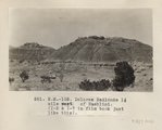 |
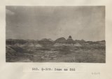
Dolores Badlands 1 1/2 mile west of Nashlini. (I-5 & I-7 in film book just like this) (Photo N-M135) | P0013 Herbert E. Gregory Photograph Collection | P0013n06_003_0827 |
| 109 |
 |
Dolores Badlands 1 1/2 mile west of Nashlini. (I-5 & I-7 in film book just like this) (Photo N-M135) | P0013 Herbert E. Gregory Photograph Collection | P0013n06_003_0827 |
| 110 |
 |
Dolores Badlands west of Nashlini (Photo N-M136) | P0013 Herbert E. Gregory Photograph Collection | P0013n06_004_0828 |
| 111 |
 |
Same as 582 (Dolores Badlands west of Nashlini, Photo G309) | P0013 Herbert E. Gregory Photograph Collection | P0013n06_004_0829 |
| 112 |
 |
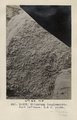
Looking west across wash at Bear Tank. May 26 (Photo G310) | P0013 Herbert E. Gregory Photograph Collection | P0013n06_005_0830 |
| 113 |
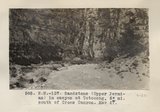 |
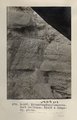
Sandstone (Upper Permian) in canyon at Totocong, 6+ mi. south of Cross Canyon. May 27 (Photo N-M137) | P0013 Herbert E. Gregory Photograph Collection | P0013n06_005_0831 |
| 114 |
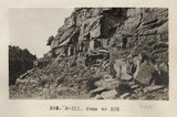 |
Same as 585 (Sandstone in canyon at Totocong, Photo G311) | P0013 Herbert E. Gregory Photograph Collection | P0013n06_005_0832 |
| 115 |
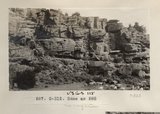 |
Same as 585 (Sandstone in canyon at Totocong, Photo G312) | P0013 Herbert E. Gregory Photograph Collection | P0013n06_006_0833 |
| 116 |
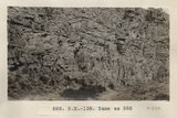 |
Same as 585 (Sandstone in canyon at Totocong, Photo N-M138) | P0013 Herbert E. Gregory Photograph Collection | P0013n06_006_0834 |
| 117 |
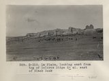 |
La Plata, looking east from top of Dolores Ridge 2± mi. east of Black Rock (Photo G313) | P0013 Herbert E. Gregory Photograph Collection | P0013n06_007_0835 |
| 118 |
 |
La Plata sandstone 2± mi. east of Black Rock (Photo N-M139) | P0013 Herbert E. Gregory Photograph Collection | P0013n06_007_0836 |
| 119 |
 |
Same as 590 (La Plata east of Black Rock, Photo G314) | P0013 Herbert E. Gregory Photograph Collection | P0013n06_008_0837 |
| 120 |
 |
Same as 590 (La Plata east of Black Rock, Photo N-M140) | P0013 Herbert E. Gregory Photograph Collection | P0013n06_008_0838 |
| 121 |
 |
Same as 590 (La Plata east of Black Rock, Photo G315) | P0013 Herbert E. Gregory Photograph Collection | P0013n06_008_0839 |
| 122 |
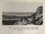 |
Buell's Park from south rim. (I-20 in film book just like this) (Photo N-M141) | P0013 Herbert E. Gregory Photograph Collection | P0013n06_009_0840 |
| 123 |
 |
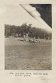
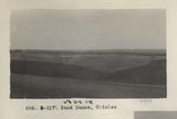
Sand Dunes, Chinlee (Photo G316) | P0013 Herbert E. Gregory Photograph Collection | P0013n06_010_0841 |
| 124 |
 |
Sand Dunes Chinlee (Photo N-M143) | P0013 Herbert E. Gregory Photograph Collection | P0013n06_010_0842 |
| 125 |
 |
Sand Dunes, Chinlee (Photo G317) | P0013 Herbert E. Gregory Photograph Collection | P0013n06_011_0843 |