Home
Browse
Ask Us
Chat
Harmful Language Statement
Log in
Advanced Search
Year
1911
1912
1913
1914
1915
1916
1917
1918
1919
1920
1921
1922
1923
1924
1925
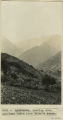
1926
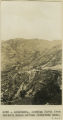
TO
1911
1912
1913
1914
1915
1916
1917
1918
1919
1920
1921
1922
1923
1924
1925
1926
Type
Image
400
Image/StillImage
8
Format
image/jpeg
404
application/pdf
4
Collection
Photo Archives
400
UAIDA Main Collection
8
Filters:
Collection Name:
"Herbert E. Gregory"
Date:
"1913"
1
-
25
of
408
<
1
2
3
4
5
6
7
8
9
10
>
Gallery view
Number of results to display per page
10
25
50
100
200
Sort by Relevance
Sort by Title A-Z
Sort by Title Z-A
Sort by Date Ascending
Sort by Date Descending
Sort by Last Modified Ascending
Sort by Last Modified Descending
Title
Date
Type
Setname
1
"Beast Dike", from southwest (Photo N-M164)
1913
Image
uum_map
2
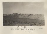
"Beast" dike, from north (Photo G387)
1913
Image
uum_map
3
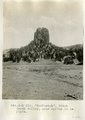
"Beelzebub," Black Creek valley, near spring in La Plata.
1913
Image
uum_map
4
"Comb" from Dike H (Photo G338)
1913
Image
uum_map
5
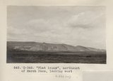
"Flat irons", northeast of Marsh Pass, looking west (Photo G346)
1913
Image
uum_map
6
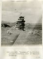
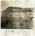
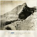
"Monument" in Painted Desert formation east of Tanners Crossing.
1913
Image
uum_map
7
"North Forest", Carrizo Creek Wash (Photo G447)
1913
Image
uum_map
8
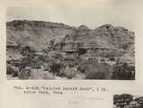
"Painted Desert Bads", 1 mi. below Farm, Tuba (Photo G432)
1913
Image
uum_map
9
"Painted Desert", 2 mi. west of Tuba
1913
Image
uum_map
10
"Painted Desert", four miles west of Tuba
1913
Image
uum_map
11
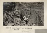
"Trail" out of PahUte canyon (Photo G354)
1913
Image
uum_map
12
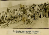
2. Navaho initiation, Chinlee. Dr.Elliott, Photo. 1913
1913
Image/StillImage
uaida_main
13
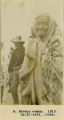
3. Navaho woman. Dr. Elliott, photo., 1913
1913
Image/StillImage
uaida_main
14
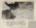
3± mi. north of Tucker Spgs. Green bands in Permian shale just below Shinarump, showing secondary origin. Shinarump in blocks (Photo N-M170)
1913
Image
uum_map
15
4. Navaho child. 1913
1913
Image/StillImage
uaida_main
16
5. Navaho woman. 1913 Dr. Elliott, photo
1913
Image/StillImage
uaida_main
17
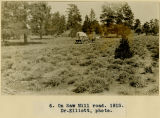
6. On Saw Mill road. 1913. Dr.Elliott, photo
1913
Image/StillImage
uaida_main
18
7. Navaho man. 1913 Dr. Elliott, photo
1913
Image/StillImage
uaida_main
19
8. Navaho man and child. 1913 Dr. Elliott, photo
1913
Image/StillImage
uaida_main
20
9. Navaho belle. 1913 Dr. Elliott, photo
1913
Image/StillImage
uaida_main
21
Alcove in La Plata sandstone, Todilto Park (Photo G382)
1913
Image
uum_map
22
Alluvium with peat. Top wall of Black Creek (VIII-66) (Photo G389)
1913
Image
uum_map
23
Ayusbamba. General view of lake beds looking SE.
1912; 1913; 1914; 1915
Image
uum_map
24
Ayusbamba. Looking down Apurimac Caffon from Calvo's house.
1912; 1913; 1914; 1915
Image
uum_map
25
Ayusbamba. Looking north from Calvo's house across limestone mass.
1912; 1913; 1914; 1915
Image
uum_map
1
-
25
of
408
<
1
2
3
4
5
6
7
8
9
10
>