Home
Browse
Ask Us
Chat
Harmful Language Statement
Log in
Advanced Search
Year
1870
1871
1872
1873
1874
1875
1876
1877
1878
1879
1880
1881
1882
1883
1884
1885
1886
1887
1888
1889
1890
1891
1892
1893
1894
1895
1896
1897
1898
1899
1900
1901
1902
1903
1904
1905
1906
1907
1908
1909
1910
1911
1912
1913
1914
1915
1916
1917
1918
1919
1920
1921
1922
1923
1924
1925
1926
1927
1928
1929
1930
1931
1932
1933
1934
1935
1936
1937
1938
1939
1940
1941
1942
1943
1944
1945
1946
1947
1948
1949
1950
1951
1952
1953
1954
1955
1956
1957
1958
1959
1960
1961
1962
1963
1964
1965
1966
1967
1968
1969
1970
1971
1972
1973
1974
1975
1976
1977
1978
1979
1980
1981
1982
1983
1984
1985
1986
1987
1988
1989
1990
1991
1992
1993
1994
1995
1996
1997
1998
1999
2000
TO
1870
1871
1872
1873
1874
1875
1876
1877
1878
1879
1880
1881
1882
1883
1884
1885
1886
1887
1888
1889
1890
1891
1892
1893
1894
1895
1896
1897
1898
1899
1900
1901
1902
1903
1904
1905
1906
1907
1908
1909
1910
1911
1912
1913
1914
1915
1916
1917
1918
1919
1920
1921
1922
1923
1924
1925
1926
1927
1928
1929
1930
1931
1932
1933
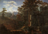
1934
1935
1936
1937
1938
1939
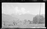
1940
1941
1942
1943
1944
1945
1946
1947
1948
1949
1950
1951
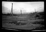
1952
1953
1954
1955
1956
1957
1958
1959
1960
1961
1962
1963
1964
1965
1966
1967
1968
1969
1970
1971
1972
1973
1974
1975
1976
1977
1978
1979
1980
1981
1982
1983
1984
1985
1986
1987
1988
1989
1990
1991
1992
1993
1994
1995
1996
1997
1998
1999
2000
Type
Image/StillImage
525
Image
194
Image/MovingImage
7
Format
image/jpeg
674
video/mp4
7
application/pdf
4
Collection
Art and Art History
166
Clifton Bray Film Negatives
1
George M. Ottinger Photograph Collection
60
Home Movie Collection
3
John Peter Simonson Photograph Collec...
2
Lennox and Catherine Tierney Photogra...
8
Multimedia Archives Photographs - Res...
10
O.L. Tapp Film Collection
4
Photo Archives
9
Ray King Collection
63
Regional History Center
1
Salt Lake Tribune Negative Collection
46
Ski and Snow Sports Photo Archives
9
UAIDA Main Collection
344
Utah River Running Photo Archives
16
More
Filters:
Subject:
"Landscapes"
201
-
225
of
742
<
4
5
6
7
8
9
10
11
12
13
>
Gallery view
Number of results to display per page
10
25
50
100
200
Sort by Relevance
Sort by Title A-Z
Sort by Title Z-A
Sort by Date Ascending
Sort by Date Descending
Sort by Last Modified Ascending
Sort by Last Modified Descending
Title
Date
Type
Setname
201
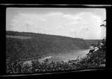
Entry of the Barra de Rio de Janeiro Seen From Santa Teresa, Rua Aprazivel
Image
uu_aah_art
202
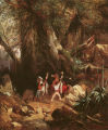
European Travelers Ambushed in a Forest
Image
uu_aah_art
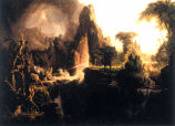
203
Expulsion from the Garden of Eden
Image
uu_aah_art
204
Extensive Landscape with Ruins
Image
uu_aah_art
205
The famous Ute Pass across the Rocky Mountains. The Utes came down this trail to fight the Arapahoes and other plains tribes
1909
Image/StillImage
uaida_main
206
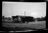
Farm House
1930; 1931; 1932; 1933; 1934; 1935; 1936; 1937; 1938; 1939; 1940
Image/StillImage
dha_rkc
207
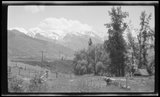
Farm scene, mountains
1910; 1911; 1912; 1913; 1914; 1915; 1916; 1917; 1918; 1919; 1920; 1921; 1922; 1923; 1924; 1925; 1926; 1927; 1928; 1929; 1930; 1931; 1932; 1933; 1934; 1935; 1936; 1937; 1938; 1939; 1940
Image/StillImage
dha_gmo
208
Farm, mountains
1910; 1911; 1912; 1913; 1914; 1915; 1916; 1917; 1918; 1919; 1920; 1921; 1922; 1923; 1924; 1925; 1926; 1927; 1928; 1929; 1930; 1931; 1932; 1933; 1934; 1935; 1936; 1937; 1938; 1939; 1940
Image/StillImage
dha_gmo
209
Farm, mountains
1910; 1911; 1912; 1913; 1914; 1915; 1916; 1917; 1918; 1919; 1920; 1921; 1922; 1923; 1924; 1925; 1926; 1927; 1928; 1929; 1930; 1931; 1932; 1933; 1934; 1935; 1936; 1937; 1938; 1939; 1940
Image/StillImage
dha_gmo
210
Field with Fence
1930; 1931; 1932; 1933; 1934; 1935; 1936; 1937; 1938; 1939; 1940
Image/StillImage
dha_rkc
211
Figure 01: Skull Valley, view from the northwest at, or near Timpie Junction. Jedediah Smith in 1827 climed {sic} the knob in the distance and obtained a glimpse of the Great Salt Lake
1939
Image/StillImage
uum_mapr
212
Figure 02: Knolls, Utah. View southwest. This locality is on the eastern edge of the Great Salt Lake Desert
1939
Image/StillImage
uum_mapr
213
Figure 03: The Bonneville Salt Flats on the Great Salt Lake Desert, Utah. Captain Cobb's world speed record car in the distance
1939
Image/StillImage
uum_mapr
214
Figure 04: Sage Brush in a favorable living locality just south of Skull Valley. This brush is as much as fourteen feet high, indicating a rich soil and a considerable amount of moisture
1939
Image/StillImage
uum_mapr
215
Figure 05: Deep Creek Valley from the Deep Creek Mountains. The Tippets Mountains appear twenty miles westward. The Gosiute village is the center of the picture
1939
Image/StillImage
uum_mapr
216
Figure 06: The Deep Creek Mountains
1939
Image/StillImage
uum_mapr
217
Figure 16: Archaeological sites along the east bank of Fifteen-Mile Creek near the Goshute {sic} Reservation Agency Headquarters
1939
Image/StillImage
uum_mapr
218
Figure 17: Locality of archaeological sites on the west bank of Fifteen-Mile Creek opposite the Gosiute Village. View north
1939
Image/StillImage
uum_mapr
219
Figure 18: The western limit of the Gosiute, the east slope of the Steptoe Mountains in Nevada. View south toward Spring Valley
1939
Image/StillImage
uum_mapr
220
Figure 24: Distant view of a Gosiute house showing a conical "Little House" to the right. A cellar is located on the opposite side
1939
Image/StillImage
uum_mapr
221
First Leaves, Near Mantes
Image
uu_aah_art
222
Flattened Mountain Top
1930; 1931; 1932; 1933; 1934; 1935; 1936; 1937; 1938; 1939; 1940
Image/StillImage
dha_rkc
223
Flood after snakedance-pulling Dodge Powerwagon out of wash [2]
1930; 1931; 1932; 1933; 1934; 1935; 1936; 1937; 1938; 1939; 1940; 1941; 1942; 1943; 1944; 1945; 1946; 1947; 1948; 1949; 1950
Image/StillImage
uaida_main
224
Flood after snakedance-pulling Dodge Powerwagon out of wash [3]
1930; 1931; 1932; 1933; 1934; 1935; 1936; 1937; 1938; 1939; 1940; 1941; 1942; 1943; 1944; 1945; 1946; 1947; 1948; 1949; 1950
Image/StillImage
uaida_main
225
Forest Reduced to Coal
Image
uu_aah_art
201
-
225
of
742
<
4
5
6
7
8
9
10
11
12
13
>