Home
Browse
Ask Us
Chat
Harmful Language Statement
Log in
Advanced Search
Year
1840
1841
1842
1843
1844
1845
1846
1847
1848
1849
1850
1851
1852
1853
1854
1855
1856
1857
1858
1859
1860
1861
1862
1863
1864
1865
1866
1867
1868
1869
1870
1871
1872
1873
1874
1875
1876
1877
1878
1879
1880
1881
1882
1883
1884
1885
1886
1887
1888
1889
1890
1891
1892
1893
1894
1895
1896
1897
1898
1899
1900
1901
1902
1903
1904
1905
1906
1907
1908
1909
1910
1911
1912
1913
1914
1915
1916
1917
1918
1919
1920
1921
1922
1923
1924
1925
1926
1927
1928
1929
1930
1931
1932
1933
1934
1935
1936
1937
1938
1939
1940
1941
1942
1943
1944
1945
1946
1947
1948
1949
1950
1951
1952
1953
1954
1955
1956
1957
1958
1959
1960
1961
1962
1963
1964
1965
1966
1967
1968
1969
1970
1971
1972
1973
1974
1975
1976
1977
1978
1979
1980
1981
1982
1983
1984
1985
1986
1987
1988
1989
1990
1991
1992
1993
1994
1995
1996
1997
1998
1999
2000
2001
2002
2003
2004
2005
2006
2007
2008
TO
1840
1841
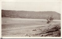
1842
1843
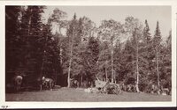
1844
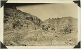
1845
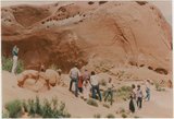
1846
1847
1848
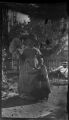
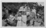
1849
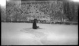
1850
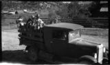
1851
1852
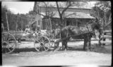
1853
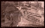
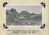
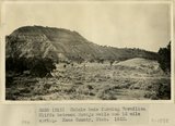
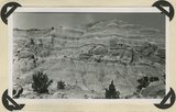
1854
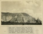
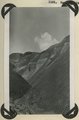
1855
1856
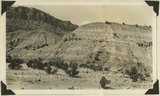
1857
1858
1859
1860
1861
1862
1863
1864
1865
1866
1867
1868
1869
1870
1871
1872
1873
1874
1875
1876
1877
1878
1879
1880
1881
1882
1883
1884
1885
1886
1887
1888
1889
1890
1891
1892
1893
1894
1895
1896
1897
1898
1899
1900
1901
1902
1903
1904
1905
1906
1907
1908
1909
1910
1911
1912
1913
1914
1915
1916
1917
1918
1919
1920
1921
1922
1923
1924
1925
1926
1927
1928
1929
1930
1931
1932
1933
1934
1935
1936
1937
1938
1939
1940
1941
1942
1943
1944
1945
1946
1947
1948
1949
1950
1951
1952
1953
1954
1955
1956
1957
1958
1959
1960
1961
1962
1963
1964
1965
1966
1967
1968
1969
1970
1971
1972
1973
1974
1975
1976
1977
1978
1979
1980
1981
1982
1983
1984
1985
1986
1987
1988
1989
1990
1991
1992
1993
1994
1995
1996
1997
1998
1999
2000
2001
2002
2003
2004
2005
2006
2007
2008
Type
Image
1,280
Image/StillImage
116
Text
53
Sound
2
Format
image/jpeg
1,392
application/pdf
115
video/mp4
2
Collection
Beckwith Photograph Collection
9
Glen Canyon
1
Hiram B. Clawson Papers
1
Mormon Settlement in Arizona
2
Photo Archives
1,304
UAIDA Main Collection
2
Utah Humanities Research Foundation
2
Utah Quilt Heritage Records
44
Utah River Running Photo Archives
139
Western Soundscape
2
Western Waters NEH
2
Westminster University Photographs
2
More
Filters:
Spatial Coverage:
"Kane County (Utah)"
176
-
200
of
1,510
<
3
4
5
6
7
8
9
10
11
12
>
Gallery view
Number of results to display per page
10
25
50
100
200
Sort by Relevance
Sort by Title A-Z
Sort by Title Z-A
Sort by Date Ascending
Sort by Date Descending
Sort by Last Modified Ascending
Sort by Last Modified Descending
Title
Date
Type
Setname
176
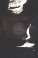
Cathedral in the Desert, whole interior [3]
1965-09-21
Image
uum_map
177
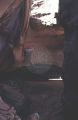
Cathedral in the Desert, whole interior [4]
1965-09-21
Image
uum_map
178
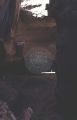
Cathedral in the Desert, whole interior [5]
1965-09-21
Image
uum_map
179
Cathedral in the Desert, whole interior [6]
1965-09-21
Image
uum_map
180
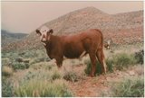
Cattle on the range near Escalante, Utah
1985-05-10; 1985-05-11; 1985-05-12
Image
uum_map
181
Cave Lakes Canyon, 1936
1936
Image
uum_map
182
Cedar Breaks, June 1919: Navajo Lake
1919-06
Image/StillImage
uum_map
183
Cedar Breaks, June 1919: Party camped at Duck Springs
1919-06
Image/StillImage
uum_map
184
Ceremony at Dance Hall Rock
1985-05-10; 1985-05-11; 1985-05-12
Image
uum_map
185
Charles Cutler Esplin on the right, likely with Alvin Porter - about 1930
1925; 1926; 1927; 1928; 1929; 1930; 1931; 1932; 1933; 1934; 1935
Image
uum_map
186
Chevron quilt
1950; 1951; 1952; 1953; 1954; 1955; 1956; 1957; 1958; 1959; 1960; 1961; 1962; 1963; 1964; 1965; 1966; 1967; 1968; 1969; 1970; 1971; 1972; 1973; 1974; 1975; 1976; 1977; 1978; 1979; 1980; 1981; 1982; 1983; 1984; 1985; 1986; 1987; 1988
Text
uum_uqhr
187
Child
Image
uum_map
188
Child making snowballs in Orderville
Image
uum_map
189
Children in the bed of a truck - Orderville
Image
uum_map
190
Children sitting on a rock - Orderville school children
Image
uum_map
191
Children sitting on a trailer behind two horses - HWE standing, in front of Sand Street home
Image
uum_map
192
Chile formation, Petrified Forest member, and upper Chinle beds ( upper left). Branch of Road Canyon. Kane County, UT. 1943
1943
Image
uum_map
193
Chimney Park, Dry Valley. Tributary of Paria Canyon. Erosion remnant of 'Sentinel' sandstone capped by Dakota. Kane County, UT. 1922
1922
Image
uum_map
194
Chimney Park, Dry Valley. Tributary to Paria Canyon. Front of plateau. 'Sentinel' sandstone at base of followed upward by Dakota, Mancos and Mesa Verde. Kane County, UT. 1922
1922
Image
uum_map
195
Chinle beds at base of Vermillion Cliffs between Navajo wells and 16 mile spring. Kane County, UT. 1922
1922
Image
uum_map
196
Chinle beds forming Vermillion Cliffs between Navajo wells and 16 mile spring. Kane County, UT. 1922
1922
Image
uum_map
197
Chinle formation 2 miles northwest abandoned village of Paria. Kane County, UT. 1943
1943
Image
uum_map
198
Chinle formation at "Petrified Forest" near "Sixteen mile Spring," Kane County, Utah, 1931.
1931
Image
uum_map
199
Chinle formation near Clarks Ranch 10+ miles east of Johnson Canyon. Kane County, Utah, 1931.
1931
Image
uum_map
200
Chinle formation, Petrified Forest member. Head of Fossil Wood Creek. Kane County, UT. 1943
1943
Image
uum_map
176
-
200
of
1,510
<
3
4
5
6
7
8
9
10
11
12
>