Home
Browse
Ask Us
Chat
Harmful Language Statement
Log in
Advanced Search
Year
1919
1920
1921
1922
1923
1924
1925
1926
1927
1928
1929
1930
1931
1932
1933
1934
1935
1936
1937
1938
1939
1940
1941
1942
1943
1944
1945
1946
1947
1948
1949
1950
1951
1952
1953
1954
1955
1956
1957
1958
1959
1960
1961
1962
1963
1964
1965
1966
1967
1968
1969
1970
1971
1972
1973
1974
1975
1976
1977
1978
1979
1980
1981
1982
1983
1984
1985
1986
1987
1988
1989
1990
1991
1992
1993
1994
1995
1996
1997
1998
1999
2000
2001
2002
2003
2004
2005
2006
2007
2008
2009
2010
2011
2012
2013
2014
TO
1919
1920
1921
1922
1923
1924
1925
1926
1927
1928
1929
1930
1931
1932
1933
1934
1935
1936
1937
1938
1939
1940
1941
1942
1943
1944
1945
1946
1947
1948
1949
1950
1951
1952
1953
1954
1955
1956
1957
1958
1959
1960
1961
1962
1963
1964
1965
1966
1967
1968
1969
1970
1971
1972
1973
1974
1975
1976
1977
1978
1979
1980
1981
1982
1983
1984
1985
1986
1987
1988
1989
1990
1991
1992
1993
1994
1995
1996
1997
1998
1999
2000
2001
2002
2003
2004
2005
2006
2007
2008
2009
2010
2011
2012
2013
2014
Type
Image/StillImage
35
Text
1
Format
application/pdf
24
image/jpeg
12
Collection
Theses & Dissertations
1
Thorne Photographs
1
Uintah County Regional History Center...
34
Filters:
Subject:
"Mine"
1
-
25
of
36
<
1
2
>
Gallery view
Number of results to display per page
10
25
50
100
200
Sort by Relevance
Sort by Title A-Z
Sort by Title Z-A
Sort by Date Ascending
Sort by Date Descending
Sort by Last Modified Ascending
Sort by Last Modified Descending
Title
Date
Type
Setname
1
American Gilsonite Co Property Survey Located In Section 15 & 16, T9S R24E, Uintah County, Utah
1974
Image/StillImage
ucl_maps
2
Application of genetic algorithms to determine the best combination of main and booster fans
2014-12
Text
ir_etd
3
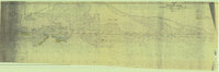
Bonanza - Rainbow Area Mine
1973; 1980
Image/StillImage
ucl_maps
4
Cowboy #1 Detail of Shaft and Cross Section, 1994
1994
Image/StillImage
ucl_maps
5
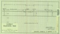
Cowboy - Bandana Gilsonite Vein Plan View and Profile View, 1993
1993
Image/StillImage
ucl_maps
6
Cowboy Gilsonite Vein Section 33, T8S, R24E, S.L.B.&M. 1994
1994
Image/StillImage
ucl_maps
7
Cowboy Vein Shaft No 1 Horizontal & Vertical Deviation Plat, 1995
1995
Image/StillImage
ucl_maps
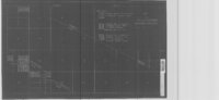
8
Cowboy Vein Vertical Hole 71-3 Geologic Section
1975
Image/StillImage
ucl_maps
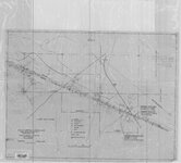
9
Cowboy-Eureka Gilsonite Vein Plane Table Survey, 1980
1980
Image/StillImage
ucl_maps
10
Dragon Area, R25E, Property Map
Image/StillImage
ucl_maps
11
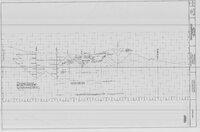
Engineering Cross Section on the Rainbow & Pride-of-the-West Gilsonite Vein
1978
Image/StillImage
ucl_maps
12
Geologic Cross Section of the Cowboy Gilsonite Vein (Hand Drawn)
1960
Image/StillImage
ucl_maps
13
Gilsonite Vein System - Geologic Map of the Ute Area
1977
Image/StillImage
ucl_maps
14
Little Bonanza Gilsonite Mines Layout Plat - Ziegler Chemical & Mineral Corp
1987; 1995; 1996
Image/StillImage
ucl_maps
15
Little Bonanza Mine #1 Combined with Shaft #8 & #8-A (Ziegler Chemical & Mineral Corp)
1991
Image/StillImage
ucl_maps
16
Little Bonanza Mine - Ziegler Chemical & Mineral Corp
1991
Image/StillImage
ucl_maps
17
Little Emma Middle #1 - Ziegler Chemical & Mineral Corp
1992
Image/StillImage
ucl_maps
18
Little Emma Vein - Plane Table Sheet (American Gilsonite, Uintah, Utah)
Image/StillImage
ucl_maps
19
Little Emma Vein - Tom Taylor Mines Exhibit 2 of 2
Image/StillImage
ucl_maps
20
Little Emma Vein - Tom Taylor Mines Profile Exhibit 1 of 2
Image/StillImage
ucl_maps
21
Map of Dragon Mine - American Asphalt Association - Dragon, Utah
1919
Image/StillImage
ucl_maps
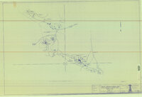
22
Map of Little Bonanza Gilsonite District
Image/StillImage
ucl_maps
23
Map Showing Geologic Structure of Rainbow - Bonanza - Black Dragon Areas, Uintah County, Utah
1978
Image/StillImage
ucl_maps
24
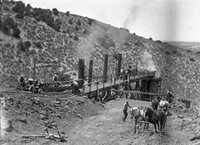
Men Work at Mine
1930; 1931; 1932; 1933; 1934; 1935; 1936; 1937; 1938; 1939; 1940
Image/StillImage
ucl_tp
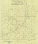
25
Profile Map of the Country Boy Mine (copy of original)
Image/StillImage
ucl_maps
1
-
25
of
36
<
1
2
>