|
|
Title | Date | Type | Setname |
| 1 |
 |
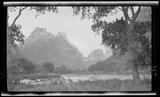
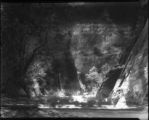
Canyon walls near river, Zion National Park | 1917; 1918; 1919; 1920; 1921; 1922; 1923; 1924; 1925; 1926; 1927; 1928; 1929; 1930; 1931; 1932; 1933; 1934; 1935; 1936; 1937 | Image/StillImage | dha_gmo |
| 2 |
 |
Rock formation and river at Zion National Park | 1917; 1918; 1919; 1920; 1921; 1922; 1923; 1924; 1925; 1926; 1927; 1928; 1929; 1930; 1931; 1932; 1933; 1934; 1935; 1936; 1937 | Image/StillImage | dha_gmo |
| 3 |
 |
Rock walls, river, and trees | 1917; 1918; 1919; 1920; 1921; 1922; 1923; 1924; 1925; 1926; 1927; 1928; 1929; 1930; 1931; 1932; 1933; 1934; 1935; 1936; 1937 | Image/StillImage | dha_gmo |
| 4 |
 |
Rock walls and river | 1917; 1918; 1919; 1920; 1921; 1922; 1923; 1924; 1925; 1926; 1927; 1928; 1929; 1930; 1931; 1932; 1933; 1934; 1935; 1936; 1937 | Image/StillImage | dha_gmo |
| 5 |
 |
River near Zion Canyon | 1917; 1918; 1919; 1920; 1921; 1922; 1923; 1924; 1925; 1926; 1927; 1928; 1929; 1930; 1931; 1932; 1933; 1934; 1935; 1936; 1937 | Image/StillImage | dha_gmo |
| 6 |
 |
Rock wall of Zion National Park | 1917; 1918; 1919; 1920; 1921; 1922; 1923; 1924; 1925; 1926; 1927; 1928; 1929; 1930; 1931; 1932; 1933; 1934; 1935; 1936; 1937 | Image/StillImage | dha_gmo |
| 7 |
 |
Rock walls near river, Zion National Park | 1917; 1918; 1919; 1920; 1921; 1922; 1923; 1924; 1925; 1926; 1927; 1928; 1929; 1930; 1931; 1932; 1933; 1934; 1935; 1936; 1937 | Image/StillImage | dha_gmo |
| 8 |
 |
Rock formation with cliff near river, Zion National Park | 1917; 1918; 1919; 1920; 1921; 1922; 1923; 1924; 1925; 1926; 1927; 1928; 1929; 1930; 1931; 1932; 1933; 1934; 1935; 1936; 1937 | Image/StillImage | dha_gmo |
| 9 |
 |
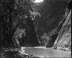
River through Canyon, Zion National Park | 1917; 1918; 1919; 1920; 1921; 1922; 1923; 1924; 1925; 1926; 1927; 1928; 1929; 1930; 1931; 1932; 1933; 1934; 1935; 1936; 1937 | Image/StillImage | dha_gmo |
| 10 |
 |
Zion National Park, Farthest up | 1920-06-20 | Image/StillImage | dha_scnpp |
| 11 |
 |
Zion National Park, General | 1920-07-20 | Image/StillImage | dha_scnpp |
| 12 |
 |
Zion National Park, General | 1920-07-20 | Image/StillImage | dha_scnpp |
| 13 |
 |
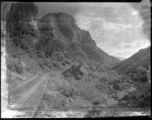
Zion National Park, El Gobernador through saddle | 1921-10-06 | Image/StillImage | dha_scnpp |
| 14 |
 |
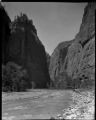
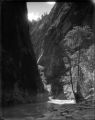
Zion National Park, The Narrows | 1921-10-06 | Image/StillImage | dha_scnpp |
| 15 |
 |
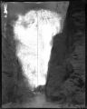
Zion National Park, Looking down from the narrows | 1921-10-06 | Image/StillImage | dha_scnpp |
| 16 |
 |
Zion National Park, Narrows looking down | 1921-10-06 | Image/StillImage | dha_scnpp |
| 17 |
 |
Zion National Park, Mountain of Mystery | 1921-10-06 | Image/StillImage | dha_scnpp |
| 18 |
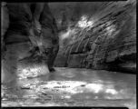 |
Zion National Park, The Narrows | 1921-10-06 | Image/StillImage | dha_scnpp |
| 19 |
 |
Zion National Park, Looking down Canyon from below camp | 1921-10-07 | Image/StillImage | dha_scnpp |
| 20 |
 |
View of the Virgin River a few miles below the mouth of Zion Canyon, showing washed-out banks where farms once stood. Village of Grafton on the opposite side was once the center of a farming area. | 1930; 1931; 1932; 1933; 1934; 1935; 1936; 1937 | Image | uum_map |
| 21 |
 |
Source of the Virgin River. Looking northwest along Cascade Falls Trail. Spring issues from Wasatch limestone cliffs of Markagunt Plateau. Garfield County, Utah, 1937. | 1937 | Image | uum_map |
| 22 |
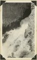 |
Cascade Falls, source of Virgin River. Point of emergence from Wasatch limestone. Garfield County, Utah, 1937. | 1937 | Image | uum_map |
| 23 |
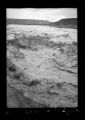 |
Floods, Virgin River -Shot 1 | 1938-03-05 | Image/StillImage | dha_sltnc |
| 24 |
 |
Floods, Virgin River -Shot 2 | 1938-03-05 | Image/StillImage | dha_sltnc |
| 25 |
 |
Floods, Virgin River -Shot 3 | 1938-03-05 | Image/StillImage | dha_sltnc |