| Title | Date | Type | Setname | ||
|---|---|---|---|---|---|
| 1 |
 |
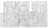
Map of the Northern Part of the Former Uintah Indian Reservation Showing the Irrigation System | Image/StillImage | uaida_main | |
| 2 |
 |
Map of the Uintah Basin and the Uintah Ouray Reservation | Image/StillImage | uaida_main | |
| 3 |
 |
Map of Dry Gulch Irrigation District, Uintah Indian Reservation, Utah | Image/StillImage | uaida_main | |
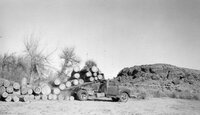
| 4 |
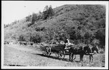 |
Wagon hauling timber | 1900; 1901; 1902; 1903; 1904; 1905; 1906; 1907; 1908; 1909; 1910; 1911; 1912; 1913; 1914; 1915; 1916; 1917; 1918; 1919; 1920 | Image/StillImage | dha_rucc |
| 5 |
 |
Lake | 1910; 1911; 1912; 1913; 1914; 1915; 1916; 1917; 1918; 1919; 1920; 1921; 1922; 1923; 1924; 1925; 1926; 1927; 1928; 1929; 1930; 1931; 1932; 1933; 1934; 1935; 1936; 1937; 1938; 1939; 1940 | Image/StillImage | dha_gmo |
| 6 |
 |
Mountain stream, winter | 1910; 1911; 1912; 1913; 1914; 1915; 1916; 1917; 1918; 1919; 1920; 1921; 1922; 1923; 1924; 1925; 1926; 1927; 1928; 1929; 1930; 1931; 1932; 1933; 1934; 1935; 1936; 1937; 1938; 1939; 1940 | Image/StillImage | dha_gmo |
| 7 |
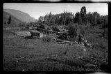 |
Wood Piles | 1930; 1931; 1932; 1933; 1934; 1935; 1936; 1937; 1938; 1939; 1940 | Image/StillImage | dha_rkc |
| 8 |
 |
2004.24.15699 | 1937-06-30 | Image | dha_hpsp |
| 9 |
 |
2004.24.15697 | 1937-06-30 | Image | dha_hpsp |
| 10 |
 |
Man With Horse Team | 1950-10 | Image | ucl_tp |
| 11 |
 |
Timber Trucking Near Ouray | 1964-12-24 | Image/StillImage | ucl_vep |