Home
Browse
Ask Us
Chat
Harmful Language Statement
Log in
Theses & Dissertations
Advanced Search
Year
1950
1951
1952
1953
1954
1955
1956
1957
1958
1959
1960
1961
1962
1963
1964
1965
1966
1967
1968
1969
1970
1971
1972
TO
1950
1951
1952
1953
1954
1955
1956
1957
1958
1959
1960
1961
1962
1963
1964
1965
1966
1967
1968
1969
1970
1971
1972
Type
Image
17
Text
11
Format
application/pdf
11
application/vnd.google-earth.kmz
4
application/zip
1
image/jpeg
1
Collection
Theses & Dissertations
17
Filters:
Subject:
"Thesis and dissertation georeferencing project"
Type:
"Image"
1
-
25
of
17
Gallery view
Number of results to display per page
10
25
50
100
200
Sort by Relevance
Sort by Title A-Z
Sort by Title Z-A
Sort by Date Ascending
Sort by Date Descending
Sort by Last Modified Ascending
Sort by Last Modified Descending
Title
Date
Type
1
Alteration and trace elements of volcanics in the San Francisco Mountains
1964-06
Text; Image
2
Alteration and trace elements of volcanics in the San Francisco Mountains: Georeferenced map files
1964-06
Image
3
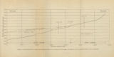
Figure 4: Longitudinal profile of Middle Canyon showing locations of the profiles across the canyon, the nickpoint, and the hypothetical profile before rejuvenation
1960-08
Image
4
Geology and ground-water resources of Ogden Valley, Utah
1972-06
Text; Image
5
Geology of the Cove Creek area Millard County and Beaver County, Utah
1961-06
Text; Image
6
Geology of the Davis Knolls and northern Big Davis Mountain area, Tooele County, Utah
1962-08
Text; Image
7
Geology of the East Canyon area, Morgan County, Utah
1954
Text; Image
8
Geology of the Lost Creek-Echo Canyon Area, Morgan and Summit Counties, Utah
1959-06
Text; Image
9
Geology of the Sheeprock Mountains, Tooele and Juab Counties, Utah
1957-08
Text; Image
10
Geology of the Smith and Morehouse-Hayden Fork area, Utah
1952
Text; Image
11
Geology of the West Tintic mining district and vicinity, Juab County, Utah
1954-06
Text; Image
12
Map 1: Geologic map of Antelope intrusive and vicinity (Google Earth map overlay KMZ file)
1950
Image
13
Parunuweap formation in the vicinity of Zion National Park, Utah (Google Earth map overlay KMZ file)
1969-06
Image
14
Petrology of Lake Bonneville Gravels Salt Lake County, Utah
1963-05
Text; Image
15
Plate 1: Lucin mining district and vicinity, Northern Pilot Range, Box Elder County, Utah - Elko County, Nevada (Google Earth map overlay KMZ file)
1960-08
Image
16
Plate 1B: Geologic map of the Central and Southern Silver Island Mountains, Box Elder and Tooele Counties, Utah, and Elko County, Nevada (Google Earth map overlay KMZ file)
1961-06
Image
17
Sedimentology and geomorphic significance of the bishop conglomerate and the Browns Park Formation, Eastern Uinta Mountains, Utah, Colorado, And Wyoming (Thesis and maps)
1970-06
Text; Image
1
-
25
of
17