Home
Browse
Ask Us
Chat
Harmful Language Statement
Log in
Theses & Dissertations
Advanced Search
Year
1950
1951
1952
1953
1954
1955
1956
1957
1958
1959
1960
1961
1962
1963
1964
1965
1966
1967
1968
1969
1970
1971
1972
1973
1974
1975
1976
1977
1978
1979
1980
1981
1982
1983
1984
1985
1986
1987
1988
1989
1990
1991
1992
1993
1994
1995
1996
1997
1998
1999
2000
2001
2002
2003
2004
2005
2006
2007
2008
2009
2010
TO
1950
1951
1952
1953
1954
1955
1956
1957
1958
1959
1960
1961
1962
1963
1964
1965
1966
1967
1968
1969
1970
1971
1972
1973
1974
1975
1976
1977
1978
1979
1980
1981
1982
1983
1984
1985
1986
1987
1988
1989
1990
1991
1992
1993
1994
1995
1996
1997
1998
1999
2000
2001
2002
2003
2004
2005
2006
2007
2008
2009
2010
Type
Text
47
Image
12
Format
application/pdf
47
application/vnd.google-earth.kmz
1
image/jpeg
1
Collection
Theses & Dissertations
49
Filters:
Subject:
"Thesis and dissertation georeferencing project"
Department:
"Geology & Geophysics"
Publication Type:
"thesis"
1
-
25
of
49
<
1
2
>
Gallery view
Number of results to display per page
10
25
50
100
200
Sort by Relevance
Sort by Title A-Z
Sort by Title Z-A
Sort by Date Ascending
Sort by Date Descending
Sort by Last Modified Ascending
Sort by Last Modified Descending
Title
Date
Type
1
Geology of the Sheeprock Mountains, Tooele and Juab Counties, Utah
1957-08
Text; Image
2
Geology of the Davis Knolls and northern Big Davis Mountain area, Tooele County, Utah
1962-08
Text; Image
3
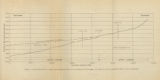
Figure 4: Longitudinal profile of Middle Canyon showing locations of the profiles across the canyon, the nickpoint, and the hypothetical profile before rejuvenation
1960-08
Image
4
Plate 1B: Geologic map of the Central and Southern Silver Island Mountains, Box Elder and Tooele Counties, Utah, and Elko County, Nevada (Google Earth map overlay KMZ file)
1961-06
Image
5
Geology of the Smith and Morehouse-Hayden Fork area, Utah
1952
Text; Image
6
Sedimentology and geomorphic significance of the bishop conglomerate and the Browns Park Formation, Eastern Uinta Mountains, Utah, Colorado, And Wyoming (Thesis and maps)
1970-06
Text; Image
7
Geology of the Cove Creek area Millard County and Beaver County, Utah
1961-06
Text; Image
8
Petrology of Lake Bonneville Gravels Salt Lake County, Utah
1963-05
Text; Image
9
Geology of the Durst Mountain-Huntsville area Morgan and Weber Counties, Utah
1957-08
Text
10
Geology of the East Canyon area, Morgan County, Utah
1954
Text; Image
11
Geology and diatremes of Desert Mountain, Utah
1971-06
Text
12
Geology and geothermal potential of the Roosevelt Hot Springs area, Beaver County, Utah
1975
Text
13
Geology of the West Tintic mining district and vicinity, Juab County, Utah
1954-06
Text; Image
14
Geology of the West Tintic Range and vicinity, Tooele and Juab Counties, Utah
1959-06
Text
15
Hydrology of middle Canyon, Oquirrh Mountains, Tooele County, Utah
1960-08
Text
16
General geology and sulfide mineralization of Dry Canyon and vicinity, Gunnison Plateau, Sanpete Co., Utah
1967-06
Text
17
Sedimentology of the Dakota Formation (Cretaceous), Uinta Mountains, Northeastern Utah
1973-12
Text
18
Stratigraphy of the Currant Creek Formation, Wasatch and Duchesne Counties, Utah
1967-08
Text
19
Geology and ground-water resources of Ogden Valley, Utah
1972-06
Text; Image
20
Geology of the Lost Creek-Echo Canyon Area, Morgan and Summit Counties, Utah
1959-06
Text; Image
21
A faunule from a Shale Unit in the lower Ely Formation, West-Central Utah
1967-06
Text
22
Carbonate petrology of the Green River Formation (Eocene), Uinta Basin, Utah and Colorado
1972-08
Text
23
The geology of Antimony Canyon area Garfield and Piute Counties, Utah
2010
Text
24
Correlation of tuff layers in the Green River Formation, Utah, using biotite compositions
1974
Text
25
Geology of a part of Northwestern Uinta County, Wyoming
1961-06
Text
1
-
25
of
49
<
1
2
>