| Title | Date | Type | Setname | ||
|---|---|---|---|---|---|
| 1 |
 |
A case analysis of policy implementation: the National Environmental Policy Act of 1969 | 1975 | Text | uu_gc |
| 2 |
 |
Aerial view of covered marina and building, "red rock" landscape and water and buoys | 1967; 1968; 1969; 1970; 1971; 1972; 1973; 1974; 1975 | Image/StillImage | uum_map |
| 3 |
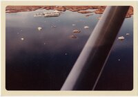 |
Aerial view of covered marina and building, surrounding landscape with water, buoys, and boats | 1967; 1968; 1969; 1970; 1971; 1972; 1973; 1974; 1975 | Image/StillImage | uum_map |
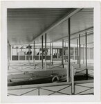
| 4 |
 |
Aerial view of Lake Powell | 1964; 1965; 1966; 1967; 1968; 1969; 1970; 1971; 1972; 1973; 1974; 1975 | Image/StillImage | uum_map |
| 5 |
 |
Aerial view of marina [1] | 1967; 1968; 1969; 1970; 1971; 1972; 1973; 1974; 1975 | Image/StillImage | uum_map |
| 6 |
 |
Aerial view of marina [2] | 1967; 1968; 1969; 1970; 1971; 1972; 1973; 1974; 1975 | Image/StillImage | uum_map |
| 7 |
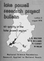 |
Air quality in the Lake Powell region | 1974 | Text | uu_gc |
| 8 |
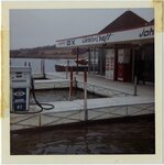
 |
Boat parked at a dock next to building, large chest labeled "ICE," long ramp and lawn in the background | 1967; 1968; 1969; 1970; 1971; 1972; 1973; 1974; 1975 | Image/StillImage | uum_map |
| 9 |
 |
Boating on Lake Powell amid red rock cliffs | 1964; 1965; 1966; 1967; 1968; 1969; 1970; 1971; 1972; 1973; 1974; 1975 | Image/StillImage | uum_map |
| 10 |
 |
Building with "DX" printed on it in front of slope leading to road or parking lot | 1967; 1968; 1969; 1970; 1971; 1972; 1973; 1974; 1975 | Image/StillImage | uum_map |
| 11 |
 |
Covered marina with multiple slips in front of building | 1967; 1968; 1969; 1970; 1971; 1972; 1973; 1974; 1975 | Image/StillImage | uum_map |
| 12 |
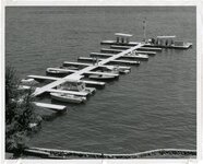 |
Dock with boat slips, six fuel pumps, communication or navigation tower, one pontoon boat and seven other boats, and two men walking | 1967; 1968; 1969; 1970; 1971; 1972; 1973; 1974; 1975 | Image/StillImage | uum_map |
| 13 |
 |
Glen Canyon Dam Crack Ceremony. Edward Abbey collection | 1981-03-21 | Sound | uum_avacr |
| 14 |
 |
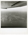
High-altitude aerial photo of Lake Powell | 1964; 1965; 1966; 1967; 1968; 1969; 1970; 1971; 1972; 1973; 1974; 1975 | Image/StillImage | uum_map |
| 15 |
 |
The impact of power developments on the Navajo nation | 1975 | Text | uu_gc |
| 16 |
 |
Inside covered marina with multiple slips | 1967; 1968; 1969; 1970; 1971; 1972; 1973; 1974; 1975 | Image/StillImage | uum_map |
| 17 |
 |
Inside covered marina with multiple slips in front of building | 1964; 1965; 1966; 1967; 1968; 1969; 1970; 1971; 1972; 1973; 1974; 1975 | Image/StillImage | uum_map |
| 18 |
 |
Lake Powell | 1950; 1951; 1952; 1953; 1954; 1955; 1956; 1957; 1958; 1959; 1960 | Image/StillImage | dha_alwmc |
| 19 |
 |
Logo design showing blue-green frog in circle | 1964; 1965; 1966; 1967; 1968; 1969; 1970; 1971; 1972; 1973; 1974; 1975 | Image/StillImage | uum_map |
| 20 |
 |
Management of scientific collaboration in the Lake Powell Research Project | 1975 | Text | uu_gc |
| 21 |
 |
Map of Bullfrog Basin Development by Young & Fowler Associates | 1963; 1964; 1965; 1966; 1967 | Image/StillImage | uum_map |
| 22 |
 |
Map of Bullfrog Basin with "Lake Powell" hand-lettered at upper left and colored legend identifying service station, marina, and motel and an inset of map showing Southern Utah | 1964 | Image/StillImage | uum_map |
| 23 |
 |
Marina building with "Chris Craft" and "Johnson" printed on it, two men standing on the attached dock | 1967; 1968; 1969; 1970; 1971; 1972; 1973; 1974; 1975 | Image/StillImage | uum_map |
| 24 |
 |
Marina building with "Port DX," "Chris Craft" and "Johnson" printed on it and fuel pump on dock | 1967; 1968; 1969; 1970; 1971; 1972; 1973; 1974; 1975 | Image/StillImage | uum_map |
| 25 |
 |
Marina showing the dock, covered gazebo, water and trees | 1967; 1968; 1969; 1970; 1971; 1972; 1973; 1974; 1975 | Image/StillImage | uum_map |