Home
Browse
Ask Us
Chat
Harmful Language Statement
Log in
Advanced Search
Year
2008
2009
2010
2011
2012
2013
2014
2015
2016
2017
2018
2019
2020
2021
2022
2023
TO
2008
2009
2010
2011
2012
2013
2014
2015
2016
2017
2018
2019
2020
2021
2022
2023
Type
Text
20
Image
1
Format
application/pdf
20
Collection
Department of City and Metropolitan P...
4
Theses & Dissertations
13
UScholar Works
2
Westminster College Institutional Rep...
1
Filters:
Subject:
"GIS"
Type:
"Text"
1
-
25
of
20
Gallery view
Number of results to display per page
10
25
50
100
200
Sort by Relevance
Sort by Title A-Z
Sort by Title Z-A
Sort by Date Ascending
Sort by Date Descending
Sort by Last Modified Ascending
Sort by Last Modified Descending
Title
Date
Type
Setname
1
A digital atlas of Utah wilderness
2011-12
Text
ir_etd
2
An interactive visualization tool for mobile objects
2010-08
Text
ir_etd
3
Anthropogenic habitat disturbance and the dynamics of hantavirus using remote sensing, GIS, and a spatially explicit agent-based model
2010-08
Text
ir_etd
4
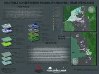
Connection to Conservation: How Conservation Easements can Help with Social Equity Issues and Provide Accessibility
2021
Text
ir_cmp
5
Connection to conservation: how conservation easements can help with social equity issues and provide accessibility
2021
Text
ir_cmp
6
Creating spatial data infrastructure to facilitate the collection and dissemination of geospatial data to aid in disaster management
2015-05
Text
ir_etd
7
Geographic information system spatial-temporal evolution of multiscalar patterns and determinants of foreign direct investment in China
2014-08
Text
ir_etd
8
Modeling wildfire evacuation as a coupled human-environmental system using triggers
2016
Text
ir_etd
9
Modeling wildfire evacuation as a coupled human-environmental system using triggers
2016
Text
ir_etd
10
Predictive models for strontium isotope distributions in bedrock, water and environmental materials for regional provenance studies
2014-12
Text
ir_etd
11
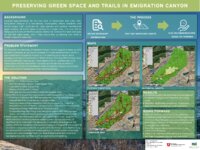
Preserving greenspace and trails in Emigration Canyon
2023
Text
ir_cmp
12
Preserving greenspace and trails in Emigration Canyon
2023
Text
ir_cmp
13
Recent trends in the changing geographic extent of Cienegas of the United States/Mexico border region
2011-05
Text
ir_etd
14
Refugee Integration and Maps: Learning from Lived Experiences to Connect People and Resources
2018-10
Text; Image
wc_ir
15
Simplified GIS approach to modeling global leaf water isoscapes
2008
Text
ir_uspace
16
Spatial-temporal hierarchy of regional inequality of China
2010-07
Text
ir_uspace
17
Thinking inside the black box: enhancing the social vulnerability index with an artificial neural network
2015-08
Text
ir_etd
18
Tracking a wildfire in areas of high relief using volunteered geographic information: a viewshed application
2014-05
Text
ir_etd
19
When and where: spatiotemporal analysis of dynamic public transit accessibility along the Wasatch Front
2014-12
Text
ir_etd
20
Wildland firefighter entrapment avoidance: developing evacuation trigger points utilizing the Wildland Urban Interface Evacuation (WUIVAC) fire spread model
2012-05
Text
ir_etd
1
-
25
of
20