Home
Browse
Ask Us
Chat
Harmful Language Statement
Log in
Art and Art History
Advanced Search
Type
Image
21
Format
image/jpeg
21
Collection
Art and Art History
21
Filters:
Subject:
"Colonial Latin America"
Type:
"Image"
1
-
25
of
21
Gallery view
Number of results to display per page
10
25
50
100
200
Sort by Relevance
Sort by Title A-Z
Sort by Title Z-A
Sort by Date Ascending
Sort by Date Descending
Sort by Last Modified Ascending
Sort by Last Modified Descending
Title
Date
Type
1
Americae tertia pars memorabilē provinciæ Brasiliæ historiam, Cooking and Eating Scene
Image
2
Americae tertia pars memorabilē provinciæ Brasiliæ historiam, Frontispiece
Image
3
Brazil as Parrots and Trees on Cantino's World Map
Image
4
Brevísima relación de la destrucción de las Indias (A Short Account of the Destruction of the Indies): Image Showing the Destruction of Indian Bodies
Image
5
The Coffee Harvest
Image
6
Founding of São Vicente
Image
7
Founding of the City of São Paulo, 1554
Image
8
Land of Cannibals
Image
9
Map: Areas in northeast Brazil occupied by the Dutch, showing the main regions under Johan Maurits van Nassau's rule, 1637 - 1644
Image
10
Map: Pedro Álvares Cabral's Voyage to and from India with the discovery of Brazil
Image
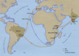
11
Map: Portuguese Voyage Routes, 15th and 16th Century CE
Image
12
Portrait of Johan Maurits van Nassau-Siegen
Image
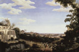
13
Ruins of Olinda
Image
14
Ruins of Olinda (detail)
Image
15
Ruins of the Jesuit Church in Olinda
Image
16
Serro Frio: Slaves Washing Precious Stones
Image
17
Serro Frio: Two Overseers Search a Slave (or Whipping an Enslaved Male)
Image
18
Sugar Mill
Image
19
Sugar Mill (detail)
Image
20
Tiradentes Slaughtered
Image
21
Universalis Cosmographia: Brazil as a River in a Country called "America"
Image
1
-
25
of
21