| Title | Date | Type | Setname | ||
|---|---|---|---|---|---|
| 1 |
 |
Winter mountain trail, Little Cottonwood Canyon | 1930; 1931; 1932; 1933; 1934; 1935; 1936; 1937; 1938; 1939; 1940 | Image/StillImage | uum_map |
| 2 |
 |
Morainic mass extending across Little Cottonwood Canyon | 1910; 1911; 1912; 1913; 1914; 1915; 1916; 1917; 1918; 1919; 1920; 1921; 1922; 1923; 1924; 1925; 1926; 1927; 1928; 1929; 1930; 1931; 1932; 1933; 1934; 1935; 1936; 1937; 1938; 1939; 1940; 1941; 1942; 1943; 1944; 1945 | Image/StillImage | uum_map |
| 3 |
 |
Fault scarp crossing south moraine of Little Cottonwood Canyon | 1910; 1911; 1912; 1913; 1914; 1915; 1916; 1917; 1918; 1919; 1920; 1921; 1922; 1923; 1924; 1925; 1926; 1927; 1928; 1929; 1930; 1931; 1932; 1933; 1934; 1935; 1936; 1937; 1938; 1939; 1940; 1941; 1942; 1943; 1944; 1945 | Image/StillImage | uum_map |
| 4 |
 |
Perched, granite boulders on quartzite formation, Little Cottonwood Canyon | 1910; 1911; 1912; 1913; 1914; 1915; 1916; 1917; 1918; 1919; 1920; 1921; 1922; 1923; 1924; 1925; 1926; 1927; 1928; 1929; 1930; 1931; 1932; 1933; 1934; 1935; 1936; 1937; 1938; 1939; 1940; 1941; 1942; 1943; 1944; 1945 | Image/StillImage | uum_map |
| 5 |
 |
Contact between archaean quartzite and granite, south side of Little Cottonwood Canyon | 1910; 1911; 1912; 1913; 1914; 1915; 1916; 1917; 1918; 1919; 1920; 1921; 1922; 1923; 1924; 1925; 1926; 1927; 1928; 1929; 1930; 1931; 1932; 1933; 1934; 1935; 1936; 1937; 1938; 1939; 1940; 1941; 1942; 1943; 1944; 1945 | Image/StillImage | uum_map |
| 6 |
 |
Faulted crust block near mouth of Little Cottonwood Canyon | 1910; 1911; 1912; 1913; 1914; 1915; 1916; 1917; 1918; 1919; 1920; 1921; 1922; 1923; 1924; 1925; 1926; 1927; 1928; 1929; 1930; 1931; 1932; 1933; 1934; 1935; 1936; 1937; 1938; 1939; 1940; 1941; 1942; 1943; 1944; 1945 | Image/StillImage | uum_map |
| 7 |
 |
Moraine about five miles up Little Cottonwood Canyon | 1910; 1911; 1912; 1913; 1914; 1915; 1916; 1917; 1918; 1919; 1920; 1921; 1922; 1923; 1924; 1925; 1926; 1927; 1928; 1929; 1930; 1931; 1932; 1933; 1934; 1935; 1936; 1937; 1938; 1939; 1940; 1941; 1942; 1943; 1944; 1945 | Image/StillImage | uum_map |
| 8 |
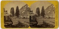 |
Little Cottonwood Canyon : Alta from the east | 1870; 1871; 1872; 1873; 1874; 1875; 1876; 1877; 1878; 1879; 1880; 1881; 1882; 1883; 1884; 1885; 1886; 1887; 1888; 1889; 1890 | Image/StillImage | uum_map |
| 9 |
 |
Little Cottonwood Canyon : looking down the canyon from Superior Gulch | 1870; 1871; 1872; 1873; 1874; 1875; 1876; 1877; 1878; 1879; 1880; 1881; 1882; 1883; 1884; 1885; 1886; 1887; 1888; 1889; 1890 | Image/StillImage | uum_map |
| 10 |
 |
Little Cottonwood Canyon : granite bowlders [that is, boulders] near Wahsatch | 1883; 1884; 1885; 1886; 1887; 1888; 1889; 1890; 1891; 1892; 1893; 1894; 1895; 1896; 1897 | Image/StillImage | uum_map |
| 11 |
 |
Little Cottonwood Canyon : looking down from the Emma Mine | 1883; 1884; 1885; 1886; 1887; 1888; 1889; 1890; 1891; 1892; 1893; 1894; 1895; 1896; 1897 | Image/StillImage | uum_map |
| 12 |
 |
Little Cottonwood Canyon : the tramway shed near Alta | 1883; 1884; 1885; 1886; 1887; 1888; 1889; 1890; 1891; 1892; 1893; 1894; 1895; 1896; 1897 | Image/StillImage | uum_map |
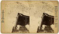
| 13 |
 |
Little Cottonwood Canyon : Sam Tai washing house | 1883; 1884; 1885; 1886; 1887; 1888; 1889; 1890; 1891; 1892; 1893; 1894; 1895; 1896; 1897 | Image/StillImage | uum_map |
| 14 |
 |
Little Cottonwood Canyon : tramway snow sheds, Alta | 1883; 1884; 1885; 1886; 1887; 1888; 1889; 1890; 1891; 1892; 1893; 1894; 1895; 1896; 1897 | Image/StillImage | uum_map |
| 15 |
 |
Little Cottonwood Canyon : the Devil's Elbow | 1883; 1884; 1885; 1886; 1887; 1888; 1889; 1890; 1891; 1892; 1893; 1894; 1895; 1896; 1897 | Image/StillImage | uum_map |
| 16 |
 |
Little Cottonwood Canyon : Alta | 1883; 1884; 1885; 1886; 1887; 1888; 1889; 1890; 1891; 1892; 1893; 1894; 1895; 1896; 1897 | Image/StillImage | uum_map |
| 17 |
 |
Little Cottonwood Canyon : looking up from near Wahsatch | 1883; 1884; 1885; 1886; 1887; 1888; 1889; 1890; 1891; 1892; 1893; 1894; 1895; 1896; 1897 | Image/StillImage | uum_map |
| 18 |
 |
Little Cottonwood Canyon : tramway | 1883; 1884; 1885; 1886; 1887; 1888; 1889; 1890; 1891; 1892; 1893; 1894; 1895; 1896; 1897 | Image/StillImage | uum_map |
| 19 |
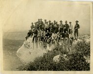 |
University of Utah, geology fieldwork [01] | 1918-05 | Image/StillImage | uum_map |
| 20 |
 |
University of Utah, geology fieldwork [04] | 1918; 1919; 1920 | Image/StillImage | uum_map |
| 21 |
 |
Skiers at head of Mill B Fork | 1920; 1921; 1922; 1923; 1924; 1925; 1926; 1927; 1928; 1929; 1930; 1931; 1932; 1933; 1934; 1935; 1936; 1937; 1938; 1939; 1940; 1941; 1942; 1943; 1944; 1945; 1946; 1947; 1948; 1949; 1950 | uum_map_usa | |
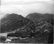
| 22 |
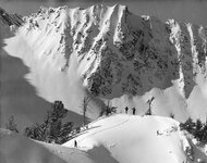 |
En route to Cardiac Ridge | 1920; 1921; 1922; 1923; 1924; 1925; 1926; 1927; 1928; 1929; 1930; 1931; 1932; 1933; 1934; 1935; 1936; 1937; 1938; 1939; 1940; 1941; 1942; 1943; 1944; 1945; 1946; 1947; 1948; 1949; 1950 | uum_map_usa | |
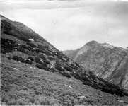
| 23 |
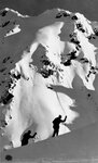 |
En route to Cardiac Ridge | 1920; 1921; 1922; 1923; 1924; 1925; 1926; 1927; 1928; 1929; 1930; 1931; 1932; 1933; 1934; 1935; 1936; 1937; 1938; 1939; 1940; 1941; 1942; 1943; 1944; 1945; 1946; 1947; 1948; 1949; 1950 | uum_map_usa | |
| 24 |
 |
Skiers at Gad Valley | 1920; 1921; 1922; 1923; 1924; 1925; 1926; 1927; 1928; 1929; 1930; 1931; 1932; 1933; 1934; 1935; 1936; 1937; 1938; 1939; 1940; 1941; 1942; 1943; 1944; 1945; 1946; 1947; 1948; 1949; 1950 | uum_map_usa | |
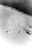
| 25 |
 |
Bob Marsh avalanche study graphs [018] | 1971-11 | Image/StillImage | uum_map_usa |