Home
Browse
Ask Us
Chat
Harmful Language Statement
Log in
University of Utah Marriott Library
Advanced Search
Year
1936
1937
1938
1939
1940
1941
1942
1943
1944
1945
1946
1947
1948
1949
1950
1951
1952
1953
1954
1955
1956
1957
1958
1959
1960
1961
1962
1963
1964
1965
1966
1967
1968
1969
1970
1971
1972
1973
1974
1975
1976
1977
1978
1979
1980
1981
1982
1983
1984
1985
1986
1987
1988
1989
1990
1991
1992
1993
1994
1995
1996
1997
1998
TO
1936
1937
1938
1939
1940
1941
1942
1943
1944
1945
1946
1947
1948
1949
1950
1951
1952
1953
1954
1955
1956
1957
1958
1959
1960
1961
1962
1963
1964
1965
1966
1967
1968
1969
1970
1971
1972
1973
1974
1975
1976
1977
1978
1979
1980
1981
1982
1983
1984
1985
1986
1987
1988
1989
1990
1991
1992
1993
1994
1995
1996
1997
1998
Type
Image
19
Format
image/jpeg
19
Collection
Photo Archives
11
Ski and Snow Sports Archives
8
Filters:
Spatial Coverage:
"Brian Head (Utah)"
Type:
"Image"
1
-
25
of
19
Gallery view
Number of results to display per page
10
25
50
100
200
Sort by Relevance
Sort by Title A-Z
Sort by Title Z-A
Sort by Date Ascending
Sort by Date Descending
Sort by Last Modified Ascending
Sort by Last Modified Descending
Title
Date
Type
Setname
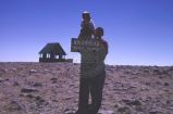
1
Top of Brian Head
1966-07-04
Image
uum_map
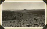
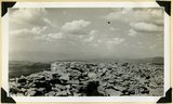
2
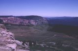
View north along the rim of Markagunt Plateau from Brian Head. Iron County, Utah, 1937.
1937
Image
uum_map
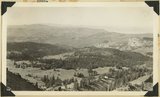
3
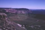
View southeast from top of Brian Head. Hancock Peak in center middle distance; Paunsaugunt Plateau on left horizon. Iron County, Utah, 1936.
1936
Image
uum_map
4
View southwest from Brian Head, showing head of Cedar Canyon, the northern Kolob Plateau, and Pine Valley Mountains (in distance). Iron County, Utah, 1937.
1937
Image
uum_map
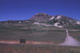
5
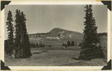
View to Brian Head Peak, highest in southwestern Utah
1966-07-04
Image
uum_map
6
View toward Cedar Breaks from Brian Head Peak
1966-07-04
Image
uum_map
7
View toward Cedar Breaks from Brian Head Peak
1966-07-04
Image
uum_map
8
Brian Head, volcanic mass from the north rim of Cedar Breaks, Iron County, Utah, 1937.
1937
Image
uum_map
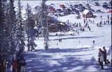
9
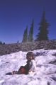
Mary Margaret in snow, Brian Head
1966-07-04
Image
uum_map
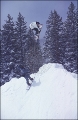
10
Brandon Ruff snowboarding at Brian Head.
1998
Image
uum_map_usa
11
Brandon Ruff snowboarding at Brian-Head, Utah, 1998.
1998
Image
uum_map_usa
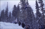
12
Tim Ostler snowboarding at Brian Head, 1998.
1998
Image
uum_map_usa
13
Tim Ostler snowboarding at Brian Head, 1998.
1998
Image
uum_map_usa
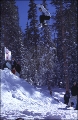
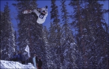
14
Tim Ostler snowboarding at Brian Head, 1998.
1998
Image
uum_map_usa
15
Tim Ostler snowboarding at Brian Head, 1998.
1998
Image
uum_map_usa
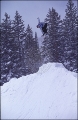
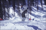
16
Tommy Viele snowboarding at Brian Head, 1998.
1998
Image
uum_map_usa
17
Tommy Viele snowboarding at Brian Head, 1998.
1998
Image
uum_map_usa
18
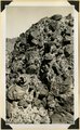
Top of Brian Head (11,280 feet) showing fracture of rhyolite by frost. Iron County, UT. 1941
1941
Image
uum_map
19
Volcanic Conglomerate at the base of a succession of lavas on the cliff face of Brian Head. Iron County, UT. 1941
1941
Image
uum_map
1
-
25
of
19