Home
Browse
Ask Us
Chat
Harmful Language Statement
Log in
Photo Archives
Advanced Search
About
Over 70,000 photos covering a variety of topics from Marriott Library Special Collections
Year
1913
1914
1915
1916
1917
1918
1919
1920
1921
1922
1923
1924
1925
1926
1927
1928
1929
1930
1931
1932
1933
1934
1935
1936
1937
1938
1939
1940
1941
1942
1943
1944
TO
1913
1914
1915
1916
1917
1918
1919
1920
1921
1922
1923
1924
1925
1926
1927
1928
1929
1930
1931
1932
1933
1934
1935
1936
1937
1938
1939
1940
1941
1942
1943
1944
Type
Image
71
Format
image/jpeg
70
application/pdf
1
Collection
Photo Archives
71
Filters:
Collection Name:
"Herbert E. Gregory"
1
-
25
of
71
<
1
2
3
>
Gallery view
Number of results to display per page
10
25
50
100
200
Sort by Relevance
Sort by Title A-Z
Sort by Title Z-A
Sort by Date Ascending
Sort by Date Descending
Sort by Last Modified Ascending
Sort by Last Modified Descending
Title
Date
Type
1
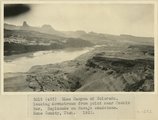
Glen Canyon of Colorado, looking downstream from point near Meskin Bar, Esplanade on Navajo sandstone. Kane County, UT. 1922
1922
Image
2
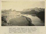
Glen Canyon of the Colorado, looking upstream from point 3 miles east of Crossing of the Fathers, near Meskin Bar. Kane County, UT. 1922
1922
Image
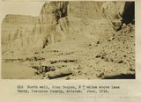
3
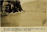
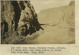
Glen Canyon, 3+ miles above Lees Ferry looking up stream from south bank. June, 1915.
1915
Image
4
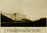
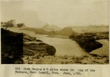
Glen Canyon, 4+ miles above Crossing of the Fathers, Kane County, Utah. June, 1915.
1915
Image
5
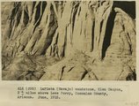
LaPlata (Navajo) sandstone, Glen Canyon, 3+ miles above Lees Ferry, Coconino County, Arizona. June, 1915.
1915
Image
6
North bank of Glen Canyon of the Colorado, near Meskin Bar. Section includes Navajo to Dakota sandstone. Kane County, UT. 1922
1922
Image
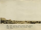
7
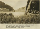
View looking south across Glen Canyon from near Warm Creek, Kane County, Utah. June, 1915.
1915
Image
8
Glen Canyon, 3+ miles above Lees Ferry Coconino County, Arizona. June, 1915.
1915
Image
9
Glen Canyon, 4+ miles above Crossing of the Fathers, Kane County, Utah. June, 1915.
1915
Image
10
Glen Canyon, 4+ miles above Crossing of the Fathers, Kane County, Utah. June, 1915.
1915
Image
11
Glen Canyon, Coconino County, Arizona, 3+ miles above Lees Ferry looking up stream from south bank. June 1915.
1915
Image
12
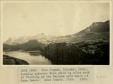
Glen Canyon, Colorado River, looking upstream from point 3 miles east of Crossing of the Fathers near mouth of Kane Creek. Kane County, UT. 1922
1922
Image
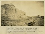
13
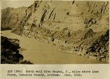
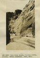
North wall Glen Canyon 2 miles above Lees Ferry, Coconino County, Arizona. June, 1915.
1915
Image
14
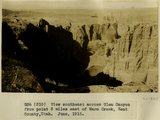
View southeast across Glen Canyon from point 3 miles east of Warm Creek, Kane County, Utah. June, 1915.
1915
Image
15
Glen Canyon of Colorado River near mouth of Rock Creek Canyon wall in Navajo, the top of which forms 'esplanades', slope in lower 'Sentinel,' cliffs in Sentinel sandstone, capped by Dakota. Kane County, UT. 1922
1922
Image
16
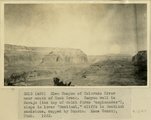
View Glen Canyon of Colorado, mouth of Warm Creek, Coconino County, Arizona. Navajo sandstone. June, 1915.
1915
Image
17
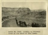
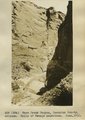
Looking up Colorado River at the mouth of Rock Creek
1922
Image
18
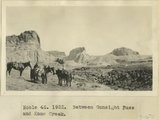
Between Gunsight Pass and Kane Creek
1922
Image
19
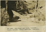
Warm Creek near mouth, Coconino County, Arizona. Navajo sandstone, June, 1915.
1915
Image
20
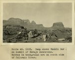
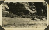
Camp above Meskin Bar on summit of navajo sandstone. Buttes in background are on south side of Colorado
1922
Image
21
Warm Creek Canyon, Coconino County, Arizona, 1+ miles above mouth. June, 1915.
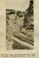
1915
Image
22
Warm Creek Canyon, Coconino County, Arizona.. Navajo sandstone, June, 1915.
1915
Image
23
Warm Creek Canyon, Coconino County, Arizona..Walls of Navajo sandstone, June, 1915.
1915
Image
24
Bottom of Glen Canyon group. Color banded cross-bed sandstone in positions of Wingate, Rosencrans Wash, Mohave County, Arizona, 1936.
1936
Image
25
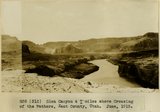
Inscriptions right bank, Glen Canyon below Smith's Fork
1920; 1921; 1922; 1923; 1924; 1925; 1926; 1927; 1928; 1929; 1930
Image
1
-
25
of
71
<
1
2
3
>